
European Geologist Journal 41
From engineering geosciences mapping towards sustainable urban planning
By Helder I. Chaminé*, José Teixeira, Liliana Freitas, Ana Pires, Rui S. Silva, Telma Pinho, Rosália Monteiro, Ana Lúcia Costa, Tiago Abreu, José Filinto Trigo, Maria José Afonso, José Martins Carvalho
*Laboratory of Cartography and Applied Geology (Labcarga), School of Engineering (ISEP), Polytechnic of Porto, Portugal, hic@isep.ipp.pt
Abstract
Maps are of key topical importance in urban geoscience and engineering practice, mainly in field data synthesis and communication related to a number of fields, such as geomatic techniques, applied geology and geomorphology, engineering geology, soil and rock geotechnics, slope geotechnics, subsurface site geotechnical investigations, urban hydrology, hydraulics and sanitation, coastal zones management, urban geoarcheology and heritage, planning and land use. The value of preparing engineering geoscience maps and plans specifically for urban engineering purposes are still a challenging task, particularly to end-users and planners. Nowadays, the application of Geographic Information Systems to geosciences and engineering has become more common. This paper emphasises the importance of an accurate ground field survey and inventory at several scales, GIS mapping and databases, and integrated multidisciplinary urban studies as useful tools to support a sustainable land use planning. Some selected sites are highlighted to demonstrate the importance of urban mapping for land use planning. Thus, in this study the significance of a smart urban geoscience approach is stressed.
Mapping, engineering geosciences, planning
These thoughts from Dearman and Fookes (1974) are still topical: “Undoubtedly the biggest development required in the field of engineering geological mapping is in bridging the apparent gap between the suppliers of the expertise on the one hand and the users of the service on the other” (p. 252). A range of best practices in the preparation of applied geological maps or plans for engineering purposes have been highlighted throughout several key publications in the last half-century (e.g., Dearman and Fookes, 1974; Varnes, 1974; Matula, 1979; Dearman, 1991; Smith and Ellison 1999; Griffiths, 2001, 2002; Dobbs et al., 2012; and references therein). Engineering geological maps or plans are a resourceful database of ground information on lithology, structure, morphology, soil and rock mechanics, hydrology and ground investigation conditions, among others. The purpose of these maps or plans depends on scale, such as: i) detailed survey studies, plans and cross-sections (large-scale): 1:50 to 1:250; ii) general maps or plans (large to medium-scale): 1:1,000 to 1:10,000; iii) regional maps and planning purposes (medium to small-scale): 1:50,000 to 1:200,000. The engineering geological plans or maps are particular useful for the applied geologist or engineering geologist, as well as in geological, geotechnical, civil, mining or environmental engineering practice. Engineering geological plans are produced for specific engineering purposes on a large scale either during site investigation or during the construction stage of a project (Dearman and Fookes, 1974; Griffiths, 2001). They are not intended as a replacement for detailed site-specific desk studies or ground investigations (Dobbs et al., 2012).
Dearman (1991) indicated the key importance of the so-called engineering geological zoning map. This identifies areas on the map that have approximately homogenous engineering geological behaviour and conditions. Such zones would normally be derived from the factual data compiled on the base map and consequently should not form part of the original map but can be produced as an overlay (Griffiths, 2001). In addition, comprehensive and accurate engineering geological plans associated with so-called unforeseen ground conditions play an important role in supporting or rejecting some design and/or construction options. Dobbs et al. (2012) state they serve to raise the awareness of the impact that geology has on planning and development, and act as a reminder of the importance of engineering geology (and correlated disciplinary areas, such as hydrogeology, environmental geology, applied geomorphology, etc.) in reducing the hazards or risks associated with human interaction in the built and natural environment. In short, all geotechnical practitioners aim to contribute to the correct study of the ground behaviour of soils and rocks, its applications in sustainable design with nature and environment and to the development of society (e.g., Dearman and Fookes 1974; McHarg, 1992; Griffiths, 2002, 2014). That approach stresses particularly the key importance of field-based training in applied geoscience and engineering geology for geologists, engineers, architects and planners (Griffiths, 2014), as well as GIS-based mapping for geoengineering purposes and communication skills in applied geosciences (e.g., Chaminé et al., 2013, 2014; Marker, 2015).
New developments in mapping (sketch or general maps, engineering geological maps and geotechnical maps, at diverse scales) take on critical importance in further stages of ground investigations and modelling. It is also important to highlight the value and cost-effectiveness of accurate mapping for geoengineering, georesources and planning purposes (Griffiths, 2002, 2014), Figure 1.

Figure 1: Cloud diagram based on keywords about the engineering geological maps and images illustrating the use of maps in engineering geosciences practice, as well as communicating and teaching applied geosciences in the field.
Urban engineering geosciences mapping in practice
Bandarin and van Oers (2015) state an important issue: “As much as cities are a layered built construct, they rest on another layered system, the geological strata formed during Earth’s history. This relationship is a fundamental one, albeit often forgotten with dire consequences for urban conservation and for the protection of urban environments from natural hazards. (…) the way in which the geological setting has determined the ways in which cities were built, their morphology, building materials and building types, as well as the way they were able to adapt to the hydrological and ecological constraints.” (p. xiv-xv).
Urban geoscience is an interdisciplinary and transdisciplinary field encompassing earth sciences, environmental sciences and socioeconomic sciences for addressing Earth-related problems in urbanised areas (e.g., see details in the multivolume from the “Atlas of Urban Geology” (United Nations) https://www.un.org). Chaminé et al. (2014) highlight the importance of urban geoscience evolving to a holistic paradigm of smart urban geoscience, particularly related to geology, hydrology, groundwater, rock and soil geotechnics, natural resources, environment, geohazards, heritage and geoarchaeology issues. A core aspect of the smart urban geoscience concept necessarily includes Geographic Information Systems (GIS) as a tool for digital mapping and communication to a broad community. That approach includes the integration of numerous data about all features of urban areas, such as transport, environment, economy, housing, culture, science, population, health, history, architecture, heritage, etc. In addition, the format of a balanced multipurpose engineering geological map depends largely on its main purpose and the requirements of the end-users, as well as the need to communicate information to all agents involved (practitioners, researchers, stakeholders, decision makers and the public), as depicted in Figure 2.

Figure 2: The main scientific and technical fields of applications of engineering geoscience mapping for urban areas related to applied geosciences, geotechnics and planning.
In engineering geological mapping assessment, it sounds more accurate to create a comprehensive approach, both scientific and technically and also economically (e.g., Varnes, 1974; Matula, 1979; Dearman, 1991; Griffiths, 2002, and references therein) in order to: i) acquire a rather complete set of engineering geological data; ii) field-map systematically larger areas in different scales; iii) collect the comprehensive information in special data banks; and iv) use GIS-based mapping techniques. Table 1 shows the main types of engineering geological and/or geotechnical maps/plans.
Table 1: Summary data for engineering geological maps and plans (revised and updated from Dearman and Fookes 1974).

There are some fundamental types of GIS-zoning maps at various scales for engineering, georesources and planning purposes (e.g., Matula, 1979; Griffiths, 2002; Chaminé et al., 2013): i) maps for ground site investigations of engineering geological assessment and design geotechnical parameters, including mineral and groundwater resources and hazards; ii) maps for protection and sustainable exploitation of georesources, including groundwater resources; iii) maps for municipal and/or regional planning, land development and construction; iv) maps for delimitation of endangered areas, for organising the warning systems, and for recommendation of measures against active or potential geological hazards; and v) maps for protection of vulnerable geological environments prone to undesirable changes caused by development and/or geohazards. Table 2 provides a main checklist related to the basic information that should be recorded on the engineering geological map.
Table 2: Basic information data to be recorded on an engineering geological map (updated from Griffiths, 2001).

Concerning the communication and dissemination of geological information in urban areas planning, Marker (2015) raised several important issues: i) development should be carried out balancing social, economic and environmental impacts in planning policies and decisions supported by sustainability and environmental appraisals, site investigations and public consultations; ii) scientific and technical ability should be harmonised with social and economic data, such as geoscience data on mineral, water, soil and conservation resources; ground conditions for development; areas potentially affected by hazards; sources of emission to the air, soil and water; and potential waste management sites; iii) many participants in the planning process have limited understanding of geoscience issues; iv) diverse audiences require customised results in straightforward language with good illustrations and local examples. In addition, geoscientists, engineers, Earth-related professionals and planners should use maps and GIS because these are good means of communication, but careful explanation is necessary; v) dissemination needs early and continuing engagement with stakeholders and often needs to be repeated.
Engineering geological mapping needs to advance towards an insightful cartographic reasoning concept established on geomatic techniques, fieldwork, engineering geosciences, Earth-based systems conceptualisation and numerical ground modelling, among others.
Selected sites: coupling engineering geoscience mapping and urban planning
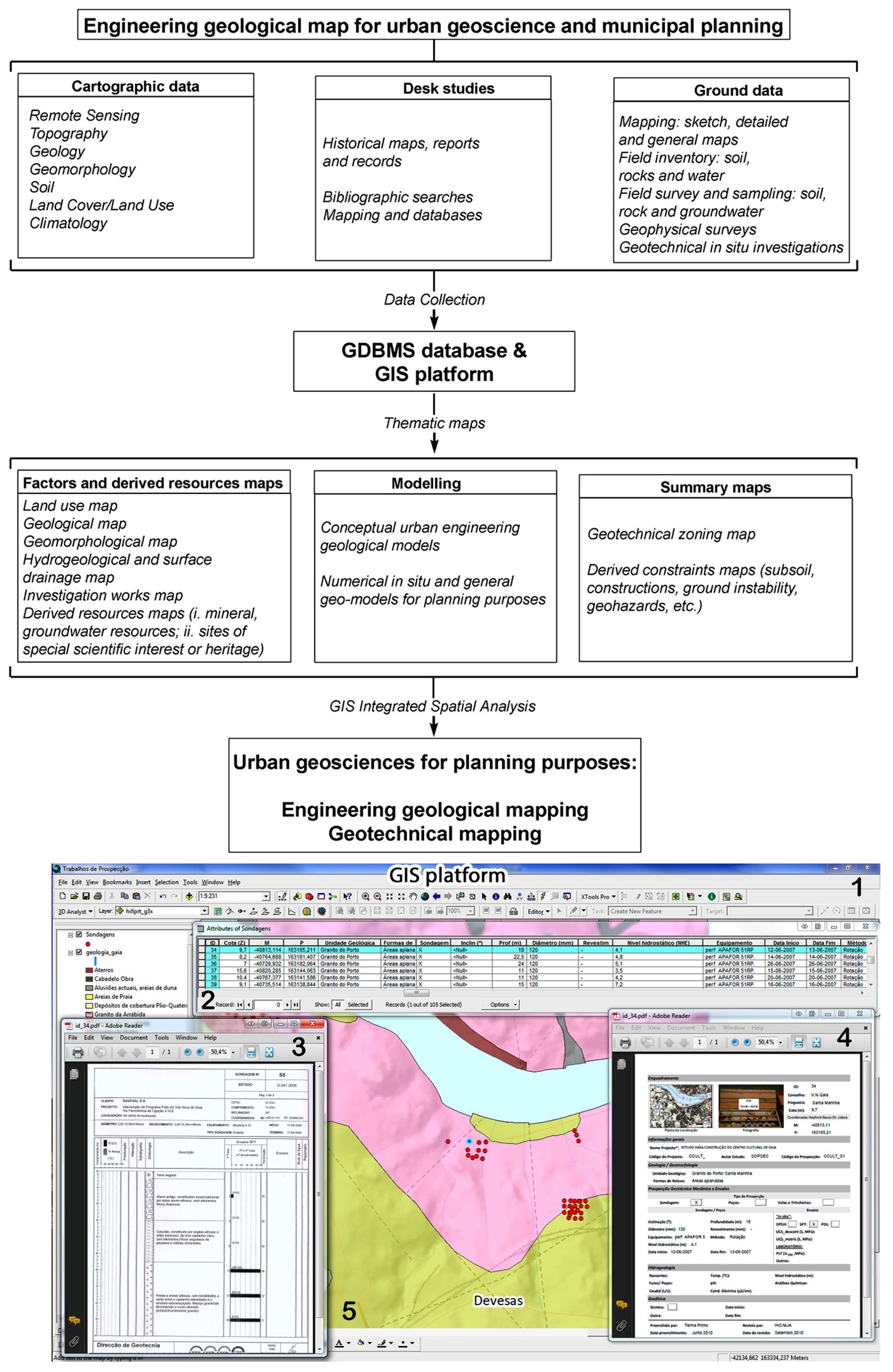
A comprehensive integrated study of urban geoscience was carried out at two selected urban sites of NW Portugal (the cities of Vila Nova de Gaia and Penafiel). The study coupled GIS-based mapping with urban geotechnical and groundwater assessments, respectively. Thematic maps were prepared from multi-source geodata, namely remote sensing, morphotectonic and geological mapping, as well as geotechnical and hydrogeological field surveys. These maps were converted to GIS format and then integrated with the intention of building engineering geological maps and/or environmental hydrogeological maps that combine geohazards assessments and environmental protection groundwater resources focused at the municipal planning level. The basic techniques of mapping, engineering geosciences, applied geomorphology, and applied hydrogeology were applied at the study sites (e.g., Dearman, 1991; Griffiths, 2002; Teixeira et al., 2013; Freitas et al., 2014, and references therein). This integrative approach allowed the basic description of rock masses and established engineering geosciences maps (using particularly the engineering codes of practice of several organisations: IAEG – International Association for Engineering Geology and the Environment; GSE|GSL – Engineering Geology Group of the Geological Society of London; ISRM – International Society for Rock Mechanics; ISSMGE – International Society for Soil Mechanics and Geotechnical Engineering; CFCFF – Committee on Fracture Characterization and Fluid Flow). Figure 3 presents a flow chart of the engineering geological map for urban geoscience and municipal planning.
This approach deals with a holistic and systematic methodology that encompasses several layers of information obtained from diverse sources, such as field data, ground investigations, laboratory testing and historical maps, charts and/or documents. The thematic maps are developed by using all the layers and inputs. Subsequently, the information is embedded in GIS software and geodatabases. Finally, these outputs and the data analysis will support the framework of modelling issues (e.g., Oliveira et al., 2009; Chaminé et al., 2010; Teixeira et al., 2013; Freitas et al., 2014; Pires et al., 2016).

Figure 3: Conceptual flow chart of the engineering geological map for urban geoscience and municipal planning. 1. Application tool to create hyperlinks between features (line, point or polygon) and other files; 2. Database related to ground investigation information; 3. Geotechnical borehole datasheet; 4. Geotechnical inventory datasheet (field and desk data); 5. Detailed investigation works mapping with geological background information.
Vila Nova de Gaia site
The study area highlights the importance of a geological and geotechnical urban study for a better understanding of granitic rock slopes stability in Vila Nova de Gaia’s (NW Portugal) riverside downtown (particularly in the S. Félix da Marinha, S. Pedro da Afurada and Canidelo sites). In addition, there are significant historical records of rock fall activity in the region (e.g., Oliveira et al., 2009; Chaminé et al., 2010; and references therein). In this region typical slope failure mechanisms result in a range of failure types (e.g., plane sliding, wedge failure, partial toppling and buckling) and are dependent mainly on the rock discontinuities network, slope orientation and severity of the hydroclimatological events.
Vila Nova de Gaia is one of the largest cities in Portugal, with a continuous need for urban development and expansion. The Porto and Vila Nova de Gaia urban areas are built along the hillsides on a littoral platform characterised by a quite regular planation surface dipping gently to the West. This platform was cut by the Douro River in a steep-walled valley with sharp and high slopes that constitute the so-called riverside downtown with its typical entrenched geomorphological framework (Oliveira et al., 2009; Chaminé et al., 2010, 2014; Freitas et al., 2014). The Vila Nova de Gaia urban area is located in a complex geotectonic framework encompassing a crystalline fissured basement of highly deformed and overthrusted Late Proterozoic/Palaeozoic metasedimentary and granitic rocks (Figure 4). The bedrock is mainly composed of phyllites, micaschists, gneisses and granites, while post-Miocene alluvial and Quaternary marine deposits dominate the sedimentary cover. The drainage network reflects the regional tectonic lineament systems (namely NNW–SSE, NE–SW, ENE–WSW). The hydrogeology of Vila Nova de Gaia region is mainly dominated by a diverse of groundwater units such as overlying sediments, weathered rocks, weathered–fissured zones, and fractured hard-rock crystalline substratum.
Figure 4 illustrates the general engineering geology mapping framework of the Vila Nova de Gaia riverside downtown and the main hazard rock slope instability sites for the region. The figure also presents a case study of Afurada rock slope stabilisation (details in Chaminé et al., 2010).

Figure 4: Engineering geological mapping framework and hazard rock slope stability sites for Porto and Vila Nova de Gaia riverside downtown (updated from Chaminé et al., 2010). A, B) Geographical setting and geological background with the main location of unstable rock slope sites; C) 1. Historical rockfall near the Guindais Quay, Porto city, on 27 January 1879 (after the drawing by J.J. Pinto), 2. Photo of Guindais rock slope, before 1881 (kindly shared by the archaeologist Sandra Salazar Ralha), 3. Afurada rock slopes (Rua da Praia, near the S. Pedro da Afurada parish), 4. 5. Rock fall slope failure from Afurada scarp [August 2008]; D) Preliminary engineering geosciences mapping of Vila Nova de Gaia riverside downtown; E) Schematic cross-section of the studied rock slope area (slopes A, B, C) and the basic solution of stabilization adopted. The photos were taken during the stabilisation works and after the stripping of the rock mass (July to August 2009).
S. Pedro da Afurada is a fishermen’s picturesque parish of the Vila Nova de Gaia urban area. The Afurada rock-mass exposure is formed of medium to fine grained, two-mica sheared granite, which outcrops slightly to moderately weathered (W2 to W3) and locally highly weathered (W4). The slope area is a scarp fault, trending NE-SW, limited at the top by the Afurada Church and at the base by the Douro river. The slope area showed historical records of active small to medium failures and there has been reported rock fall, with around 1m3 granitic blocks, as well as small-scale rock fall in surrounding Douro riverside downtown (Chaminé et al., 2010), Figure 4. The total slope length has an extension of 187.5 m and a height that varies from 5 to 15 m above the road, oriented N85ºE. The studied slopes dip about 85° and their evolution is due to rock falls as a consequence of the jointing of the rock mass. The preliminary failure susceptibility of the rock slope was evaluated in terms of the computed SMR [Slope Mass Rating] values. For the studied slope sections, the SMR index pointed to a range of 45 to 53 with instability behaviour of IIIa and IIIb types, which can be classified as fair rock slopes. RMR [Rock Mass Rating] and GSI [Geological Strength Index] geomechanical values allowed the granitic slopes to be classified as poor rock masses. A stabilisation program of further works was accomplished after the geological, geotechnical and geomechanical studies, consisting mainly of the filling of the joints with grout and the systematic bolting of block masses, combined with steel reinforced mesh and, sometimes, with polymeric tridimensional geo-mesh (Chaminé et al., 2010; and references therein), Figure 4.
Figure 5 shows a preliminary study of the geomaterials of the rocky platform near the Atlantic coastline in the so-called Lavadores beach area (Canidelo, NW Portugal). That coastline comprises a dynamic transition between the marine environment and the terrestrial environment. The Lavadores site is characterised by a mixed coastal system comprising rocky platform with boulders and megaboulders, sandy beaches, breakwaters and groins. Immediately north of this site, a sand spit of about 700 m length occurs, the so-called “Cabedelo”, which narrows the mouth of the Douro River. The regional geology of the Lavadores site is comprised mainly of medium to coarse-grained granitic rocks and gneisses. The designation “rocky coast” is currently used to refer to coasts that have fissured rocky substrates in the form of shore platforms with or without coastal rock boulders (Pires et al., 2016; and references therein).

Figure 5: Lavadores rocky coastline (Canidelo, Vila Nova de Gaia, NW Portugal) framework (details in Pires et al., 2016): rock beach boulder mapping and hazard effects on rocky coastline. Beach profiles P1 and P2 were based on the revised Udden-Wentworth scale to describe the size of boulders and block size of other large rocks. The coastal geomorphic mapping includes a boulder mobility analysis, geoforms inventory and boulder pathways.
Coastal geoscience mapping, geomorphological features and geomechanical assessment of the geomaterials were incorporated into the coastal environments research to analyse these features in terms of the behaviour of the structure of different layers and rock/block movement. In addition, the approach displays an integrated procedure for coupling coastal geoscience mapping and high-resolution digital imagery for maritime environmental evaluation (details in Pires et al., 2016). At the Lavadores site a coastal boulder evaluation was made with some identified boulder mobility pathways and their profiles plotted. That approach led to defining a coastal geoscience zoning map based on applied geology, coastal geomorphology and in situ geomechanical investigations, as well as coastal dynamics and rock boulder mobility. Finally, the GIS coastal geoscience maps were very useful to determine zones of vulnerability to coastal erosion and geohazards, to identify hydraulic structure silting up, and to contribute to regional/local coastal planning.
The combined interdisciplinary methodology proved valuable to an enhanced understanding of ground nature and geohazards assessment along a riverside downtown and a coastal shoreline near the Porto and Gaia urban areas. In fact, engineering geosciences mapping play an important role in sustainable urban planning at the municipal scale (Oliveira et al., 2009; Chaminé et al., 2010).
Penafiel site
The selected study site, the Monte do Fogo-Santa Marta granitic rock mass, is located near the Penafiel urban area (NW Portugal). The Monte do Fogo hill is located South of Santa Marta parish (Fig. 6). The regional geology comprises Variscan granitic fractured bedrock. There are some prevailing tectonic lineaments (NNE-SSW to N-S and NW-SE). The crystalline basement is also crosscut mainly by dolerite dykes, aplite-pegmatite and quartz veins. Locally, the geomorphology is characterised by steep slopes and entrenched valleys. The drainage network reveals this tectonic control, which imposed morphostructural features on the area.
The Monte do Fogo rock mass comprises por¬phyritic two-mica granite, coarse grained, and yellowish to grey colour. The outcrops and underground rock masses mapped range from slightly to moderately weathered rock (W1-2 to W3), with highly weathered (W4-5) outcrops observed in the surrounding upper slopes. The rock scanline surveys related to the discontinuity surface conditions can be summarised as: i) fracture intercept (F) is mainly wide to moderate spacing (F2-F3); ii) aperture varies from open to closed, iii) persistence is low to moderate; iv) presence of clay and gouge infillings; v) plane to undulating surfaces, low roughness and iron-stained; vi) rock uniaxial compressive strength is low to moderate (S4-S3); and vii) Geological Strength Index (GSI), based on rock structure versus discontinuity surface condition, ranges typically from 60-70 (i.e., very blocky to blocky, interlocked partially disturbed rock mass consisting of orthogonal discontinuity sets and random fractures).
The Monte do Fogo-Santa Marta groundwater systems were assessed by integrating several techniques taking advantage of GIS-based mapping. Vulnerability groundwater mapping (e.g., DRAT index, i.e., susceptibility index derived from hydrogeological and land use parameters) permitted the assessment of the Monte do Fogo rock mass (galleries network around 250 m long and a maximum depth of 25 m below ground level). An exten¬sive hydrogeological inventory was developed on the surface and underground (Fig. 6). Some old water mines were part of an impressive water supply system for the Penafiel urban area. These water galleries are mostly situated in the slope hills. The inventoried springs are essentially located in lower areas and have very small yields (0.4 L/s). Local groundwaters have median to low temperatures (ca. 18 ºC), are mainly acidic (pH 5.5), and have low electrical conductivities (ca. 250 μS.cm-1). Groundwaters have very low mineralisations and commonly a sodium chloride to sodium-calcium chloride hydrochemical facies. The hyposaline chemical composition of these groundwaters indicates a very shallow circulation.
The groundwater vulnerability assessment applied to the Monte do Fogo-Santa Marta groundwater systems was carried out in order to fulfil the European and Portuguese Legislations defining strategies for the environmental protection of groundwater resources, namely the definition of protection zones around localised groundwater recharge areas. These areas are necessarily considered as strategic areas of protection in land use planning. As can be seen in Figure 6, overall the groundwater vulnerability to contamination in this region is mostly low to moderate. However, two areas should be highlighted with a moderate to high vulnerability, which correspond to alluvia deposits (SW and SSE of Crasto de Cima). Locally, in the surrounding area of Monte do Fogo-Santa Marta mine water, vulnerability is moderate to low, with the highest values being reliant on mainly urban fabric and forested areas. Accordingly, this methodology permitted the delimitation of three protection areas (immediate, intermediate and extended) for Monte do Fogo-Santa Marta groundwater systems, in order to integrate them in future plans of territorial planning.

Figure 6: Monte do Fogo-Santa Marta water mine system (Penafiel, NW Portugal) framework: an example of groundwater mapping for urban planning.
Concluding remarks
According to Pain (2016) since the dawn of civilisation, urban areas have brought both benefits and risks to the health and wellness of their inhabitants. Although some of the hazards have been banished, others remain, and new ones have emerged, i.e., the rise of the “urbanite” (Pain, 2016). In that key framework urban geoscience GIS-based mapping is more topical than ever and has high relevance to the following issues: i) it contributes decisively to balanced urban planning decisions grounded in a sustainable design with nature (McHarg, 1992) and heritage (Bandarin and van Oers, 2015); ii) it supports the necessity of a smart urban geosciences approach based on a reliable conceptualisation on geosystems established on cartographic reasoning for a modern digital city, networking nature, geosciences, heritage and society (Chaminé et al., 2014); and iii) communication and dissemination are needed in urban geoscience in a straightforward way to all participants (i.e., practitioners, researchers, stakeholders, decision makers and public) in the planning process (Marker, 2015).
Mapping plays a central role in urban geoscience for in situ geotechnical investigations, ground modelling, geological resources, heritage and geohazard assessments, and planning purposes. This work highlights the importance of GIS geological engineering mapping as a useful tool to contribute to a balanced urban planning management aiming a sustainable design with nature, environment, heritage and society. This study was focused on the importance of coupling GIS-based mapping and engineering geosciences for urban planning at municipal level. In this approach, urban geoscience studies assume major significance contributing to land/cover use management and planning. Therefore, innovative methodological approaches are required in the collection, analysis, design and modelling of urban data.
The geologist David J. Varnes summarised the overall outlook in an impressive way: ‘(…) engineering geologists are admonished nowadays to speak the engineer’s language, to put maps in a form that planners or even the layman can understand, and to quantify our statements. This is very good, very necessary. But let us also realise that users of our maps may understand us too well; they may see that we extrapolate without giving the odds, that we sometimes map one thing and say it is another without presenting evidence for covariance; and they may be more aware than we that statistical analyses of test results cannot alone serve as reliable measures of in-place heterogeneity. (…) The presentation of quantitative information often is helpful in our effort to gain and hold the attention of engineers, planners, legislative bodies, and other users. But even more important is the need to think and write straightforwardly, logically, and honestly – in a word, clearly. This is more than helpful: it is absolutely essential.’ (Varnes, 1974: 41).
Acknowledgements
This study was partially supported by several projects: LABCARGA|ISEP re-equipment program (IPP-ISEP|PAD’2007/08), SUD’EAU‐2_SOE3/P/E549, and Centre GeoBioTec|UA (UID/GEO/04035/2013). AP was supported by a doctoral scholarship from the Portuguese Foundation for Science and Technology (SFRH/BD/43175/2008). Special thanks are due to M. Gastaldin and R. Fernández-Rubio for kindly reviewing the French and Spanish version of the abstract, respectively. We acknowledge Penafiel Council, Vila Nova de Gaia Council, MOTA-ENGIL SA, SOPSEC SA, TECNOGEO Lda and TARH Lda for all data support. The authors would like to thank the reviewer for helpful comments and input to improve the manuscript. The present paper is dedicated to Professor Ricardo Oliveira, outstanding Portuguese engineering geologist, who promotes high standards and core ethical values in applied geology practice for teaching, engineering, environment and society.
References
Bandarin, F., van Oers, R. 2015. Reconnecting the City: The Historic Urban Landscape Approach and the Future of Urban Heritage. Wiley Blackwell, John Wiley & Sons: London
Chaminé, H.I., Afonso, M.J., Freitas, L. 2014. From historical hydrogeological inventories, through GIS mapping to problem solving in urban groundwater systems. European Geologist – Journal of the European Federation of Geologists, 38, 33-39
Chaminé, H.I., Afonso, M.J., Silva, R.S., Moreira, P.F., Teixeira, J., Trigo, J.F., Monteiro, R., Fernandes, P., Pizarro S. 2010. Geotechnical factors affecting rock slope stability in Gaia riverside (NW Portugal). In Williams, A.L., Pinches, G.M., Chin, C.Y., McMorran, T.J., Massey C.I. (eds.), Geologically Active: Proceedings of the 11th IAEG Congress, Auckland, New Zealand. CRC Press/Balkema, Taylor & Francis Group. pp. 2729-2736.
Chaminé, H.I., Afonso, M.J., Teixeira, J., Ramos, L., Fonseca, L., Pinheiro, R., Galiza, A.C. 2013. Using engineering geosciences mapping and GIS-based tools for georesources management: lessons learned from rock quarrying. European Geologist – Journal of the European Federation of Geologists, 36, 27-33
Dearman, W.R. 1991. Engineering Geological Mapping. Butterworth-Heinemann: Oxford.
Dearman, W.R., Fookes, P.G. 1974. Engineering geological mapping for civil engineering practice in the United Kingdom. Quarterly Journal of Engineering Geology, 7(3), 223-256. DOI 10.1144/GSL.QJEG.1974.007.03.01
Dobbs, M.R., Culshaw, M.G., Northmore, K.J., Reeves, H.J., Entwisle, D.C. 2012. Methodology for creating national engineering geological maps of the UK. Quarterly Journal of Engineering Geology and Hydrogeology, 45(3), 335-347. DOI 10.1144/1470-9236/12-003
Freitas, L., Afonso, M.J., Devy-Vareta, N., Marques, J.M., Gomes, A., Chaminé, H.I. 2014. Coupling hydrotoponymy and GIS cartography: a case study of hydrohistorical issues in urban groundwater systems, Porto, NW Portugal. Geographical Research, 52(2), 182-197. DOI 10.1111/1745-5871.12051
Griffiths, J.S. 2001. Engineering geological mapping. In Griffiths, J.S. (ed.), Land Surface Evaluation for Engineering Practice, Geological Society, London, Engineering Geology Special Publications, 18, 39-42. DOI 10.1144/GSL.ENG.2001.018.01.06
Griffiths, J.S. (ed.). 2002. Mapping in Engineering Geology. Key Issues in Earth Sciences Series, Vol. 1. The Geological Society of London: London.
Griffiths, J.S. 2014. Feet on the ground: engineering geology past, present and future. Quarterly Journal of Engineering Geology and Hydrogeology, 47(2), 116-143. DOI 10.1144/qjegh2013-087
Marker, B. 2015. Communication of geological information in planning of urban areas. In Lollino, G., Giordan, D., Marunteanu, C., Christaras, B., Yoshinori, I., Margottini, C. (eds.), Engineering Geology for Society and Territory – Urban Geology, Sustainable Planning and Landscape Exploitation, IAEG, Springer, 5, 335-338. DOI 10.1007/978-3-319-09048-1_64
Matula, M. 1979. Regional engineering geological evaluation for planning purposes. Bulletin of the International Association of Engineering Geology, 19(1), 18-24. DOI 10.1007/BF02600442
McHarg, I.L. 1992. Design with Nature. 25th anniversary edition, Wiley Series in Sustainable Design, John Wiley & Sons: New York.
Oliveira, R., Gomes, C., Guimarães, S. 2009. Engineering geological map of Oporto: a municipal tool for planning and awareness of urban geoscience. In Culshaw, M.G., Reeves, H.J., Jefferson, I., Spink, T.W. (eds), Engineering Geology for Tomorrow’s Cities: Proceedings of the 10th IAEG Congress, Geological Society, London, Engineering Geology Special Publications, 22, 1-7. DOI 10.1144/EGSP22.I
Pain, S. 2016. The rise of the urbanite. Nature, 531, S50-S51. DOI 10.1038/531S50a
Pires, A., Chaminé, H.I., Piqueiro, F., Pérez-Alberti, A., Rocha F. 2016. Combining coastal geoscience mapping and photogrammetric surveying in maritime environments (Northwestern Iberian Peninsula): focus on methodology. Environmental Earth Sciences, 75, art. no.196. DOI 10.1007/s12665-015-4936-z
Smith, A., Ellison, R.A. 1999. Applied geological maps for planning and development: a review of examples from England and Wales, 1983 to 1996. Quarterly Journal of Engineering Geology, 32, S1-S44. DOI 10.1144/GSL.QJEG.1999.032.00S.01
Teixeira, J., Chaminé, H.I., Carvalho, J.M., Pérez-Alberti, A., Rocha, F. 2013. Hydrogeomorphological mapping as a tool in groundwater exploration. Journal of Maps, 9(2), 263-273. DOI 10.1080/17445647.2013.776506
Varnes, D.J. 1974. The logic of geological maps, with reference to their interpretation and use for engineering purposes. U.S. Geological Survey Professional Paper 837: Washington. https://pubs.er.usgs.gov/publication/pp837
This article has been published in European Geologist Journal 41 – Sustainable land use: How geology can contribute.