
European Geologist Journal 54
Geophysical exploration as a geothermal resources research tool at a granitic basement – the Braga area case study
by Bruno Pereira1, *, Margarida Antunes2, Helena Sant’ovaia3, Luís Gonçalves2, Cláudia Cruz3, João Azevedo1 and Jorge Oliveira1
1 Sinergeo, Lda; R. Manuel Ferreira Araújo 37, 4705-258 Braga, Portugal
2 Instituto de Ciências da Terra, Pólo da Universidade do Minho, Campus de Gualtar, 4710- 057 Braga, Portugal
3 Departamento de Geociências, Ambiente e Ordenamento do Território, Faculdade de Ciências da Universidade do Porto; Instituto de Ciências da Terra, Pólo da Universidade do Porto, Rua do Campo Alegre 687, Porto, Portugal
Contact: brunopereira@sinergeo.pt
Abstract
Geothermal resources are increasingly being considered as a strategic alternative in energy production, especially with the latest geopolitical developments. The densely populated Braga region, in NW Portugal, is endowed with a geostructural setting that enables the existence of several thermal water occurrences, spatially associated with a deep-rooted structure – the Vigo-Régua shear zone, set in a granite context. Given the latest advances in geothermal energy production, it is possible to predict a mid- to long-term implementation of geothermal energy production in the vicinity of that deep rooted structure. Although strongly encouraging, the exploratory geophysical, geochemical and geological data are still insufficient to deliver a definitive frame of the potential energy associated with the estimated reservoirs. Ongoing work combining gravimetric, radiometric and geochemical data will provide a better understanding of the deeply concealed structures.
Cite as: Pereira, Bruno, Antunes, Margarida, Sant’ovaia, Helena, Gonçalves, Luís, Cruz, Cláudia, Azevedo, João, & Oliveira, Jorge. (2022). Geothermal resources research in a granitic basement – the Braga area case study (NW Portugal). European Geologist, 54. https://doi.org/10.5281/zenodo.7882843

This work is licensed under a Creative Commons Attribution 4.0 International License.
1. Introduction
Geothermal resources are considered a sustainable and environmentally friendly alternative to produce energy. The European Federation of Geologists (EFG) states that geothermal energy, both shallow and deep, is part of the answer to meet the issue of efficient renewable energy production [1].
The exploration of geothermal resources combines a set of different methodologies and techniques, as described in [2], in which the use of geophysics has an important specific role. However, there is always a significant degree of uncertainty that creates gaps that need to be filled with consistent geological models [3]. Geophysical methods like gravimetry can be used to obtain useful information regarding the deep geostructural setting of geothermal sites, and therefore its fluid circuits. Also, radiometry can be used to detect radiogenic heat generating rocks, potential sources of underground heat.
The north of Portugal seems to be a suitable area for the exploitation of geothermal resources due to its mean geothermal gradient of 35.5 °C/km [4] and a mean heat flow value of 95 mW m-2, derived from borehole measurements [5].
The Braga region, located in NW Portugal, is a zone with well-defined geostructural indicators (Figure 1). These indicators are the presence of a deep-rooted structure, the Vigo-Régua shear zone, with its associated secondary structural pattern of faults and fractures; the existence of several thermal water occurrences spatially associated with the main faults (Figures 2,3), as well as other structural settings; the definition of strong gravimetric anomalies correlatable with the existing geology; and the indication of significant temperatures derived from geothermometry. The application of chemical geothermometers in the region of Braga has allowed the temperature estimate approach of the geothermal reservoirs that feed the researched thermal water occurrences, as well as the its circulation depth. Several studies have demonstrated the suitability of the application of environmental isotopes in the characterisation of geothermal reservoirs in different zones of the Maciço Antigo in northern Portugal [6-10].
The estimated reservoir temperature for the studied sites allows us to predict the feasibility of using direct heat and to promote the eventual electricity production, considering the Lindal diagram [11]. Good results could also be obtained with other complementary techniques, such as electric resistivity and induced polarisation, in specific settings.
This research intends to upscale the existing knowledge regarding the Enhanced Geothermal System (EGS) potential of a specific region of the Variscan granitic basement, as classified in [12], attempting – although in an exploratory approach – to define functional regional guides for geothermal research and exploration.
According to Nicholson [13], systems with temperatures below 150 ºC are considered low-temperature systems. The deduced water temperature of the studied Portuguese thermal occurrences is mainly below this threshold, with some values above it. As stated before, these results need to be addressed with caution.
The studied area is densely populated, with annual energy consumption of 3×10⁹ kWh in the broader region and a 7×10⁸ kWh in the city surroundings in 2020, which is equivalent to 2.1×10⁵ tonnes of oil equivalent [14]. The main motivation of this work is to better understand the local deep geostructural setting within the scope of geothermal resources research tools development.
2. Geological setting
The Braga area (Iberian Peninsula; NW Portugal) is located in the Central Iberian Zone (CIZ) of Portugal and in the Galicia–Trás-os-Montes Zone (TMZG) (Figure 1) [15].
The CIZ was formed in the Variscan Orogeny, resulting from the continental collision between the continents Gondwana and Laurussia, which began at the end of the Silurian and beginning of the Devonian, characterized by subduction and obduction mechanisms of the oceanic crust [16]. The Variscan cyclebegan with the opening of oceans bordered by passive margins (540–420 Ma), followed by the beginning of the subduction in the Palaeozoic Oceans with the subordinate opening of marginal basins post-arc and ophiolitic blade obduction (420–390 Ma) and high pressure thermometamorphic events. Subsequently, continental collision and orogeny occurred with sedimentary and tectonic polarity oriented towards the foreland zones (390–300 Ma), accompanied by thermal anomalies, generating abundant granitoids and high-temperature metamorphism, followed by a transcurrent intracontinental deformation and localised orogenic collapse (300–270 Ma) [17]. Variscan deformation is characterised by polyphasic processes and is divided into three tectonic phases, D1, D2 and D3 [16,17,18]. The D1 phase generated folds with NW-SE predominant orientation, but in allochthonous, parautochthonous or autochthonousformations, generates folds with different orientations and vergence, with folds with vertical axial plane in the autochthonous and slightly vergent in the parautochthonous. The D2 phase occurred close to the D1 phase, with the formation of lying folds facing SE being well represented in the allochthonous and the parautochthonous [16], with the development of sub-horizontal foliation (S2) [18]. The D3 phase, unlike the previous ones, occurred in all terrains, autochthonous, parautochthonous and allochthonous.
At a regional level, vertical and NNE-SSW oriented corridors and ductile-brittle and brittle shear zones are defined. Still in this phase, previous structures that possibly developed in D1 or D2 (Vigo-Régua shear zone) were reactivated in a transcurrent regime [19]. The Variscan orogeny originated a crustal thickening that produced granitic magmas by anatexis. The Portuguese Variscan granites are synorogenic and can be divided into two groups, two-mica granites and biotitic granites [20]. Two-mica granites are syntectonic relatively to the D3 (syn-D3) Variscan deformation phase, and are generally located along the core of regional bends D3, with NW-SE direction (D3, last phase of Variscan ductile deformation). They are usually leucocratic granites, with muscovite and primary biotite, resulting from the wet crystallisation of peraluminous magmas, originating from a mesocrustal level [20]. The second group, biotitic granites, originate deeper in the crust and correspond to relatively dried magmas, and if muscovite occurs in this group, it is of secondary origin [21]. Biotitic granites are mainly controlled by D3 shears and late Variscan tectonic structures. The emplacement period of granites, relative to the D3 phase, can be syn-D3 (320–313 Ma), late-D3 (311–306 Ma), late to post-D3 (300 Ma) or post-D3 (299–290 Ma) [22].
In the study area, the relief morphology is marked by tectonics, where the lithologies have been strongly affected by the Variscan NNE-SSW and NW-SE fracturing, and reactivated by Alpine movements that generated their own ENE-WSW fracture network [23]. The granitoids emplacement that outcrops in this area was mainly conditioned by the Variscan phase. Late-Variscan tectonics is marked by the effect of maximum compression with NE-SW orientation caused by NW-SE and fracturing well marked in this area by the great alignments of the river network [23].
The regional setting of the study area can be observed in Figure 1, where the major tectonic-stratigraphic units are identified.
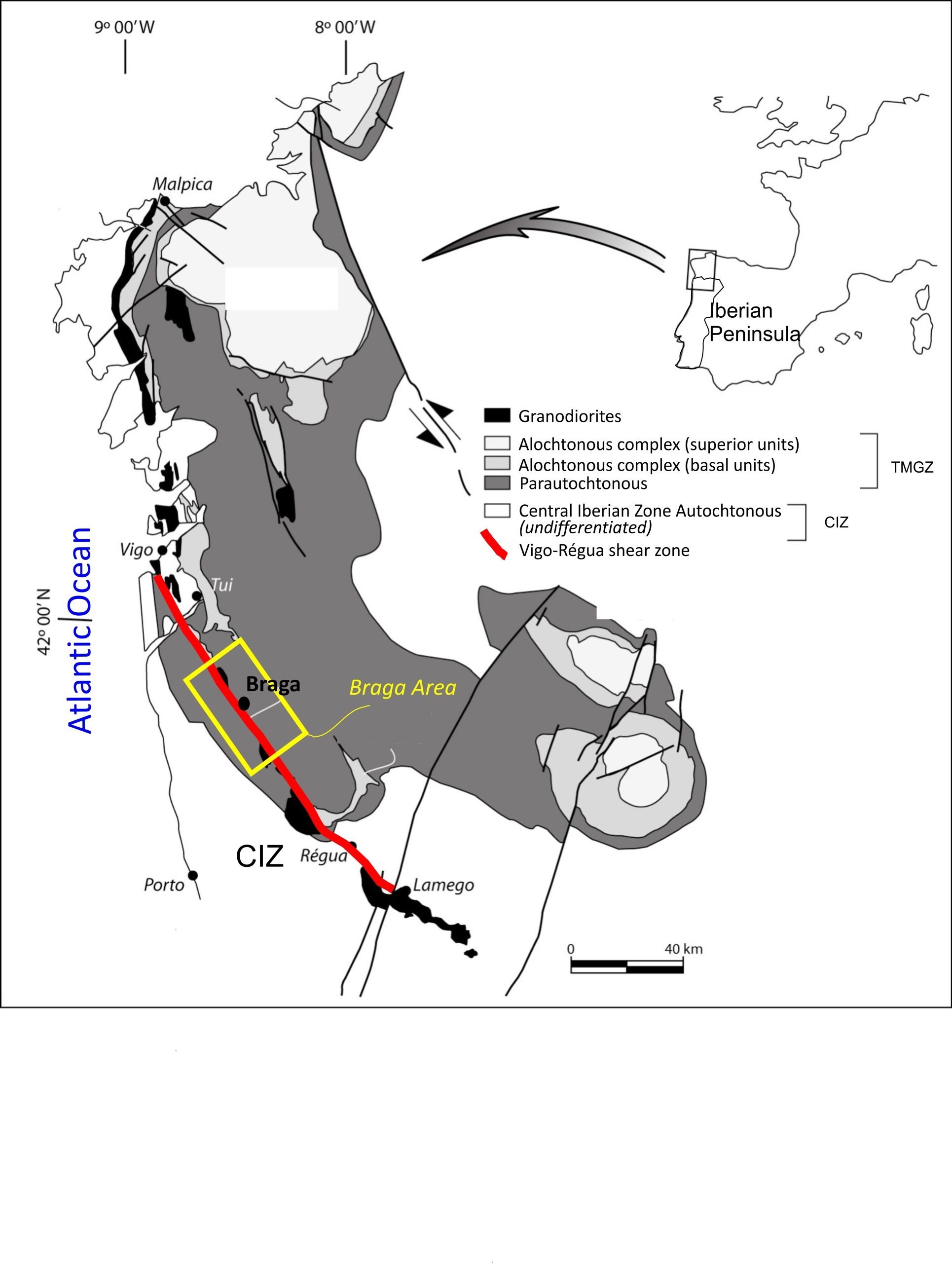
Figure 1: Geological-structural setting of the study area.
The Vigo-Régua ductile shear zone corresponds to the southernmost segment of a larger system (the ductile shear zone of Malpica-Lamego); (Figure 1), with a dominant NW-SE orientation parallel to the Variscan Chain on the NW of the Iberian Peninsula and with a total extension of 275 km [20].
The Vigo-Régua ductile shear zone segment has a multiphase kinematic interpretation within the Variscan orogeny: left-hand movement in D1 and D2 (370–310/315 Ma) and right-hand movement in D3 (310/315–300 Ma) [20]. In D1, a thrusting event is identified, followed by an episode changing the structural vergence, previous to D3. This shear zone has a sub-vertical foliation or W-slanted penetration and a sub-horizontal stretching lineation [19]. This shear develops along parautochthonous and associated granitic rocks. The granodiorite rocks are structurally controlled by this shear zone [19].
2.1. The Braga Area
The studied area is located within the Cávado and Ave River watersheds, in NW Portugal (Figure 2), included in a broader unit defined as Portuguese Hydrographic Region 2 (RH2). The combined watershed area is of roughly 3,060 km2.
The average annual flow on the Cávado and Ave Rivers watershed is about 3,402 hm3. It is estimated that the rainfall in the combined catchment area is on average 1,788 mm/year, ranging from 968 mm to 3,253 mm [23], which guarantees the constant recharge of groundwater systems. There are different thermal water occurrences located near and spatially related to the Vigo-Regua shear zone (Figure 2). Data from occurrences surrounding the study area can be observed in Table 1.
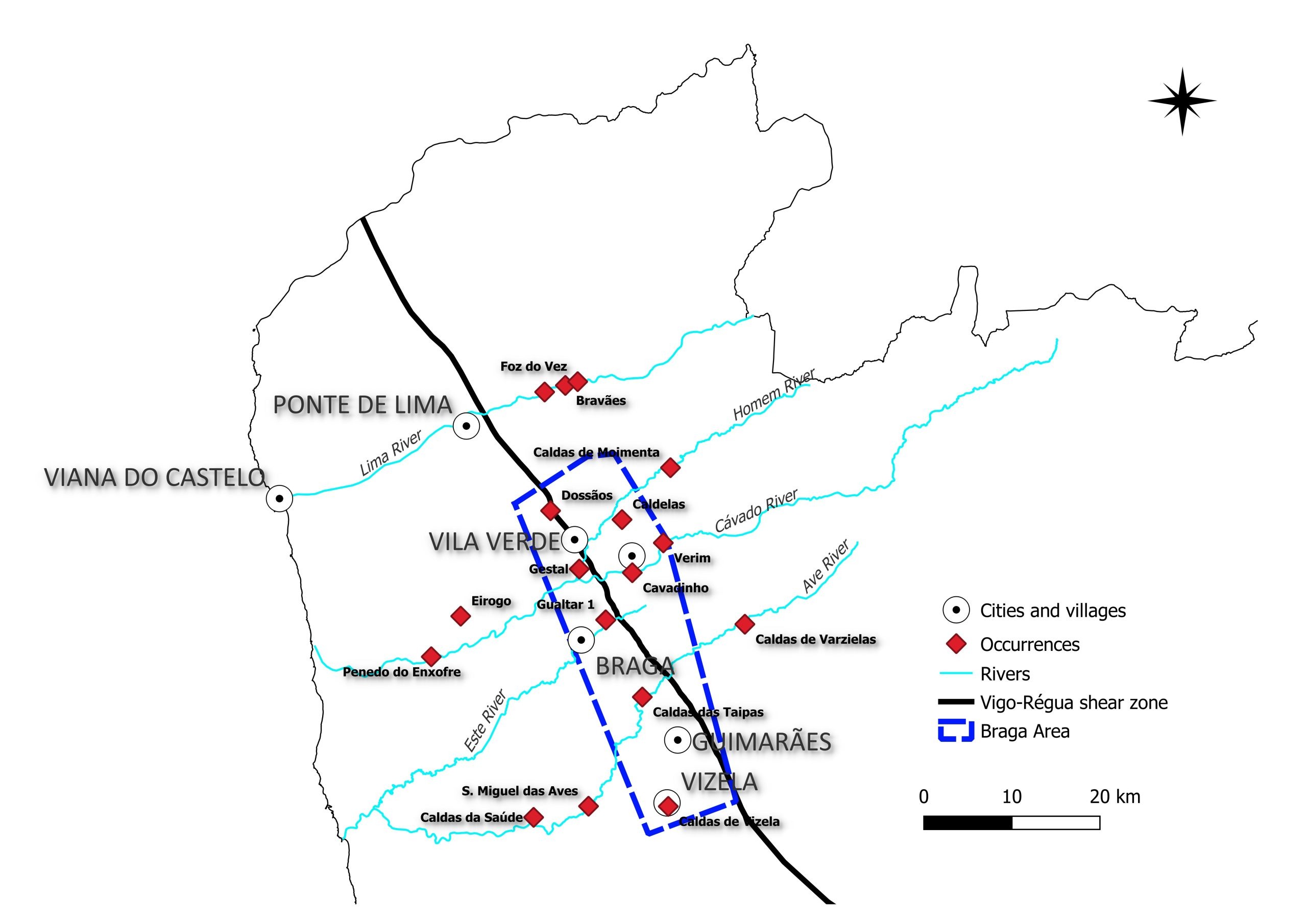
Figure 2: Identified thermal occurrences in the vicinity of the Vigo-Régua shear zone from the Braga region.
Table 1: Data from thermal water occurrences in the Braga region.
| Temperature (°C) | pH | Depth (m) | Water Type | Use | |
| Caldelas(a) | 31 | 8.2 | 179 | Bicarbonate | Spa |
| Cavadinho/Crespos(b) | 20.4 | 9.25 | 0 | Sulphureous | None |
| Verim(b) | <20 | 8.86 | 0 | Sulphureous | None |
| Gestal(b) | 15.5 | 8.9 | 0 | Sulphureous | None |
| Caldas das Taipas(b) | 30 | 8.0 | n.d. | Sulphureous | Spa |
| Caldas de Moimenta(a) | 21 | 9.1 | n.d. | Sulphureous | Spa |
| Caldas de Vizela(a)* | 43.5 | 9.34 | 62 | Sulphureous | Spa |
| Gualtar(c) | 18.0 | 7.41 | 0 | Sulphureous | None |
Legend: (a) [24], (b)[27], (c)[26]; *(b)65ºC registered historically
The geomorphology of the area is mainly characterised by a typically alveolar morphology with extensive and wide valleys as well as orographic systems with steep slopes, with graben type and reliefs of the Horst as a result of a base geologically markedly granitic and strongly controlled by tectonics [24].
The NNE–SSW and ENE-WSW structures are well marked in the orientation of the rivers and tributaries (Figure 3) as well as in the main elevations as a result of the late-Variscan tectonic action and the Alpine movements.
The Cávado deposits occur mainly in the river’s right margin, in a graben morphological depression, as well as in the Ave River. The strong NW-SE tectonic control can be observed in the granitic plutons outcropping shapes (Figure 3). Also, the E-W valleys tend to be filled with detrital materials, suggesting graben-like structures associated with these late-Alpine valley directions. The metasediments only outcrop on the west block of the Vigo-Régua shear zone, which suggests the upward movement of the East block of this right-hand structure. In the same figure a simplified view of the brittle structures (faults, fissures and gashes) is shown, highlighting crosscutting nodes near known occurrences. Also, the outcropping lithologies are identified.

Figure 3: Geological map of the study area [25][26][28][29][30].
When observing this figure, it is quite clear that cross-cutting fault and gash structures of WSW-ENE with NNW-SSW directions are associated with the known occurrences, with the exception of the Cavadinho thermal occurrence. This structural criterion was a base for the selection of the three studied occurrences, because of the contrast with the surrounding rock, induced by negative Bouguer anomalies expected in deeply fractured zones [31]. Also, cumulatively, these occurrences are located near urban centres and geothermometric data are available. Isotopic studies [24] and [27] allowed an approach towards the deeper circulation water temperature. The results can be viewed with “optimistic” and “pessimistic” approaches, and need to be addressed with caution. The range of values for water temperature estimates range from 59 ºC to 132 ºC applying the quartz geothermometer [24] and [27] and from 59 ºC to 153 ºC using the Na/K geothermometer [24] and [27]. These estimates are well above the natural spring water temperatures, as shown in Table 2. The geology of each one of the three selected sites can be observed in Figure 4 (From north to south: Caldelas, Cavadinho, Gualtar).
Table 2: Water temperature (°C).
| Qz geothermometer | Na/K geothermometer | Measured Temperature | |
| Caldelas(a) | 71 | 153 | 31 |
| Cavadinho/Crespos(b) | 77 | 59 | 20.4 |
| Gualtar | no data | no data | 18 |
Legend: (a)[24] (b) [27]
The Caldelas site geology consists of three outcropping granites, with NW-SE direction, cross-cut by NW-SE and WSW-WNE faults and gashes. The Cavadinho site has only one outcropping granite, with crosscutting faults and gashes with NNE-SSW and WSW-ENE directions. The Gualtar site has a more complex geology with three outcropping granites, as well as metasediment, and is crossed by the Vigo-Regua shear zone.
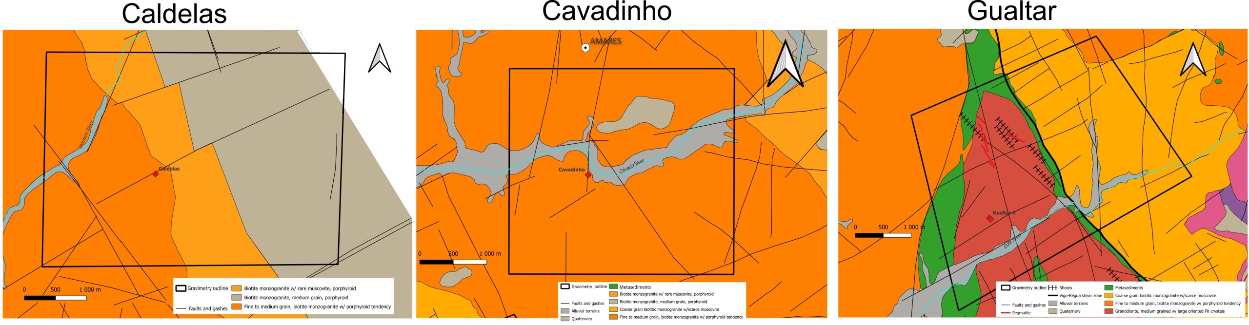
Figure 4: Geological setting of the selected sites.
3. Materials and Methods
The present study is comprised of several tasks: site selection based on cross-cutting structures and thermal occurrence locations, collection and interpretation of gravimetric data and interpretation of radiometric data.
An exploratory approach is considered using combined geophysical tools. Considering the extensive demography and highly urban areas on the studied region, the use of electromagnetic and electric geophysical methods is considered unsuitable due to logistics and signal interference. The choice of geophysical tools fell on the use of gravimetry and radiometry, with the first one aiming to detect density contrasts related to outcropping structures/lithologies that could point out possible reservoirs in low density areas. Radiometry is used with the main objective of revealing radiation anomalies related to highly radiogenic granites [31], which are also structurally controlled. The database [33] was used to model the radiometric background of the study area and selected sites. The gravimetric surveys were conducted using a Pioneer, Worden 679, model 155 gravimeter with full DGPS follow-up. Specifics on the conducted gravity surveys can be consulted in References [34] and [35].
4. Results
Figure 5 presents and compares the results from the gravity survey, expressed in complete Bouguer anomaly (mGal) and the radiometric background (nGy/h). A clear relation between radiometric and gravimetric highs can be observed for the Caldelas site. The known thermal occurrence is located in a sudden transition zone between high and low anomalies.
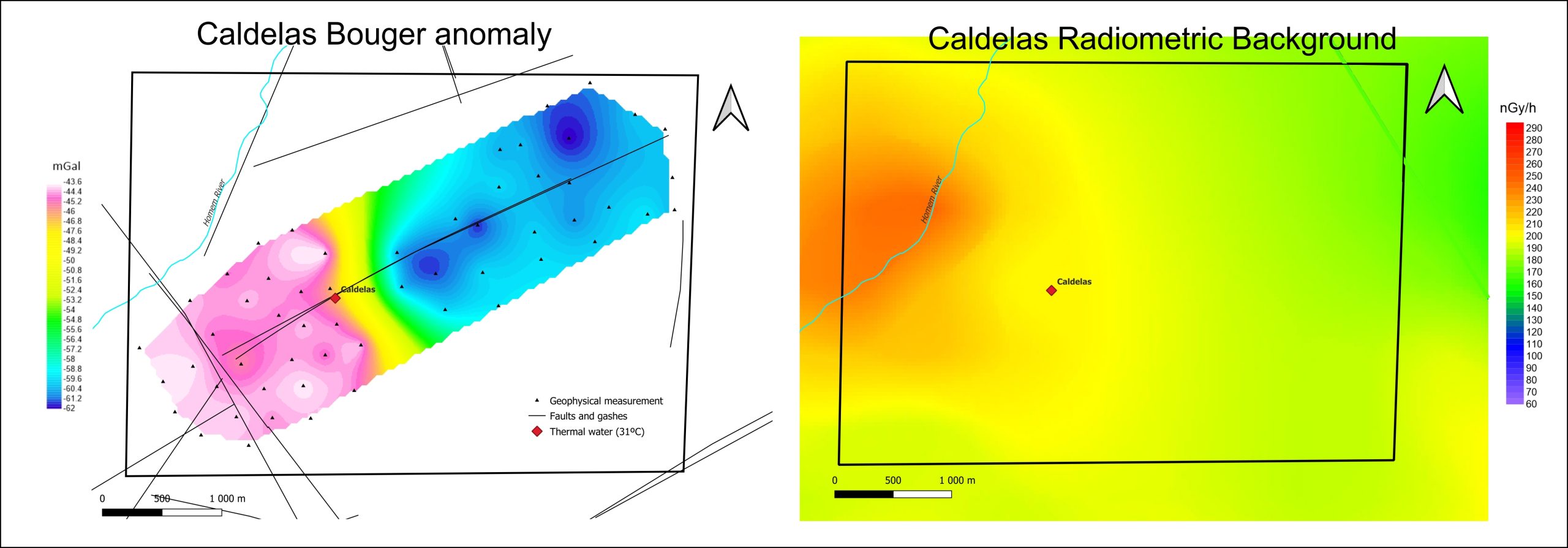
Figure 5: Bouguer anomaly and radiometric background at the Caldelas site.
The results obtained for the Cavadinho site (Figure 6) also show that a clear relation between radiometric and gravimetric highs can be observed, although this is not quite as conspicuous as at the Caldelas site. Here also the known thermal occurrence is located in a transition zone between high and low anomalies.
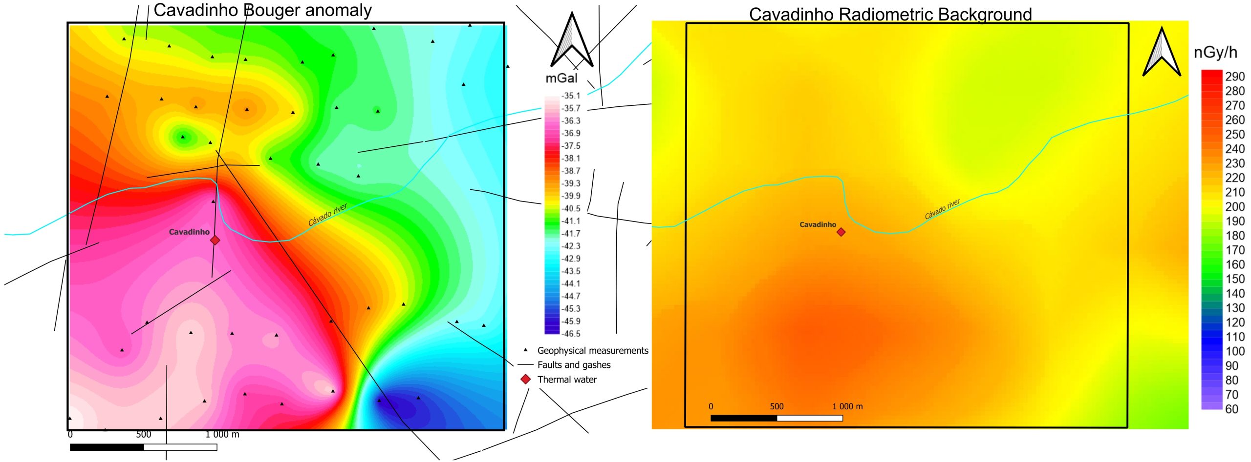
Figure 6: Bouguer anomaly and radiometric background at the Cavadinho site.
The Gualtar site results (Figure 7) show a more diffuse spatial relation between radiometric and gravimetric highs. The known thermal occurrence is located near a sudden transition zone between high and low anomalies.
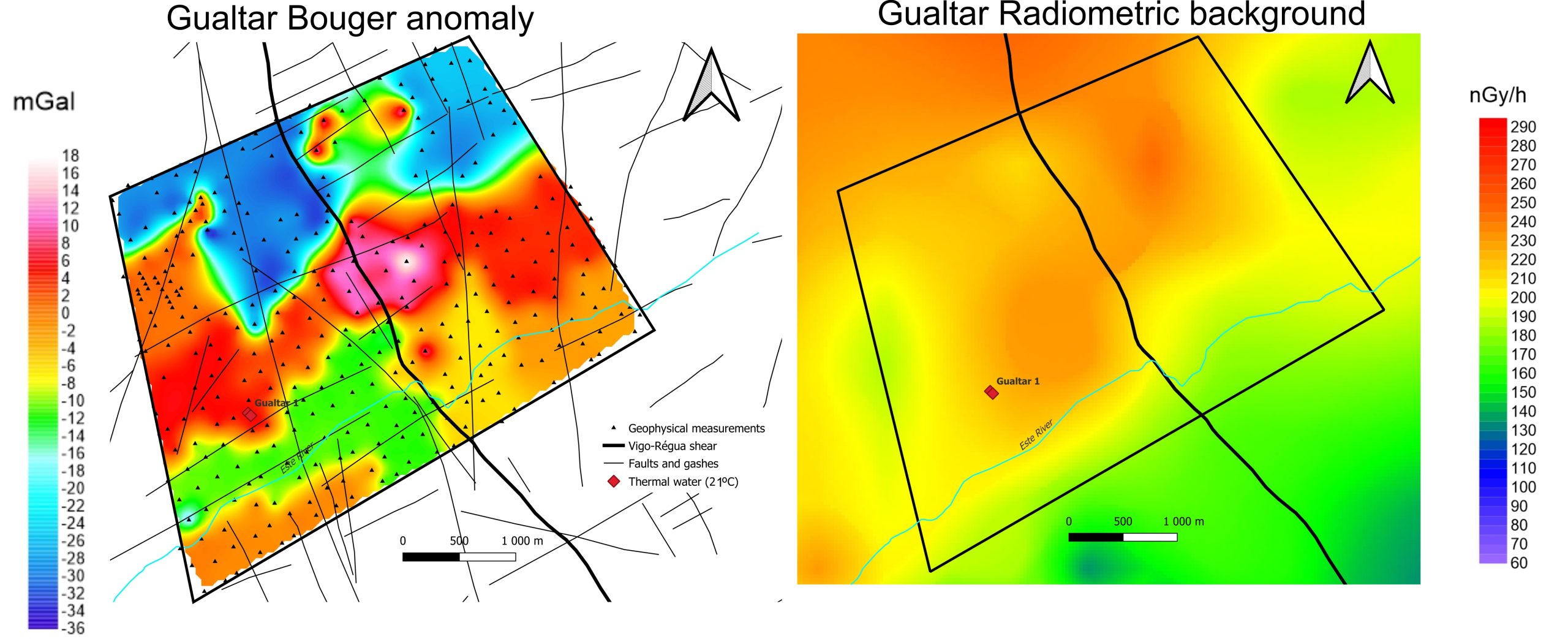
Figure 7: Bouguer anomaly and radiometric background at the Gualtar site.
A broader view of the results can be attained in Figure 8. There is a clear association between known thermal occurrences and radiometric highs.
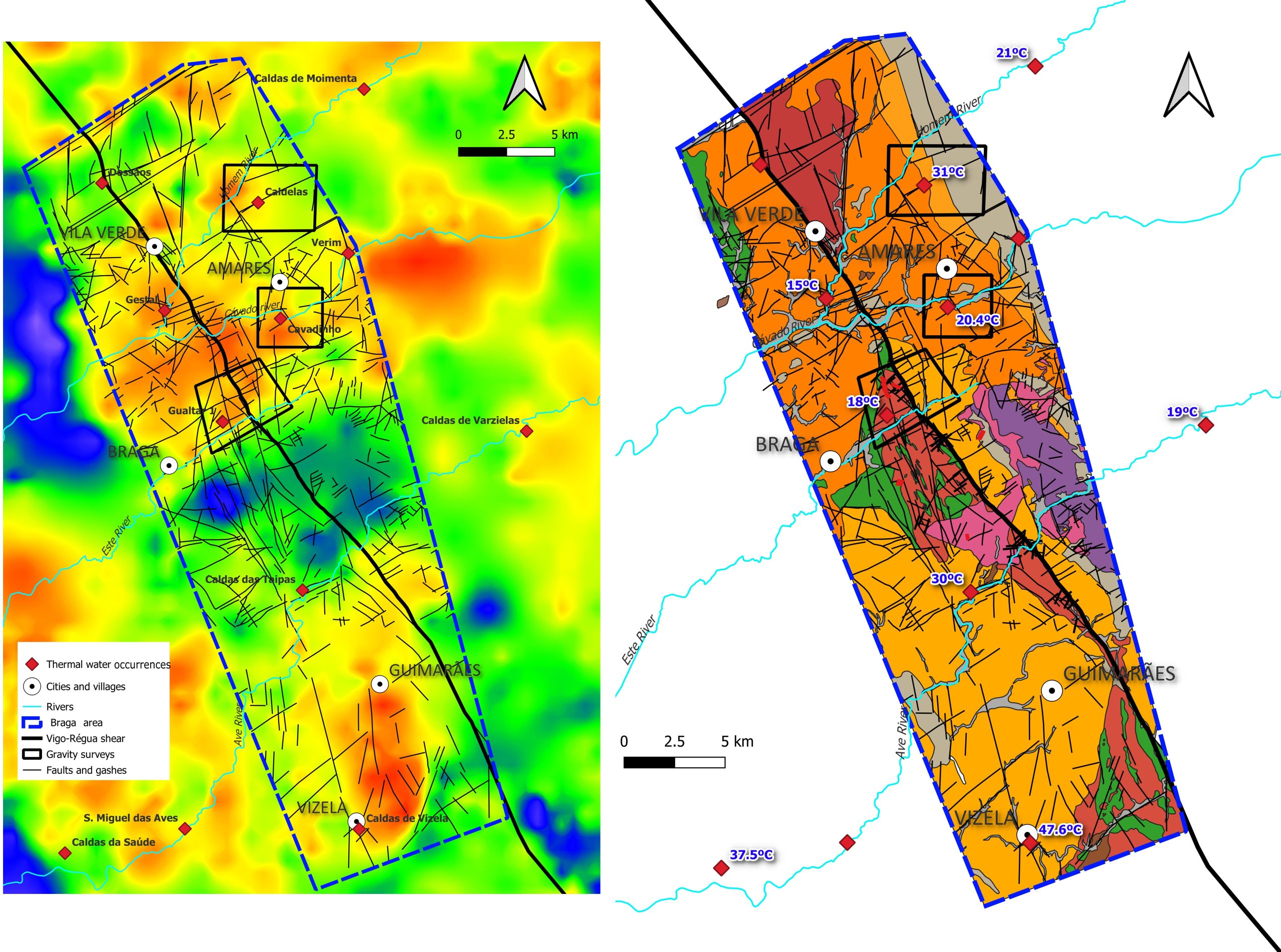
Figure 8: Comparison between radiometric and geological background from the study area and study sites.
The comparison of gravimetric and radiometric data points to the existence of a spatial relationship between the location of thermal water occurrences and radiometric maximum values. Similarly, there is an overlap of the gravimetric anomaly maximum values – indicative of higher density zones – and the radiometric maximum values. Thermal water occurrences are also associated spatially with contrasting zones of high and low gravimetric anomalies. Low radiometric values are associated with granodiorites, leucogranites and metasediments from the area, while high values are mainly related with biotite monzogranites.
5. Discussion
The results generated by the conducted exploratory research, although encouraging, must be viewed with caution. In fact, there are many questions that arise from the obtained results. The scale and detail of the gravimetric and radiometric surveys must be increased in order to show small anomalies related to the outcropping geo-structural data. Also, the scale and definition of the geo-structural mapping must be improved, at least in the already studied sites and in the areas near the thermal water occurrences. The now defined regional exploration guides, which consist of overlapping gravitic lows with radiometric highs and cross-cutting brittle structures in the vicinity of a large polyphasic shear zone, must be thoroughly tested with a refining of geophysical surveys, as well as geological mapping combined with seismic data analysis.
Despite the high annual water recharge of the studied area, there is no consensus concerning the origin of thermal water (e.g. [6], [10], [27]), and our results neither support nor reject the hypothesis of deep-water circulation through tectonic structures, which is the most scientifically accepted. The low gravimetric anomalies surrounding the thermal water occurrences are interpreted as the result of the occurrence of porous/fractured rocks acting as a deep reservoir with a not fully understood origin. The highest radiometric values are probably related to highly radiogenic rocks, a possible source of heat [36]. Thus, these occurrences can be the result of the decay of dense radiogenic rocks with nearby reservoirs induced by the tectonic setting endowed by the Vigo-Régua shear zone and associated faults and gashes. The low radiogenic rocks can act as a cap to the heat generated by the most radiogenic ones.
The temperature range of the selected water occurrences is sufficient to allow electricity generation in binary geothermal power plants [11]. Also, some of the water samples were collected in natural springs and others in boreholes. The comparison of water temperature from boreholes and natural springs allows to state that water temperature increases significantly with depth.
Further studies must be carried out in order to obtain a representative framework of water flow production in these occurrences, which are not known or fully disclosed, mainly the ones that are being currently exploited for balneotherapy and spas.
6. Conclusions
This study was carried out within the Maciço Antigo geotectonic unit in Portugal, focusing on a portion of its Variscan granitic basement which has a geostructural setting that enables the existence of several thermal occurrences. However, the risk of exploration increases considerably in moving away from known hot spring occurrences [36]. There are in-depth geological alteration processes associated with thermal water fluids, unperceived at the surface (non-outcropping), that are detectable through the use of geophysical exploration tools. Local geological singularities will determine the conditions for groundwater circulation and storage. Some parts of the Portuguese territory, namely within its granitic basement, present favourable geostructural indicators for the implementation of stimulated geothermal energy, when compared with other European sites where this technology is being used, despite the large gaps in the detailed knowledge of the underground reservoirs [37].
It is possible to foresee geothermal resource exploration in the vicinities of the deeply rooted Vigo-Régua shear zone, within the Cávado watershed [38], considering the existing data, especially data obtained from geothermometers. However, information on the deep geometry of the Vigo-Régua shear zone and the geothermal fluid circulation mechanisms is scarce. Further research and data collection from combined geostructural, geophysical surveys, hydrogeochemistry and geothermometry of the known regions will allow the determination of drilling targets away from already identified thermal water occurrences and the discovery of geostructural settings favourable for EGS and/or deep geothermal exploration It is also conspicuous that the estimated temperature calculated from geothermometers and from boreholes is much higher than the water temperature measured at the surface (in springs). This situation needs to be clearly understood, especially considering the deep reservoir and its link to the deeply rooted Vigo-Régua shear zone, assumed to be the structure that controls the heat pulses and geothermal circuits by seismic pumping at a regional scale. Also, this will help the identifcation of potentially anomalous geothermal gradients. The tectonic control of thermal water occurrences is evident, as shown by the radiometric and gravimetric anomalies and their relationship to the configuration of regional structures. These indicators, regional structures, and gravimetric and radiometric anomalies may be used as future guides for the exploration of regional geothermal resources.
The potential of the studied area for Enhanced Geothermal Systems (EGS) and/or deep geothermal is plausible, considering the geological setting, thus enabling the production of heat and eventually electricity from this renewable energy source.
Funding: C. Cruz is a contracted researcher under the UIDP/04683/2020 project (Fundação para Ciência e a Tecnologia- Portugal).
Acknowledgments: Bruno Pereira wishes to thank Sinergeo for the opportunity of developing a PhD research project, and also the technical managers of the selected sites. This work was developed under the projects UIDB/04683/2020 and UIDP/ 04683/2020 — ICT, Fundação para a Ciência e Tecnologia (FCT).
References
[1] European Federation of Geologists. Position paper on energy transition. June 2019. Brussels, Belgium. https://eurogeologists.eu/wp-content/uploads/2019/06/EFG-PAPER_energy-transition_20190618.pdf
[2] International Geothermal Association. Best Practices Guide for Geothermal Exploration. IGA Service GmbH Bochum, Germany: Bochum University of Applied Sciences. 2014.
[3] Witter, J., Whitney, J.T-G. & Siler, D. Uncertainty and risk evaluation during the exploration stage of geothermal development: A review. Geothermics 78, 233–242 (2019). https://doi.org/10.1016/j.geothermics.2018.12.011
[4] Miranda, M.M., Rodrigues, N.V., Willis-Richards, J. & Pereira, A.J.S.C. Assessment of deep geothermal energy potential in Northern and Central Portugal; European Geologist 43, 34–39 (2017).
[5] Duque M. R., Santos, F. M. & Mendes Victor, L. Heat flow and deep temperatures in the Chaves Geothermal System, Northern Portugal. Geothermics, 27(1), 75–87 (1998). https://doi.org/10.1016/S0375-6505(97)00023-0
[6] Lima, A.S. Hidrogeologia de Terrenos Graníticos (Minho – Noroeste de Portugal) [Granitic Terrain Hydrogeology], PhD thesis, University of Minho, Braga, Portugal (2001).
[7] Marques, J., Maria J. M., J. B., Carreira P. M., Aires-Barros L.A., & Goff, F. E. Hydrothermal alteration of Hercynian granites, its significance to the evolution of geothermal systems in granitic rocks. Geothermics 39, 152–160 (2010). https://doi.org/10.1016/j.geothermics.2010.03.002
[8] Pinheiro, A.J.A. Ocorrências hidrominerais associadas ao acidente Gerês-Lobios: conceptualização do funcionamento hidrogeológico do sistema hidrotermal. [Hydromineral occurrences associated with the Gerês-Lobios structure: hydromineral system model conceptualization]. Master Thesis, University of Minho, Minho, Portugal (2011).
[9] Guerra, A.C.M. Utilização de isótopos ambientais (2H, 13C, 18O, 3H e 14C) na caracterização de sistemas hidrominerais e geotérmicos do norte de Portugal (Termas de Monção e Gerês). Master Thesis, Instituto Superior Técnico, Lisboa, Portugal (2015).
[10] Correia, A. & Ramalho, E. Heat Flow Density Estimations in the Portuguese Northern Hercynian Massif using Silica Geothermometry. GRC Transactions 33, 921–924 (2009).
[11] Lindal, B. Industrial and other applications of Geothermal Energy. in Geothermal Energy, (ed., Armstead, H.C.H.) 135–148 (UNESCO, 1973).
[12] Trullenque, G. et al. Upscaling of EGS in Different Geological Conditions: a European Perspective. Proceedings, 43rd Workshop on Geothermal Reservoir Engineering, Stanford University, Stanford, California, SGP-TR-213 (2018).
[13] Nicholson, K. Geothermal Fluids: Chemistry and Exploration Techniques (Springer Science & Business Media, 1993).
[14] INE. Consumo de energia elétrica (kWh) por Localização geográfica (NUTS – 2013) e Tipo de consumo [Energy consumption (kWh) by geographical location (NUTS – 2013)]. Annual report. (2021) www.ine.pt (viewed 28/8/2022).
[15] Ribeiro, A., Pereira, E., Ribeiro, M. & Casto, P. Unidades alóctones da região de Morais (Trás-os-Montes Oriental). [Allochthonous units of the Morais Region (Eastern Trás-os-Montes)]. in Geologia de Portugal, Vol. I: Geologia Pré-mesozóica de Portugal (eds. Dias, R., Araújo, A., Terrinha, P. & Kullberg, J.C.) 333–376 (Livraria Escolar Editora, 2013).
[16] Dias, R. & Ribeiro. A. The Ibero-Armorican Arc: a collision effect against an irregular continent? Tectonophysics 246, 113–128 (1995). https://doi.org/10.1016/0040-1951(94)00253-6
[17] Ribeiro, A. et al. Geodynamic evolution of the SW Europe Variscides. Tectonics 26(6), TC6009 (2007). https://doi.org/10.1029/2006TC002058
[18] Noronha, F., Ramos, J.M.F., Rebelo, J. A., Ribeiro, A. & Ribeiro, M. L. Essai de corrélation des phases de déformation hercyniennes dans le Nord-Ouest Péninsulaire [Essay on the correlation of Hercynian deformation phases on the NW of the Peninsula]. Leidse Geologische Mededelingen 52, 87–91 (1979).
[19] Castro, P. et al. Evolução e Estrutura da Zona de Cisalhamento Dúctil Malpica-Lamego: Livro Guia da Excursão pós-congresso.[Ductile shear zone of Malpica-Lamego evolution and structure. Post congress field guide]. VIII Congresso Nacional de Geologia, Braga (eds. Rodrigues, B.C. & Pamplona, J.), 11–12 (2010).
[20] Ferreira, N. et al. Granitóides da Zona Centro Ibérica e seu enquadramento geodinâmico. [Central Iberian Zone Granitoids and their geodynamic setting]. in Geologia de los granitoides y rocas asociadas del Macizo Hespérico [Geology of granitoids and associated rocks of the Hesperic massif] (eds. Bea, F., Carnicero, A., Gonzalo, J.C., Lópes Plaza, M. & Rodriguez Alonso M.D.) 37–51 (Rueda, 1987).
[21] Noronha, F. Rochas graníticas Gerês-Barroso-Cabreira. Suas relações com mineralizações em Sn e W-Mo [Granitic rocks of Gerês-Barroso-Cabreira. Relations with Sn and W-Mo]. (Publicações do Museu e Laboratório Mineralógico e Geológico da Faculdade de Ciências do Porto, 1982).
[22] Dias, G. et al. Geocronologia e petrogénese do plutonismo tardi-varisco, NW de Portugal: síntese e inferências sobre os processos de acreção e reciclagem crustal na Zona Centro-Ibérica [Geochronology and petrogenesis of late-variscan plutonism of NW Portugal]. in Ciências Geológicas: Ensino, Investigação e sua História 143–160 (APG, SGP, 2010).
[23] Agência Portuguesa do Ambiente. Plano de Gestão da Região Hidrografica do Cávado, Ave e Leça (RH2), Parte 2 – Caracterização e diagnóstico da região hidrográfica, [Management plan of the Cávado, Ave and Leça river basins, part 2, Setting and diagnosis] (2015).
[24] Wempe, Y. Application of environmental isotope compositions on geothermal systems in the Cávado river watershed in NW-Portugal. Master thesis, University of Bremen, Germany.
[25] Sinergeo. Trabalhos de prospecção de recursos hidrominerais do concelho de Vila Verde.[Groundwater resources exploration in vila Verde] Internal report, unpublished (2009).
[26] Sinergeo. Prospecção de águas termais no concelho de Braga.[Thermal water prospecting in Braga] Internal report, unpublished (2015).
[27] Calado, C.M.A. A ocorrência de água sulfúrea alcalina no Maciço Hespérico: quadro hidrogeológico e quimiogénese [The occurrence of alkaline sulphuric water in the Hesperic Massif: hydrogeological framework and chemogenesis]. PhD Thesis, University of Lisbon, Portugal (2001).
[28] Ferreira, N., Dias, G., P. de Meireles, C.A.P. &Sequeira Braga, M.A. Folha 5-D Braga na escala de 1:50000. [Sheet 5-D of the Portuguese Geological Map in 1:50,000 scale] 2ª edição. (Departamento de Geologia. Instituto Geológico e Mineiro., 2000).
[29] Teixeira, C., Medeiros, A.C. & Lopes, J.T.,Folha 5-B Ponte da Barca na escala 1:50000 da Carta Geológica de Portugal. [Sheet 5-B of the Portuguese Geological Map in 1:50,000 scale] (Direcção Geral de Minas e Serviços Geológicos, 1974.).
[30] Andrade, M.M., Noronha, F. & Rocha, A.. Folha 9-B Guimarães na escala 1:50000 da carta Geológica de Portugal. [Sheet 9-B of the Portuguese Geological Map in 1:50,000 scale] (Direcção Geral de Geologia e Minas. Serviços Geológicos de Portugal, 1986)
[31] Dentith, M. & Mudge, S. Geophysics for the Mineral Exploration Geoscientist. (Cambridge University Press, 2014).
[32] McCay, A.T., Harley, T.L., Younger, P.L., Sanderson, D.C.W. & Cresswell, A.J. Gamma-ray Spectrometry in Geothermal Exploration: State of the Art Techniques. Energies 7, 4757–4780 (2014). https://doi.org/10.3390/en7084757
[33] Batista, M. J., Torres, L., Leote, J., Prazeres, C., Saraiva, J. & Carvalho, J. Carta Radiométrica de Portugal (1:500 000). [Portuguese Radiometric Map 1:500000]. (Laboratório de Energia e Geologia, 2013)
[34] Angélico, M. Geofísica Aplicada à prospecção geológica, Estudo Gravimétrico em Contexto granítico no Concelho de Amares [Applied geophysics. Gravimetric study in a granitic context in Amares]. Master Thesis, FCUP-University of Porto, Portugal (2019).
[35] Rolo, R. Geofísica Aplicada a Prospeção Geológica-Estudo Gravimétrico de carácter exploratório em zonas com potencial geotérmico (Região de Braga) [Applied Geophysics and exploratory gravimetric study in zones with geothermal potential (Braga Region)]. Master Thesis, FCUP-University of Porto , Portugal (2021).
[36] Neves, L., Pereira, A. & Dias, J.M. Os Sistemas Geotérmicos Estimulados (EGS/HDR): um desafio para o século XXI. [Enhanced Geothermal Systems (EGS/HDR): a challenge for the 21st century]. in Modelação de Sistemas Geológicos: Livro de Homenagem ao Professor Manuel Maria Godinho (eds. Neves, L.J.P.F., Periera, A.J.S.C., Gomes, C.S.R. & Tavares, A.O.) 277–290 (Coimbra University Press, 2011).
[37] Carvalho, J.M. Prospecção e pesquisa de recursos hídricos subterrâneos no Maciço Antigo Português: linhas metodológicas. [Exploration of groundwater in the Portuguese Old Massif: methodological guidelines]. PhD Thesis, University of Aveiro, Portugal (2006).
[38] Pereira, B., et al. Recursos Geotérmicos na Região Noroeste de Portugal: Avaliação Exploratória em Sectores dos Rios Cávado e Ave [Geothermal Resources in the Northwestern Region of Portugal: Exploratory Assessment in Sectors of the Cávado and Ave Rivers]. 13º Seminário sobre Águas Subterrâneas-APRH, 28–29 April 2022.
This article has been published in European Geologist Journal 54 – Geothermal energy – A geological contribution to the energy transition
Read here the full issue:
