
European Geologist Journal 53
Pan-European geological data, information, and knowledge for a resilient, sustainable, and collaborative future
by Julie Hollis1, Stephanie Bricker2, Dana Čápová3, Klaus Hinsby4, Hans-Georg Krenmayr5, Phillippe Negrel6, Daniel Oliveira7, Eleftheria Poyiadji8, Serge van Gessel9, Sytze van Heteren9, Guri Venvik10
1EuroGeoSurveys, Rue Joseph II 36/38, 1000, Brussels, Belgium
2British Geological Survey, Environmental Science Centre, Keyworth, Nottingham NG12 5GG, UK
3Česká geologická služba/Czech Geological Survey, Division of Information Systems, Kostelní 26, 170 06 Praha 7, Czech Republic
4Geological Survey of Denmark and Greenland, Øster Voldgade 10, 1350 Copenhagen K, Denmark
5Geological Survey of Austria, Neulinggasse 38, 1030 Vienna
6BRGM, 45060 Orléans, France
7Laboratório Nacional de Energia e Geologia, Mineral Resources and Geophysics Research Unit, Estrada da Portela, Bairro do Zambujal – Alfragide, Apartado 7586, 2610-999 Amadora, Portugal
8Hellenic Survey of Geology and Mineral Exploration, Department of Natural and Technological Hazards Management, 1 Sp. Louis Str., Olympic Village, Acharnes, Greece, GR-136 77
9TNO – Geological Survey of the Netherlands, P.O. Box 80015, 3508 TA Utrecht, the Netherlands
10Geological Survey of Norway, 7491 Trondheim, Norway
Contact: julie.hollis@eurogeosurveys.org
Abstract
Many fields of research relevant to climate-change-related policy are grounded in geological sciences – far more than is generally recognised by the public or policy makers. These fields include management of marine environments, urban development, groundwater, landslide risk, understanding the geochemistry of soils and water, and securing raw materials. Through the concerted collaborative efforts, over many years, of EuroGeoSurveys – the Geological Surveys of Europe – national datasets bearing on these and other areas have been harmonised at European scale and delivered through an online digital platform, the European Geological Data Infrastructure. This vast store of baseline data, information, and knowledge is crucial for informed pan-European decision making and is considered the core of a future Geological Service for Europe.
Cite as: Hollis, Julie, Bricker, Stephanie, Čápová, Dana, Hinsby, Klaus, Krenmayr, Hans-Georg, Negrel, Philippe, Oliveira, Daniel, Poyiadji, Eleftheria, van Gessel, Serge, van Heteren, Sytze, & Venvik, Guri. (2022). Pan-European geological data, information, and knowledge for a resilient, sustainable, and collaborative future. European Geologist, 53, 6–19. https://doi.org/10.5281/zenodo.6883282

This work is licensed under a Creative Commons Attribution 4.0 International License.
Introduction – a foundational geological data infrastructure
Climate change is generating sharp changes in environmental conditions on geologically short time scales, requiring decision-making that is resilient in the face of such rapid changes at local to Pan-European and even global scale. Key to developing resilient decision-making that protects society and nature (Lewis and Maslin, 2015; Steffen et al., 2018), and keeps Earth within planetary boundaries (Steffen et al., 2015; Lade et al. 2020) is the digital infrastructure and data that will support the EU’s goal of climate neutrality by 2050, the Green Deal (European Commission, 2022), and the UN sustainable development goals (United Nations, 2022). Easy and efficient access to digital data is crucial for: i) prioritising competing uses of the subsurface, ii) sustainable use of subsurface resources, iii) integrated surface and subsurface spatial planning, iv) sustainable use of groundwater as a crucial part of the hydrological cycle connecting surface and subsurface freshwater resources (Gleeson et al., 2020), and v) adaptation to climate-related extreme events (Quevauviller, 2022). The EU’s digital strategy aims to strengthen its digital sovereignty and set standards, with a clear focus on data, technology, and infrastructure. One important component of the required digital data and data infrastructure is geological data, which can directly inform on such diverse climate-impacted areas as our changing urban and built environments (including infrastructure such as railways and roads), risk of landslides and land subsidence, agriculture and food, clean water, ecosystems and biodiversity, and the development of sustainable and renewable energy and clean technologies, honouring the water-energy-food nexus (Bazilian et al., 2011; de Roo et al., 2020). It is also crucial that these data are accessible, current, and harmonised at European scale and include near real-time data for early warning of events that will have significant societal impacts, such as combined groundwater and surface water flooding following climate-related extreme events (Hughes et al., 2011; Quevauviller, 2022).
The need for up-to-date pan-European geological data that is findable, accessible, interoperable and reusable (FAIR, Wilkinson et al., 2016) has been addressed by EuroGeoSurveys (EGS) by developing a common sustainable European Geological Data Infrastructure (EGDI, 2022). The main priority is to provide the European Commission and other users with high quality, trusted, borderless, digital public services, facilitating free access to multinational geological data, monitoring and modelling results and harmonised data, information and knowledge at European level – data that are derived from the Geological Survey Organisations’ national databases and that are of high value when assessing current and future climate change impacts. Great efforts by EGS are being made to harmonise and make use of a large variety of important geological data in new and innovative ways and make the data available in accordance with INSPIRE and other relevant standards.
For almost two decades, EGS members have collaborated within many EU projects focused on harmonisation of geological data across Europe. In 2014, an analysis showed that the EU had funded geological data harmonisation projects, providing support of several hundred thousands of euros, but that only a small fraction of the results were still available online, a few years after the projects had ended. EGS therefore decided to establish EGDI, first launched in 2016. The first version consisted of a web GIS, dedicated GIS viewers for specific geological topics, numerous distributed web services, a metadata catalogue, and a database of pan-European harvested data. It gave access to over 600 layers from 13 projects. EGDI has since provided a pipeline of data, information, and knowledge through which the geological surveys connect strategically and technically with the wider European Research and Digital landscape. In 2018, the Horizon 2020 ERA-NET on Applied Geosciences (GeoERA) was launched with 15 projects, including an information platform project developing common map viewers for the 14 projects within geoenergy, groundwater and raw materials and generating many local to pan-European datasets (EGDI, 2022). EGDI is the platform to safeguard, harmonise and disseminate all of this information. Through a dedicated project in the GeoERA program (GIP-P), EGDI significantly expanded to include a document repository, a search system, a 3D database, vocabularies, a user-support system and eLearning platform. When GeoERA ended in October 2021, EGDI made available the results from a total of 37 projects covering on- and offshore geology, raw materials, geoenergy, groundwater, geohazards, geochemistry and geophysics.
Future plans focus on the further development of EGDI into a knowledge infrastructure, continuing the harmonisation and standardisation effort, but also innovation around how subsurface information is processed. Improving the accessibility and quality of the results of future geological research will ensure the usability and long-term sustainability of the EGDI. Data and services will also connect EGDI to other infrastructures (e.g. EMODnet, EPOS, WISE), bringing geological data, information, and knowledge to other domains and vice versa.
The ultimate goal of this EGS work is to establish a subsurface knowledge network that provides useful and up-to-date information to decision-makers and the scientific community, and that feeds European data platforms. Furthermore, this network is open for collaboration with stakeholders to further build the infrastructure, through the addition of data and interpretations. The network will be the cornerstone of the Geological Service for Europe – a collaborative effort and vision of the European Geological Surveys through EGS. To achieve this goal, the quality and reliability of the data and information (the content) needs to be ensured and the technical infrastructure (EGDI) underlying the data and information must be kept up to date. To ensure the accuracy and timeliness of EGDI content, a permanent network of thematic experts from Geological Survey Organisations will be organised, focusing on the systematic creation, control and continuous updating of information, metadata and data in EGDI in collaboration with stakeholders. In this contribution, we present examples of the combined efforts of EGS through GeoERA and other projects, covering diverse geological disciplines relevant to public policy-making, and delivered through EGDI.
Marine management
Since 2009 all of Europe’s geologic surveys involved in seabed mapping have worked together in producing accessible and harmonised data and data products on the seabed surface, its shallow subsurface, seabed geomorphology, coastal behaviour, marine-geological events, hydrocarbon and mineral resources, and submerged landscapes. These data are provided through the EMODnet Geology portal, developed though participation of the EGS’ Marine Geology Expert Group (MGEG) in the European Marine Observation and Data network (Vallius et al., 2020; Moses and Vallius, 2020).
The work of MGEG fits neatly within Europe’s aim to be the first climate-neutral continent. In support of Blue Growth and the Biodiversity Strategy, reliable maps of the surficial seabed substrate provide Europe with information on habitat suitability. They help explain the location of benthic species and communities and predict where they could thrive (Kaskela et al., 2019). The deeper geology of the seafloor subsurface is critically important in decarbonising the energy sector (Guinan et al., 2020). It determines how suitable an offshore area is for wind-turbine foundations, for trenching energy cables, and for capturing carbon. The Strategy on Adaptation to Climate Change relies on knowledge of coastal behaviour and expertise on geohazards at the land-sea boundary. Awareness mapping identifies areas with specific geological conditions that may render them susceptible to unwanted effects of climate change (Ryabchuk et al., 2020). Awareness mapping is also needed to optimise preventive and remedial coastal-zone management policies. We especially need reliable data and expertise to prioritise conflicting use of the subsea. Aggregates and marine minerals are necessary for the energy transition, but minimising the environmental impact of their extraction requires broad-scale information allowing policy makers to make those prioritisations (Terrinha et al., 2019). Study of the marine environment also allows us to learn from the past. In mapping drowned European landscapes, we may discover, for instance, how sea-level rise affected Stone Age societies: adaptation to climate change is not a concept invented in the twentieth century.
Importantly, EMODnet Geology is embedded in a broader programme that addresses bathymetry, biology, chemistry, human activities, physics, and seabed habitats (Martín Míguez et al., 2019). These disciplines have been pooling their knowledge and resources. One example is the digital terrain model of EMODnet Bathymetry, which has been instrumental in generating a geological data product on geomorphology that interprets the purely descriptive water-depth model in terms of formative processes and anticipated future behaviour. Adding these explanatory and predictive elements is a key step forward. The ecological significance of geological information on the seabed substrate has helped EMODnet Seabed Habitats achieve their pan-European aspirations. Due to much better coverage of geological than biological information, rock and sediment type are the proxy of choice in modern-day marine habitat mapping (Figure 1). These and other success stories stimulate further cooperation. They also show policy makers and other end users the added value of joint output, as illustrated and facilitated by the Commission’s European Atlas of the Seas.

Figure 1: Portal view of EMODnet Geology map (Map viewer – Geology (emodnet-geology.eu)), showing type of sediment or rock exposed at the seabed.
Urban management
Europe is a highly urbanised region with urban populations ranging from 55% in e.g. Slovakia, up to 98% in Belgium. With high urban populations, increased urban expansion and densification of services, Europe’s towns and cities are increasingly vulnerable to climate risks: urgent action is demanded to mitigate and adapt to the impacts of climate change. UN Sustainable Development Goal (SDG) 11 (Sustainable Cities and Communities) and the New Urban Agenda (United Nations, 2017) are clear in their ambition for towns and cities to fulfil their social and ecological functions, and to be resilient and sustainable in an uncertain climatic future. Urban geology – at the intersection of natural-built-social systems – and wider management of urban underground space are critical in the delivery of SDG 11 and climate adaptation measures (Admiraal and Cornaro, 2016). Delivering climate-resilient cities will, however, place competing demands on subsurface natural systems and resources, whether the space is utilised as a shallow geothermal energy source, to provide energy storage and house urban heat networks, to support urban green-blue infrastructure, to maximise the infiltration of water to the ground through sustainable drainage systems, or to provide cool spaces underground as urban temperatures rise (Bricker, 2021). This is reflected in the priority urban geology topics identified by EGS, including low-carbon energy, resource optimisation, nature-based solutions, hazard and risk management, and digital data workflows.
Addressing these needs, geologists across Europe have been working in collaboration with urban planners across 24 countries, initially through the EU COST Sub-Urban Action (van der Meulen et al., 2016), to ensure that geological data, evidence, and information are embedded in urban planning and place-making. A recent survey (2020) of 20 of the EGS member geological surveys shows that all provide geological datasets suitable for application at the urban scale (1:50,000 or larger scale). Fifteen countries offer 10 or more urban-scale geological datasets (e.g. hydrogeology maps, subsidence hazard, geoheritage sites), with some offering bespoke urban planning packs or data tools such as maps showing suitable locations for sustainable urban drainage systems (SuDS) (Dearden et al., 2013). Seventy per cent of the geological surveys undertake 3D urban geological modelling. Over and above data provision, the Sub-Urban Action focused on the development of good practice guidance in relation to subsurface planning, data management, 3D modelling, urban groundwater and geothermal systems, and geochemical mapping. Bridging the gap between planners and subsurface specialists (Dick et al., 2017), geologists demonstrated the value of having an integrated 3D urban ground information model, which provides an enhanced understanding of the geological character and physical properties of the ground. This underpins a subsurface masterplan and identifies options for resilient land uses such as nature-based solutions. Applying these geological data-models, geologists in partnership with urban practitioners have, e.g., evaluated the effectiveness of SuDS for flood management (Archer et al., 2020; Lentini et al., 2021) and investigated the use of SuDS to help stabilise groundwater levels and lower subsidence risk (Venvik et al., 2020). Urban planners have used the enhanced subsurface understanding to realise the multiple environmental and socio-economic benefits of SuDS (BiTC, 2018) and implement nature-based climate adaption measures (e.g. Connectingnature.eu/Glasgow).
The lack of legislation at both national and European level creates challenges for the management of the subsurface (Volchko et al., 2020). Although the geological subsurface is diverse across Europe, the human needs and the facilities inserted into the subsurface are common, such as tunnels, parking, etc. A unified, pan-European understanding of subsurface FAIR-data would promote the goal of data-driven decision making and the possibility for Digital Twins. An example is the EU Water Framework Directive (Water Framework Directive, 2000) upon which a subsurface framework could be based. Although time-consuming to co-ordinate and implement, common legislation regarding the quality and quantity of waterbodies, above and below ground, has been successfully implemented across Europe. Similar directives concerning the subsurface, especially in cities, would enhance data recovery and re-use, thereby reducing risks and making cities more resilient.
Sustainable Geo-Energy Resources and Capacities
Energy is vital to almost all aspects of our society, such as heating our homes, producing food and resources, manufacturing feedstock and derived products, transport, serving our ever-growing digital needs and much more. However, our energy consumption poses two major challenges. On the one hand, our huge dependency on fossil fuels (oil, natural gas, and coal) leads to rising atmospheric CO2 concentrations and subsequent climate change. On the other hand, there is a decline in domestic energy production and, as a result, we become more dependent on suppliers outside Europe. These challenges, among others, are addressed in the European Green Deal agenda by increasing our capacities for domestic renewable energy generation, reducing energy consumption and preventing emissions of CO2 and other greenhouse gases. The subsurface provides capacities and possibilities that match the scale of society’s needs. The main technology options are:
- Shallow and deep geothermal energy to support low-carbon heating demand in the built environment, agricultural sector, industry sector and power generation sector.
- Storage of CO2, which is essentially the only option to effectively reduce emissions while we are still dependent on fossil fuels and to enable negative emissions in combination with low-carbon energy generation
- Storage of sustainable energy carriers in the form of hydrogen, green gas, heat and cold, compressed air, and other mechanical forms of energy. This is needed to balance increasing shares of variable renewable energy (wind/solar) against seasonal consumption, increase renewable energy efficiency and secure affordable energy in periods of supply disruption (e.g. reduce potential economic impacts from extremely high energy prices or energy shortages in industry).
- Domestic production of natural gas is still regarded as important to bridge the energy transition during the coming decades and to slow down our increasing import dependency.
Six GeoERA Energy projects deliver FAIR information, harmonised methodologies, and strategies for identifying, managing and responsibly developing the above resources. The main objectives and scope included (i) harmonised prediction of geo-energy resources and storage capacities; (ii) identification of synergies and potential bottlenecks, such as hazards and environmental impacts; (iii) deployment of geological information in state-of-art decision support and subsurface management and planning tools; and (iv) improved dialogue with stakeholders, societal organisations and the public. The following projects have successfully contributed to these objectives:
- MUSE – A novel information platform and stakeholder tools to enable and responsibly manage and deploy shallow geothermal potential in urban areas
- Hotlime – Harmonised methods and information to unravel the potential for development of deep geothermal plays in Europe and reduction of exploration risks
- GARAH – Capitalising on information and knowledge from the Oil & Gas industry to unlock the hydrocarbon potential in EU seas and options for CO2 and energy storage
- HIKE – A new state-of-art database for analysing and disseminating information on faults, including methods to assess hazards and impacts from geo-energy uses
- 3DGEO-EU – State-of-the-art methods and strategies that pave the way towards a harmonised 3D digital twin of Europe’s geology and subsurface energy resources
- GeoConnect3d – A first-of-its-kind framework and tools to support subsurface management and stakeholder dialogues, focusing on different themes including geo-energy uses.
The GeoERA Energy projects deliver a stepping stone for the upcoming Geological Service for Europe, which will focus on developing key knowledge and pan-European databases and atlases that will extend the knowledge and information base to responsibly unlock and develop geothermal energy, permanent storage of CO2 and temporary storage of sustainable energy carriers.
Water Resources
Sufficient groundwater of good quality is extremely important for societies, ecosystems, and biodiversity and the Water Framework and Groundwater directives stipulate that all EU member states must assess and report the status of European groundwater bodies (European Environment Agency, 2022). The groundwater chemical and quantitative status must be assessed based on good status objectives for legitimate uses (e.g. drinking water) and groundwater dependent terrestrial and aquatic ecosystems including coastal and marine waters (Hinsby et al., 2008, 2011, 2012). Too much or too little water endangers food production, biodiversity, the built environment, and may result in floods, droughts, landslides, land subsidence, and other geohazards. Migration of polluted groundwater may also jeopardise the quality of even deeper aquifers supplying old pristine drinking water to European citizens (Broers et al., 2021; Hinsby et al., 2001); and salt water intrusion into coastal aquifers may do the same (Hinsby et al., 2011; Werner et al., 2013).
In the GeoERA programme, the Water Resources Expert Group (WREG) of EGS investigated groundwater quantity and quality issues related to natural processes, human activities, and climate change (GeoERA, 2022). The aim was to improve the basis for informed decision-making regarding protection of, or related to, (i) groundwater quantitative and chemical status; (ii) groundwater legitimate uses; (iii) groundwater-dependent terrestrial and associated aquatic ecosystems and biodiversity; (iv) the groundwater ecosystem itself; (v) ecosystem services; and (vi) climate and global change mitigation and adaptation. The GeoERA groundwater projects provide new, important FAIR data, accessible through EGDI for improved water resources management in Europe. This data will improve our understanding of the subsurface and is being used to develop efficient tools, e.g. for water resources mapping, monitoring and modelling, climate change impact assessment, mitigation and adaptation. The groundwater projects were:
- HOVER – “Hydrogeological processes and geological settings over Europe controlling dissolved geogenic and anthropogenic elements in groundwater.”
- RESOURCE – “Resources of groundwater, harmonised at cross-border and pan-European Scale,” including integrated studies in two transboundary aquifer settings, Belgium-Germany-the Netherlands and Poland-Lithuania, and a new pan-European groundwater resources map that includes information on volumes, age and quality (salinity).
- TACTIC – “Tools for assessment of climate change impact on groundwater and adaptation strategies,” including e.g. a pan-European groundwater recharge map (Figure 2), projections of groundwater levels in different climate scenarios, and salt water intrusion issues in coastal aquifers
- VoGERA – “Vulnerability of shallow groundwater resources to deep sub-surface energy-related activities,” including a decision support tool/Excel workbook for vulnerability assessments available via the VoGERA map viewer on EGDI and a range of conceptual models relevant for these assessments.
The main impacts and services of the four GeoERA groundwater projects include: improved access to downloadable groundwater quantity and quality data on a local to pan-European scale; state-of-the-art tools to support sustainable decision making in relation to the water-food-energy-ecosystem nexus; tools for assessment of climate change impacts; mitigation and adaptation strategies, drought and flood risks, etc. (Figure 2); and opportunities for private companies and research institutions to collaborate and develop new groundwater add-on services to EGDI. The data and tools provide valuable information and assessments for EU and UN policy implementation and development including the European Green Deal (European Commission, 2022), the UN Sustainable Development Goals (United Nations, 2022) and the UN Framework Classification for Groundwater, which is included in the new UN Resource Management System together with framework classifications for other subsurface resources, etc. (UNECE 2021a, b).

Figure 2: Long-term average pan-European potential groundwater recharge map (1981–2010) developed based on local and national recharge estimates, satellite data (e.g. Stisen et al., 2021) and machine learning (Martinsen et al., 2022) (note that Cyprus is included in the inset, bottom right). The data are relevant for (e.g.) integrated groundwater-surface water models simulating and assessing climate change impacts on European water resources, future risk of groundwater and surface water flooding, nutrient loadings to groundwater and associated aquatic ecosystems (Hinsby et al., 2008, 2012), and assessments of climate change impacts on the water-energy-food-ecosystem nexus (WEFE, 2019).
Landslide risk
Geohazards (geology-related natural hazards) have great socioeconomic impact and are being addressed by the Sendai Framework for Disaster Risk Reduction 2015–2030 (United Nations, 2015). Although many geohazards, such as earthquakes, are widely recognised and people are aware of seismic risk, this is not the case for a large subcategory of geohazards – those related to ground instability: landslides, subsidence, and sinkholes. A pan-European database and the resulting maps could certainly help landslide hazard management on European, national, and regional scales, being also useful to perform multi-hazard analysis in areas with high seismic hazard. For this reason, in 2017, the Earth Observation and Geohazards Expert Group (EOEG) of EGS analysed the landslide databases of the Geological Surveys of Europe (Herrera et al., 2017), focussing on their completeness and interoperability.
A total of 849,543 landslide records for 24 countries were classified as slides (36%), falls (10%), flows (20%), complex slides (11%), and others (24%). The majority of records for each landslide type are mapped with the same features at 1:25,000 or greater, allowing generation of European-scale maps for each landslide type. However, the locational accuracy of every landslide has not been evaluated using the same procedure and should be harmonised (e.g., using the procedure of BRGM, BGS or ISPRA). Based on the additional information available for most of the landslide databases, the European-scale susceptibility assessment for each landslide type seems justified. However, information necessary for hazard and risk analysis is scarce (<40%) and heterogeneously distributed across countries. Therefore, European-scale hazard and risk assessments are difficult to achieve.
A landslide density map was produced (Figure 3) showing, for the first time, 210,544 km2 of landslide-prone areas in Europe. A comparison of the LANDEN map (Figure 3) with the European landslide susceptibility map (ELSUS 1000 v1) highlights gaps in the existing landslide databases and the variable landslide strategies adopted across Europe. In some countries, landslide mapping is systematic. In others, only damaging landslides are recorded. In others still, landslide maps are only available for certain regions or local areas. Moreover, in most countries landslide databases from the Geological Surveys co-exist with others (at variable scales and formats) managed by a variety of public institutions.
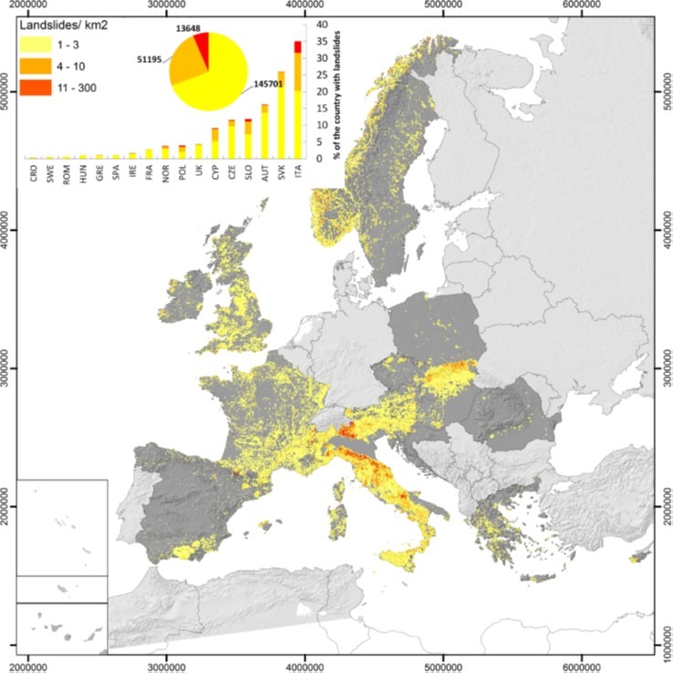
Figure 3: The LANDEN map – a landslide density map for Europe, based on landslide data from 24 countries and showing 210,544 km2 of landslide-prone areas.
Another survey carried out among twenty-one national and eight regional Geological Surveys analysed existing legislation across European countries related to the integration of landslide hazard into urban planning (Mateos et al., 2020). The survey revealed that almost half of the ten participating countries have no legal guidance in the National Land Bill to stipulate consideration of landslides in urban planning practices, and mapping tools are often not adapted to a standard required to inform sustainable development. Furthermore, the analysis showed that there is a wide range of laws and large heterogeneity in mapping methods, scales and procedures. A relevant deficiency detected in many countries is the lack of landslide maps at a detailed resolution for urban planning.
To assess the impact of landslide hazard in Europe, EOEG gathered information from the geological surveys and created an inventory and database of damaging landslides for a three-year period (2015–2017). The data focused on just few related parameters, as the purpose was to understand triggering factors and impacts on European countries: landslide typology; spatial distribution; triggering factor; fatalities and injuries; and damages. For this three-year period, 3,846 damaging landslides occurred in 19 European countries, including Switzerland and Ukraine (but not Denmark, Germany, Norway, Slovakia or Sweden). 143 landslides caused 39 fatalities and 155 people were injured. Most landslides (69%) were triggered by episodes of intense or long-lasting rainfall, or both. Croatia, Greece, and Italy recorded 43 landslides triggered by earthquakes (1.1% of the total). For the remainder (around 30%), the triggering factor is either not registered (some countries do not keep records of triggering factors) or unknown (Mateos et al., 2020).
If we consider that more intense floods and storms will result from climate change (European Environment Agency, 2021), the number of landslides will also increase. There are many documented European cases of long rainy periods that triggered many landslides over large areas (Multiple Occurrence Regional Landslide Events, or MORLEs, defined by Crozier, 2005). An example of this abnormal situation took place on Mallorca (Spain) in the period 2008–2010, when a combination of persistent precipitation and low temperature caused an unusual number of slope failures. This had a great impact on the regional economy, which revolves exclusively around tourism (Mateos et al., 2012). 18 MORLEs during the past 10 years were reported by 11 Geological Surveys (Mateos et al., 2020), with a total of approximately 150 fatalities and severe economic impacts. Most MORLEs are related to extreme rainfall episodes, and usually associated with other major natural disasters, such as flooding. MORLEs are not well recognised publicly and the media overlook their effects. Meanwhile, landslide risk, and MORLEs, will increase due to climate change, making the management of events more difficult as the civil protection authorities will have to cope with concurrent landslides affecting large areas.
Soil geochemistry
Regional geochemical mapping highlights continental scale anomalies or patterns in surface- or groundwater and soil. Such maps (derived from geochemical surveys) provide invaluable information about natural and human-induced concentrations of chemical elements in the near-surface environment (Demetriades et al., 2010). This is known as the ‘critical zone’, where we live, grow crops, raise livestock, and from which we extract our drinking water, and other raw materials, including mineral wealth. To recognise and understand changes in natural systems, we need well-characterised and current knowledge of a range of baseline levels.
Collaborative efforts to geochemically map Europe have been ongoing for decades through EGS and its precursor organisations. Geochemical mapping on the European scale started in 1985 when the WEGS (Western European Geological Surveys) established a Working Group on “Regional Geochemical Mapping”, succeeded by the Geochemistry Task Group implemented by the FOREGS (Forum of European Geological Surveys) in 1993. Geochemical baselines were urgently needed in Europe at that time because environmental authorities in most countries were defining limits for contaminants in soils for different land use purposes and to contribute to the preparation of the future EU Soil Protection Directive (European Commission, 2002, 2006). Based on stream water, stream sediment, topsoil (0–25 cm), subsoil (>75 cm) and floodplain sediment samples from approximately 800 drainage basins within 26 countries and an area of 4.25 million km2 in Europe, the geochemical mapping of Europe project from FOREGS was carried out from 1997 to 2006. This yielded the first geochemical atlas of Europe (Salminen et al., 2005; De Vos, Tarvainen et al., 2006), a harmonised pan-European or Global geochemical ‘baseline’. Between 2008 and 2014, the EGS Geochemistry Expert Group (GEG) conducted the GEochemical Mapping of Agricultural and grazing land Soil (GEMAS) project, covering 33 European countries and an area of 5.6 million km2 (Reimann et al., 2014a, b). GEMAS documents, for the first time, the concentration of almost 60 chemical elements, and the parameters determining their availability and binding in agricultural and grazing land soils at the scale of a continent. In GEMAS, the two different sample materials, ploughed soil (0–20 cm) and grazing land soil (0–10 cm), taken at different locations at a density of 1 site/2500 km2 across Europe, deliver very comparable distribution maps for most elements. The results confirm that low sample density mapping results in robust geochemical maps. Natural and/or anthropogenic origins for the elements in the soils can be investigated at the continental scale (Reimann et al., 2018), as is now realised over other continents (Smith et al., 2013; Wang et al., 2015; Reimann and Caritat, 2017). For such continental scale mapping, a high quality geochemical baseline data must be established, requiring standardised sampling, sample preparation and analytical methodologies to obtain a consistent and harmonised dataset. This was done for the GEMAS project, giving for the first time more than 50 chemical element concentrations and physical properties.
Geology, i.e. the rocks from which the soils were derived, plays a key role in determining the map patterns. Many chemical elements are dominated by anomalies related to single ore deposits or metal provinces. Soil developed on the sediments of the last glaciation, on chalk and limestone, granite, alkaline intrusions, greenstone or black shale, all have their own geochemical signature that can be detected on the maps. As examples, silicon in the agricultural soil samples displays high concentrations in northern central Europe, over the thick silica-rich sediments of the last glaciation, whereas calcium displays high concentrations over areas underlain by chalk and limestone, mainly in southern Europe (Figure 4).
 Figure 4: Geochemical map for (a) Si and (b) Ca total concentrations in ploughed agricultural soil (Ap, n=2108) (XRF results). Interpolation by kriging, range = 1,000 km, and search radius = 300 km. Modified from Reimann et al. (2014a, b).
The elements associated with human activities are marked by elevated element concentrations in the agricultural soil samples taken in the vicinity of some big European cities (e.g. London, Paris, Rotterdam) and in some cases also small ones (e.g. Verdun, in France, is marked by a high lead anomaly due to material derived from World War One battles). However, an anthropogenic impact is difficult to detect at the mapping scale of the GEMAS project. The locations of most metal smelters or coal fired power plants, for instance, remain invisible on the maps. Many of the high values observed are actually related to natural metal occurrences or to specific rock types that are enriched in these elements. The human impact on the quality of the agricultural soils remains low at the continental scale.
Many trace elements are important for the health of plants, animals and humans. While very few soil samples reach concentrations where toxicity may become a concern, more than 10% of the samples contain such low concentrations of certain elements that deficiency is an issue for optimum plant and animal health and productivity – possibly an issue warranting significant attention at European scale.
GEMAS approaches soil geochemistry from different perspectives. In addition to the approach based on the interest of the elements studied (e.g. pollutants, nutrients, natural resources, role of climate), the weathering processes from rock to soil, the health aspects via the presence or absence of certain elements, or even the approach of the very recent criticality assessment of certain elements are at the heart of GEMAS. This geochemical atlas at the European scale, with the low-density approach, can be used for effective land use planning, e.g. prioritisation and management of mineral exploration, agriculture and forestry, animal husbandry, land use and environmental policies, health-related research, and construction adaptation of towns. Policy, which plays a key role, is becoming more holistic and the trend is to address the whole soil system, for which these baseline data are fundamental.
Minerals and critical raw materials
The 19th and 20th centuries saw a shift from agrarian to industrialised societies, together with a growing world population and changing consumption patterns. These led to increasing global demand for raw materials. Today, non-energy minerals underpin modern economies, being essential for manufacturing and renewable energy (e.g., Commission of the European Communities (2008); de Oliveira et al., 2020a, 2020b, 2021; Wittenberg et al., 2020a, 2020b; IEA, 2021), and domestic production is a key factor in improving the security of supply of raw materials to the EU (European Commission, 2018). Projections of future trends indicate that resource use could double between 2010 and 2030, mostly driven by demand in developing regions (European Commission, 2016). And while the EC’s Blue Growth strategy estimated that by 2030, 5% of the world’s minerals, including cobalt, copper and zinc, could come from a new region – the ocean floors (SWD(2017) 128 final) – the crucial question is whether supply is adequate to meet future demands. Access to sustainable mineral resources is key for the EU’s resilience in achieving the goals of the EU Green Deal. Achieving resource security requires action to diversify supply from both primary and secondary sources, reducing dependencies and improving efficiency and circularity, including sustainable product design. This is true for all raw materials but is vital for those raw materials that are considered critical for the EU.
Access to mineral resources is only possible with risky, long-term investments in exploration and a reliable knowledge base. The stronger and more complete the knowledge base, the less risky investments and decision-making processes become. Across Europe, significant investments have been made in building the foundations of this knowledge base with several collaborative key EGS projects, delivering accurate and homogenised data. Efforts commenced with EuroGeoSource; the first EU data platform that delved into the complex issue of INSPIRE compliancy, followed by Minerals4EU. The latter led to the first European homogenised dataset, followed by the MINTELL4EU project, which extended the spatial coverage and harmonisation. MINTELL4EU provides a basic overview of available European raw materials data, visualised through EGDI. However, focused EC initiatives, based on concerns for data on critical raw materials (CRM), led to specific projects to highlight and update CRM datasets. The PROMINE project created the first comprehensive CRM dataset and was used to produce the first CRM map of Europe (Bertrand et al., 2016).
The dominating issue of the CRM has played an important part in establishing potential CRM sources in Europe that could diminish dependency on imports. The predominate use of the rare earth elements (REE), in particular the use of the heavy REE in green energy generating technologies, and the lack of potential EU sources of these elements, forced the EC to investigate further. Hence, between the publication of the first and second CRM lists, the European Rare Earths Competency Network, a precursor to the European Raw Materials Alliance, was established to deal with (a) opportunities and roadblocks for primary supply of REE in Europe, (b) European REE resource efficiency and recycling, and (c) European end-user industries and REE supply trends and challenges. Further research into REE was carried out under the project EuRare, for the “Development of a sustainable exploitation scheme for Europe’s Rare Earth ore deposits”.
The EMODnet Geology project aims since 2014 at providing harmonised catalogues on marine minerals, as one of several EMODnet projects with the aim of strengthening blue growth in Europe. The latest, and largest, pan-European collaborative effort on raw materials is GeoERA, which comprises four raw materials projects (FRAME, MINDeSEA, MINTELL4EU and EUROLITHOS), which evaluated, in a comparable way, the European Raw Materials, and which are visualised in accessible databases, maps and scientific publications, delivered through EGDI. EGDI will form the basis for further knowledge-based, better raw materials decision making for legislators and prospectors alike.
Harmonisation of geological data
Underpinning nearly all applied geological products and data, including all of the disciplines already discussed here, is the requirement for both onshore and offshore geological maps, map datasets, and 3D-models. For example, the INSPIRE-directive designates Geology as a key dataset needed for the Groundwater and Soils Directives, GMES and GEOSS. Additionally, today’s economic, environmental, and planning issues in the fields of clean energy supply, mineral resources, and land use – all of them serving to mitigate the effects of climate change – require access to precise geological basic information on the subsurface. As any successful surgery is based on anatomical knowledge of the (human) body, any operation related to the subsurface should be based on “anatomical” geological knowledge of the Earth’s crust. Presently, many applied geology projects suffer from deficient or outdated geological basic information. If this is due to data gaps, which is frequently the case, the problem should be solved mainly on national level by implementing or strengthening existing geological mapping programs in 2D and 3D. However, the valuable geological data already held by the European geological surveys are in some cases difficult to discover, understand and use efficiently due to lack of standardization.
An important contribution to solving this problem was the OneGeology-Europe project, which aimed to create a dynamic digital geological map of Europe. It was a project of the European Commission (eContentPlus programme), carried out from 2008 to 2010 by 30 cooperating organisations. Of these, 20 were European Geological Surveys. The result was the discoverability and accessibility of geological maps from 26 European countries at a scale of 1:1 million. Despite the fact that this dataset includes numerous geometrical and semantic offsets at state borders, this project significantly contributed to the progress of INSPIRE in developing a harmonised data model based on Geoscience Markup Language for 1:1 million geological map data and provided this data through Open Geoscience Consortium-compliant web services. The data was further developed after the end of the project and is available on EGDI.
Despite these major steps forward, more data are needed: for many applied tasks – even at the regional level of spatial planning issues – geological basic data are needed on a much more detailed scale than 1:1 million. Significant progress has been made in this regard within GeoERA, in particular through the projects:
- GeoConnect3d – multidimensional data model and pilot regions datasets;
- HIKE – hierarchic classification of faults and fault database of 14 European countries; and
- 3DGeo-EU – technical innovation in harmonised 3D-modelling and visualisation, including pilot studies.
Further efforts are also underway through the continued work of the EGS Geological Mapping and Modelling Expert Group. To initiate effective cross-border harmonisation beyond pilot studies and to assist in search and identification of existing sources of information, an inventory will be made of geological maps, map data and multiscale 2D and 3D models from all European geological surveys. The analysed information will be processed in the form of metadata in the EGDI Metadata Catalogue to make the relevant data conform to FAIR standards, to support current and future European projects. The involvement of all geological surveys is crucial, as metadata should be complete, constantly maintained, and kept up to date. To achieve a higher level of harmonisation and interoperability of national geological datasets at the European level, it is essential to improve and further develop scientific vocabularies and nomenclatures. Results will be publicly available in the EGDI knowledge base by linked-data technology. Moreover, existing data models will be further developed in their ability to take up and deliver multiscale geological data and information requested. The aim is to realise these goals over the next five years through a Coordination and Support Action aimed at establishing a sustainable Geological Service for Europe.
Geology for policy
As our cities and living environments change ever faster with the wide-ranging impacts of climate change, securing and providing sound geological data, information, and knowledge becomes crucial for resilient decision making. What areas should be reserved for future energy storage? How do we prioritise competing land uses? What are the risks to our multi-use coastal zones? How do we manage water resources sustainably and on a European scale? Many people will not associate these and other questions with geology. In fact, while public understanding of geology is generally scant (e.g. Stewart and Lewis, 2013) – often limited to ‘dinosaurs and disasters’ – geology covers a very broad spectrum of fields. This geological diversity is reflected in the EGS Expert Groups, established to directly inform EU strategy and policy: Mineral Resources, Water Resources, Geochemistry, Urban Geology, Earth Observation and Geohazards, Geological Mapping and Modelling, Spatial Data, GeoEnergy, Marine Geology, Geoheritage. The breadth of social issues that the work of these Expert Groups applies to is vast: city planning, soil health and agriculture, competing land uses, biodiversity, drinking water and healthy waterways, management of coastal zones, mineral potential and mining, green energy production and storage, and placement of wind farms, to name some. Furthermore, the data produced by the Expert Groups is directly relevant to EU strategy and policy in a broad range of areas, and to supporting the EU Sustainable Development Goals. The data are also supported by the cross-border knowledge-sharing between Geological Survey Organisations and our partners.
The flagship EGS Geochemical Atlas of Europe, for instance, stemmed from the original EGS Geochemical Working Group, which had been established to develop a geochemical baseline to support definitions of contaminant limits for soils. This work directly contributed to the future EU Soil Protection Directive (European Commission, 2002; 2006). Similarly, knowledge of the baseline chemistry of water and soils is essential to carry out work within the scope of the Water Framework Directive, the Mine Waste Directive, or the REACH Regulation (Registration, Evaluation, Authorisation and Restriction of Chemicals), among others. As another example, our Mineral Resources Expert Group plays a key role in compiling and delivering information and knowledge of our existing mineral resources, and also the potential for new discoveries and reworking of secondary sources. This is crucial baseline information for the supply of CRM for the green energy transition and to achieve the goals of the European Green Deal. Without a sound knowledge of our own raw materials vulnerabilities, it is difficult to strategically plan to secure our supply chains and prioiritise the required international partnerships needed. Even in environments as complex as our cities, our experts are in the unique position of contributing to bridging knowledge gaps, working with city planners to assess land use conflicts and contribute the subsurface data, information, and knowledge required to make planning decisions in the face of the significant impacts of climate change on our built environment. These efforts, channelled through our new Urban Geology Expert Group, directly contribute toward achieving UN SDG 11, making cities inclusive, safe, resilient and sustainable (Sustainable Cities and Communities) and the New Urban Agenda (United Nations, 2017), to support the sustainable development of urban environments. These are just three of the many examples provided here. All of our Expert Groups aim to generate geological data, information, and knowledge, and to deliver advice directly relevant to supporting EU policy and strategy.
Decision-making on the European scale requires that the supporting geological data be harmonised on a pan-European scale. Geology, water, coastlines, geohazards, even – in some cases – cities do not stop at borders. In this regard, the EGS collaborative network is crucial, as only geological survey organisations, acting collectively, have access to the data, information, and knowledge required to generate and maintain pan-European harmonised datasets. While the European geological survey organisations have been collecting geological data for up to more than a century, they have also been working for decades to harmonise these datasets on a European scale, in line with the INSPIRE Directive (2007) and FAIR data principles (Wilkinson et al., 2016). In fact, the data infrastructure required to support harmonised pan-European geological data forms the core of EuroGeoSurveys’ vision of a future Geological Service for Europe – the European Geological Data Infrastructure. While EGDI was initially envisaged as an essential starting point for delivery of harmonised data, its development has made clear its fundamental role. This EGDI infrastructure, the centrepiece of efforts by our Spatial Information Expert Group, holds a wealth of pan-European data – on groundwater, mineral resources, geological maps, hazards, geochemistry, and much more, the results of multiple European projects and the data archives of the national surveys. The EGDI is now envisaged as the future repository and portal for new data, building on the existing datasets. And building those datasets is a key issue. While integration and maintenance of the datasets is vital to making the best use of baseline data, geological data are not static. A snapshot of data in time will not deliver the support necessary to continue to make resilient decisions. To deliver the necessary baseline geological data to underpin EU strategy and policy also requires the continued collection of high quality, up-to-date data to feed these datasets – groundwater levels, ground instability measurements, geological mapping at the scale required to understand geoenergy storage, earth observation data to inform on coastal degradation, mining activities, and much more. Through a future Geological Service for Europe – the natural successor of EGS’ efforts to integrate data and expertise on a European scale – the Geological Surveys of Europe will expand their ability to provide ongoing support for resilient decision making on the basis of expert knowledge and sound geological data.
Acknowledgments
This paper was made possible through the collaborative efforts of the EuroGeoSurveys Expert Groups: Earth Observation and GeoHazards, Geochemistry, GeoEnergy, GeoHeritage, Geological Mapping and Modelling, Marine Geology, Mineral Resources, Spatial Information, Urban Geology, and Water Resources. Stephanie Bricker publishes with the permission of the Executive Director, British Geological Survey. G. Venvik thanks Martin Smith for advice and constructive contributions.
References
Admiraal, H., Cornaro, A. 2016. Why underground space should be included in urban planning policy – and how this will enhance an urban underground future. Tunnelling and Underground Space Technology, 55: 214–220; doi.org/10.1016/j.tust.2015.11.013
Archer, N.A.L., Bell, R.A., Butcher, A.S., Bricker, S.H. 2020. Infiltration efficiency and subsurface water processes of a sustainable drainage system and consequences to flood management. Journal of Flood Risk Management, 13 (3): e12629. https://doi.org/10.1111/jfr3.12629
Bazilian, M., Rogner, H., Howells, M., Hermann, S., Arent, D., Gielen, D., Steduto, P., Mueller, A., Komor, P., Tol, R. S. J., & Yumkella, K. K. 2011. Considering the energy, water and food nexus: Towards an integrated modelling approach. Energy Policy, 39(12): 7896–7906. https://doi.org/10.1016/j.enpol.2011.09.039
Bertrand, G., Cassard, D., Arvanitidis, N., Stanley, G. 2016. Map of Critical Raw Material Deposits in Europe, Energy Procedia, 97: 44–50. https://doi.org/10.1016/j.egypro.2016.10.016
BiTC. 2018. Water Resilient Cities, A business case for Greater Manchester. Business in the Community Report. London. https://naturalcourse.co.uk/uploads/2018/10/water-resilient-cities-report-july-2018.pdf [Accessed 17.01.2022].
Bricker, S.H. 2021. Foundations for a future net zero city? British Geological Survey blog. www.bgs.ac.uk/news/foundations-for-a-future-net-zero-city/ [Accessed 17.01.2022]
Broers, H. P., Sültenfuß, J., Aeschbach, W., Kersting, A., Menkovich, A., de Weert, J., Castelijns, J. 2021. Paleoclimate signals and groundwater age distributions from 39 public water works in the Netherlands; Insights From noble gases and carbon, hydrogen and oxygen isotope tracers. Water Resources Research, 57: e2020WR029058. https://doi. org/10.1029/2020WR029058
Commission of the European Communities, 2008. COM(2008) 699 final, COMMUNICATION FROM THE COMMISSION TO THE EUROPEAN PARLIAMENT AND THE COUNCIL: The raw materials initiative — meeting our critical needs for growth and jobs in Europe, 14pp.
Crozier, M. J., 2005. Multiple occurrence regional landslide events in New Zealand: Hazard management issues. Landslides, 2: 247–256.
de Oliveira, D.P.S., Filipe, A., Gonçalves, P., Santos, S., Albardeiro, L. 2021. Critical Raw Materials Deposits Map of Mainland Portugal: New Mineral Intelligence in Cartographic Form, The Cartographic Journal, https://doi.org/10.1080/00087041.2021.1977882.
de Oliveira, D.P.S., Ferreira, M.J., Sadeghi, M., Arvanitidis, N., Bertrand, G., Decrée, S., Gautneb, H., Gloaguen, E., Törmännen, T., Reginiussen, H., Sievers, H., Quental, L., Wittenberg, A. 2020a. “FRAME’s (Forecasting and Assessing Europe’s Strategic Raw Materials Needs) innovative research in mineral raw materials on the eve of the EU’s “Green Deal” GeoUtrecht2020 Utrecht, The Netherlands: 24-26th August 2020, Abstracts Submission 119.
de Oliveira, D.P.S., Ferreira, M.J., Sadeghi, M., Arvanitidis, N., Decrée, S., Gautneb, H., Gloaguen, E., Törmännen, T., Reginiussen, H., Sievers, H., Quental, L., Wittenberg, A. 2020b. “FRAME’s (Forecasting and Assessing Europe’s Strategic Raw Materials Needs) contribution to the “European Green Deal”. EGU General Assembly 2020, 4-8 May 2020, EGU2020-5950. https://doi.org/10.5194/egusphere-egu2020-5950.
de Roo, A., Trichakis, I., Bisselink, B., Gelati, E., Pistocchi, A., Gawlik, B. 2021. The Water-Energy-Food-Ecosystem Nexus in the Mediterranean: Current Issues and Future Challenges. Frontiers in Climate, 3. https://doi.org/10.3389/fclim.2021.782553.
Dearden, R.A., Marchant, A., Royse, K. 2013. Development of a suitability map for infiltration sustainable drainage systems (SuDS). Environmental Earth Sciences, 70 (6): 2587–2602. doi.org/10.1007/s12665-013-2301-7.
Demetriades, A., Reimann, C., Birke, M., Salminen, R., De Vos, W., Tarvainen, T., EuroGeoSurveys Geochemistry Expert Group, E.G.E.G. 2010. Geochemical atlases of Europe produced by the EuroGeoSurveys geochemistry expert group: state of progress and potential uses. Bulletin of the Geological Society of Greece, 43(5): 2350–2360. doi:https://doi.org/10.12681/bgsg.11635.
De Vos W., Tarvainen T. (Eds), Salminen R., Reeder S., De Vivo B., Demetriades A., Pirc, S., Batista M.J., Marsina K., Ottesen R.T., O’Connor P.J., Bidovec M., Lima A., Siewers U., Smith B., Taylor H., Shaw R., Salpeteur I., Gregorauskiene V., Halamic J., Slaninka I., Lax K., Gravesen P., Birke M., Breward N., Ander E.L., Jordan G., Duris M., Klein P., Locutura J., Bellan A., Pasieczna A., Lis J., Mazreku A., Gilucis A., Heitzmann P., Klaver G., Petersell V. 2006. Geochemical Atlas of Europe. Part 2 – Interpretation of Geochemical Maps, Additional Tables, Figures, Maps, and Related Publications. Geological Survey of Finland, Espoo, 692 pp.
Dick, G., Eriksson, I., De Beer, J., Bonsor, H., Van der Lugt, P. 2017. Planning the city of tomorrow: Bridging the gap between urban planners and subsurface specialists. Earth and Environmental Science Transactions of the Royal Society of Edinburgh, 108(2-3): 327–335. doi:10.1017/S1755691018000361
EGDI. 2022. Map viewer and data access point for all GeoERA projects. https://geoera.eu/projects/gip-p/overall-geoera-map/ [Accessed 01-02-2022].
European Commission. 2002. Communication from the Commission to the council, the European Parliament, the European Economic and Social Committee and the Committee of the Regions. Thematic Strategy for Soil Protection; Brussels, 22.9.2006 COM(2006)231 final, p. 7. Available at: https://eur-lex.europa.eu/legalcontent/EN/TXT/PDF/?uri=CELEX:52006DC0231&from=EN.
European Commission. 2006. Directive of the European Parliament and of the Council establishing a framework for the protection of soil and amending Directive 2004/35/EC COM(2006)232 final. Brussels, Belgium, European Union. Retrieved from https://eur-lex.europa.eu/LexUriServ/LexUriServ.do?uri=COM:2006:0232:FIN:EN:PDF.
European Commission. 2016. EIP on Raw Materials, Raw Materials Scoreboard. doi:10.2873/686373
European Commission. 2018. EIP on Raw Materials, Raw Materials Scoreboard. doi:10.2873/08258.
European Commission, 2022. A European Green Deal – striving to be the first climate-neutral continent. https://ec.europa.eu/info/strategy/priorities-2019-2024/european-green-deal_en, [Accessed 02-02-2022].
European Environment Agency. 2021. Europe’s changing climate hazards – an index-based interactive EEA report. Published 17 Nov 2021, Last modified 30 Nov 2021. https://www.eea.europa.eu/publications/europes-changing-climate-hazards-1
European Environment Agency. 2022. https://www.eea.europa.eu/data-and-maps/data/wise-eionet-spatial-3 – [Accessed 04-02-2022].
GeoERA. 2022. Establishing the European Geological Surveys Research Area to deliver a Geological Service for Europe. https://geoera.eu/, [Accessed 21.01.2022].
Gleeson, T., Wang-Erlandsson, L., Porkka, M., Zipper, S.C., Jaramillo, F., Gerten, D., Fetzer, I., Cornell, S.E., Piemontese, L., Gordon, L.J., Rockström, J., Oki, T., Sivapalan, M., Wada, Y., Brauman, K.A., Flörke, M., Bierkens, M.F.P., Lehner, B., Keys, P., Kummu, M., Wagener, T., Dadson, S., Troy, T.J., Steffen, W., Falkenmark, M., Famiglietti, J.S. 2020. Illuminating water cycle modifications and Earth system resilience in the Anthropocene. Water Resources Research, 56: 1–24. https://doi.org/10.1029/2019WR024957
Guinan, J., McKeon, C., O’Keeffe, E., Monteys, X, Sacchetti, F., Coughlan, M., Nic Aonghusa, C. 2020. INFOMAR data supports offshore energy development and marine spatial planning in the Irish offshore via the EMODnet Geology portal. Quarterly Journal of Engineering Geology and Hydrogeology, 54, art. no. qjegh2020-033. https://doi.org/10.1144/qjegh2020-033
Herrera, G., Mateos, R. M., García-Davalillo, J. C., Grandjean, G., Poyiadji, E., Maftei, R., Filipciuc, T.C., Jemec Auflič M., Jež, J., Podolszki, L., Trigila, A., Ladanza, C., Raetzo, H., Kociu A., Przyłucka, M., Kułak M., Sheehy, M. Pellicer, X.M., McKeown, C., Ryan, G., Kopačková, V., Frei, M., Kuhn, D., Hermanns, R.L., Koulermou, N., Smith, C.A., Engdahl, M., Buxó, P., Gonzalez, M., Dashwood, C., Reeves, H., Cigna F., Liščák, P., Pauditš, P., Mikulėnas V., Demir V., Raha, M., Quental L., Sandić C., Fusi B. Jensen O. A. 2017. Landslide databases in the Geological Surveys of Europe. Landslides, 15: 359–379.
Hinsby, K., Auken, E., Essink, G.H.P.O., de Louw, P., Siemon, B., Sonnenborg, T.O., Wiederholdt, A., Guadagnini, A., Carrera, J., (eds.) 2011. Assessing the impact of climate change for adaptive water management in coastal regions. Hydrology and Earth System Sciences, special issue 149.
Hinsby, K., Condesso de Melo, M.T., Dahl, M. 2008. European case studies supporting the derivation of natural background levels and groundwater threshold values for the protection of dependent ecosystems and human health. Science of the Total Environment, 401:1–20. https://doi.org/10.1016/j.scitotenv.2008.03.018
Hinsby, K., Edmunds, W.M., Loosli, H.H., Manzano, M., Condesso De Melo, M.T., Barbecot, F. 2001. The modern water interface: Recognition, protection and development – Advance of modern waters in European aquifer systems. Geological Society, London, Special Publication, 189: 271–288.
Hinsby, K., Markager, S., Kronvang, B., Windolf, J., Sonnenborg, T.O., Thorling, L. 2012. Threshold values and management options for nutrients in a catchment of a temperate estuary with poor ecological status. Hydrology and Earth System Sciences, 16, 2663–2683, https://doi.org/10.5194/hess-16-2663-2012
Hughes, A.G., Vounaki, T., Peach, D.W., Ireson, AM., Jackson, C.R., Butler, A.P., Bloomfield, J.P., Finch, J., Wheater, H.S. 2011. Flood risk from groundwater: Examples from a Chalk catchment in southern England. Journal of Flood Risk Management, 4(3): 143–155. https://doi.org/10.1111/j.1753-318X.2011.01095.x
Kaskela, A.M., Kotilainen, A.T., Alanen, U., Cooper, R., Green, S., Guinan, J., van Heteren, S., Kihlman, S., Van Lancker, V., Stevenson, A., the EMODnet Consortium. 2019. Picking up the pieces—Harmonising and collating seabed substrate data for European maritime areas. Geosciences, 9(2), 84. https://doi.org/10.3390/geosciences9020084
Lade, S. J., Steffen, W., de Vries, W., Carpenter, S. R., Donges, J. F., Gerten, D., Hoff, H., Newbold, T., Richardson, K., Rockström, J. 2020. Human impacts on planetary boundaries amplified by Earth system interactions. Nature Sustainability, 3(2): 119–128. https://doi.org/10.1038/s41893-019-0454-4.
Lentini, A., Meddi, E., Galve, J.P., La Vigna, F., Papiccio, C., and Ousrhire, A. 2021. Identifying areas suitable for Sustainable Drainage Systems and Aquifer Storage and Recovery to mitigate stormwater flooding phenomena in Rome (Italy). Conference Proceedings. Conference of the Italian Geological Society. SGI CONGRESS 2021.
Lewis, S.L., Maslin, M.A. 2015. Defining the Anthropocene. Nature, 519 (7542): 171–180. https://doi.org/10.1038/nature14258
Martín Míguez, B., Novellino, A., Vinci, M., Claus, S., Calewaert, J.B., Vallius, H., Schmitt, T., Pititto, A., Giorgetti, A., Askew, N., Iona, S., Schaap, D., Pinardi, N., Harpham, Q., Kater, B.J., Populus, J., She, J., Palazov, A.V., McMeel, O., Oset, P., Lear, D., Manzella, G.M.R., Gorringe, P., Simoncelli, S., Larkin, K., Holdsworth, N., Arvanitidis, C.D., Molina, J.M.E.,, Chaves Montero, M., Herman, P.M.J., Hernandez, F. 2019. The European Marine Observation and Data Network (EMODnet): Visions and Roles of the Gateway to Marine Data in Europe. Frontiers in Marine Science, 6. https://www.frontiersin.org/article/10.3389/fmars.2019.00313
Martinsen, G., Bessiere, H., Caballero, Y., Koch, J., Collados-Lara, A.J., Mansour, M., Sallasmaa, O., Pulido Velázquez, D., Williams, N.J., Zaadnoordijk, W.J., Stisen, S. 2022. Developing a pan-European high-resolution groundwater recharge mapping – combining satellite data and national survey data using machine learning. Science of the Total Environment: 822, 153464. https://doi.org/10.1016/j.scitotenv.2022.153464
Mateos, R.M., García-Moreno, I., Azañón, J.M. 2012. Freeze-thaw cycles and rainfall as triggering factors of mass movements in a warm Mediterranean region: the case of the Tramuntana Range Majorca, Spain. Landslides, 9: 417–432.
Mateos, R.M., López-Vinielles, J., Poyiadji E., Tsagkas, D., Sheehy, M., Hadjicharalambous, K., Liscák, P., Podolski, L., Laskowicz, I., Ladanza, C., Gauert, C., Todorović, S., Jemec, Auflič, M., Maftei, R., Hermanns, R.L., Kociu, A., Sandić, C., Mauter, R., Sarro, R., Béjar, M., Herrera, G. 2020. Integration of landslide hazard into urban planning across Europe, Landscape and Urban Planning, 196: 103740, , https://doi.org/10.1016/j.landurbplan.2019.103740.
Moses, C.A., Vallius, H. 2020. Mapping the Geology and Topography of the European Seas (European Marine Observation and Data Network, EMODnet). Quarterly Journal of Engineering Geology and Hydrogeology, 54, qjegh2020-131, https://doi.org/10.1144/qjegh2020-131
Quevauviller, P. 2022. A Review on Connecting Research, Policies and Networking in the Area of Climate-Related Extreme Events in the EU with Highlights of French Case Studies. Atmosphere 2022, 13, 117. https://doi.org/10.3390/.
Reimann, C., Caritat de, P. 2017. Establishing geochemical background variation and threshold values for 59 elements in Australian surface soil. Science of the Total Environment, 578: 633–648.
Reimann, C., Birke, M., Demetriades, A., Filzmoser, P., O’Connor, P. (eds) 2014a. Chemistry of Europe’s agricultural soils (A): Methodology and interpretation of the GEMAS dataset. Geologisches Jahrbuch, Schweizerbarth, Stuttgart.
Reimann, C., Birke, M., Demetriades, A., Filzmoser, P., O’Connor, P. (eds) 2014b. Chemistry of Europe’s agricultural soils (B): General background information and analysis of the GEMAS dataset. Geologisches Jahrbuch, Schweizerbarth, Stuttgart.
Reimann, C., Fabian, K., Birke, M., Filzmoser, P., Demetriades, A., Négrel, Ph., Oorts, K., Matschullat, J., Caritat, de P. 2018. GEMAS: Establishing geochemical background and threshold for 53 chemical elements in European agricultural soil. Applied Geochemistry, 88: 302–318.
Ryabchuk, D., Sergeev, A., Burnashev, E., Khorikov, V., Neevin, I., Kovaleva, O., Budanov, L., Zhamoida, V., Danchenkov, A. 2020. Coastal processes in the Russian Baltic (eastern Gulf of Finland and Kaliningrad area). Quarterly Journal of Engineering Geology and Hydrogeology, 54, qjegh2020-036, https://doi.org/10.1144/qjegh2020-036.
Salminen R. (Ed.), Batista, M.J., Bidovec, M., Demetriades, A., De Vivo, B., De Vos, W., Duris, M., Gilucis, A., Gregorauskiene, V., Halamic, J., Heitzmann, P., Lima, A., Jordan, G., Klaver, G., Klein, P., Lis, J., Locutura, J., Marsina, K., Mazreku, A., O’Connor, P.J., Olsson, S.Å., Ottesen, R.T., Petersell, V., Plant, J.A., Reeder, S., Salpeteur, I., Sandström, H., Siewers, U., Steenfelt, A. Tarvainen, T. 2005. FOREGS Geochemical Atlas of Europe, Part 1: Background Information, Methodology and Maps. Geological Survey of Finland, Espoo.
Smith, D.B., Smith, S.M., Horton, J.D. 2013. History and evaluation of national-scale geochemical data sets for the United States. Geoscience Frontiers, 4(2): 167–183.
Steffen, W., Richardson, K., Rockström, J., Cornellingo, S.E., Fetzer, I., Bennett, E.M., Biggs, R., Carpenter, S.R., De Vries, W., De Wit, C.A., Folke, C., Gerten, D., heinke, J., Mace, G.M., Persson, L.M., Ramanathan, V., Reyers, B., Sörlin, S. 2015. Planetary boundaries: Guiding human development on a changing planet. Science, 347 (6223), doi.org/10.1126/science.1259855.
Steffen, W., Rockström, J., Richardson, K., Lenton, T.M., Folke, C., Liverman, D., Summerhayes, C.P., Barnosky, A.D., Cornell, S.E., Crucifix, M., Donges, J.F., Fetzer, I., Lade, S.J., Scheffer, M., Winkelmann, R., Schellnhuber, H.J. 2018. Trajectories of the Earth System in the Anthropocene. Proceedings of the National Academy of Sciences, U.S.A, 115: 8252–8259. https://doi.org/10.1073/pnas.1810141115.
Stewart, I.S., Lewis D. 2013. Communicating contested geoscience to the public: Moving from ‘matters of fact’ to ‘matters of concern’. Earth-Science Reviews, 174, 122–133. https://doi.org/10.1016/j.earscirev.2017.09.003.
Stisen, S., Soltani, M., Mendiguren, G., Langkilde, H., Garcia, M., Koch, J. 2021. Spatial Patterns in Actual Evapotranspiration Climatologies for Europe. Remote Sensing, 13: 2410. https://doi.org/10.3390/rs13122410
SWD(2017)128, 2017. Report on the Blue Growth Strategy Towards more sustainable growth and jobs in the blue economy, Commission Staff Working Document..
Terrinha, P., Medialdea, T., Batista, L., Somoza, L., Magalhães, V., Javier González, F., Noiva, J., Lobato, A., Rosa, M., Marino, E., Brito, P., Neres, M., Ribeiro, C. 2020. Integrated thematic geological mapping of the Atlantic Margin of Iberia. Geological Society, London, Special Publications, 505.https://doi.org/10.1144/SP505-2019-90
UNECE. 2021a. Draft UNFC supplemental specifications for groundwater. https://unece.org/sed/documents/2021/02/working-documents/draft-unfc-supplemental-specifications-groundwater [Accessed 02-02-2022].
UNECE. 2021b. United Nations Resource Management System – An Overview of Concepts, Objectives and Requirements. UNECE report, pp. 64, https://shop.un.org/fr/node/92465 [Accessed 02-02-2022].
United Nations. 2015. Sendai Framework for Disaster Risk Reduction 2015–2030. Geneva: United Nations 32 pages, (https://www.preventionweb.net/files/43291_sendaiframeworkfordrren.pdf).
United Nations. 2017. New Urban Agenda, Habitat III, Quito, Equador. A/RES/71/256. United Nations. 2022. United Nations Sustainable Development Goals. https://sdgs.un.org/goals [Accessed 02-02-2022].
Vallius, H.T.V., Kotilainen, A.T., Asch, K.C., Fiorentino, A., Judge, M., Stewart, H.A., Pjetursson, B. 2020. Discovering Europe’s seabed geology: the EMODnet concept of uniform collection and harmonization of marine data. Geological Society, London, Special Publications, 505, https://doi.org/10.1144/SP505-2019-208.
van der Meulen, M., Campbell, S.D.G., Lawrence, D.J., Lois González, R.C., van Campenhout, I. 2016. Out of Sight, Out of Mind? Considering the subsurface in urban planning – State of the art. COST Sub-Urban WG1 Report. TU1206-WG1-001.
Venvik, G., Bang-Kittilsen, A. and Boogaard. F.C. 2020. Risk assessment for areas prone to flooding and subsidence: a case study from Bergen, Western Norway. Hydrology Research, 51 (2): 322–338. https://doi.org/10.2166/nh.2019.030.
Volchko, Y., Norrman, J., Ericsson, L.O., Nilsson, K.L., Markstedt, A., Oberg, M., Mossmark, F., Bobylev, N., Tengborg, P. 2020. Subsurface planning: Towards a common understanding of the subsurface as a multifunctional resource. Land Use Policy, 90, 104316. https://doi.org/10.1016/j.landusepol.2019.104316
Wang, X., Liu, X., Han, Z., Zhou, J., Xu, S., Zhang, Q., Chen, H., Bo, W., Xia, X. 2015. Concentration and distribution of mercury in drainage catchment sediment and alluvial soil of China. Journal of Geochemical Exploration, 154: 32–48.
Water Framework Directive. 2000/60/EC. https://lexparency.org/eu/32000L0060/
WEFE. 2019. Position Paper on Water, Energy, Food, and Ecosystem (WEFE) Nexus and Sustainable development Goals (SDGs). Editors: C. Carmona-Moreno, C. Dondeynaz, M. Biedler, EUR 29509 EN, Publications Office of the European Union, Luxembourg, 2019, ISBN 978-92-79-98276-7, doi:10.2760/5295, JRC114177.
Werner, A.D., Bakker, M., Post, V.E.A., Vandenbohede, A., Lu, C., Ataie-Ashtiani, B., Simmons, C.T., Barry, D.A. 2013. Seawater intrusion processes, investigation and management: Recent advances and future challenges. Advances in Water Resources, 51: 3–26. https://doi.org/10.1016/j.advwatres.2012.03.004.
Wilkinson, M., Dumontier, M., Aalbersberg, I. 2016. The FAIR Guiding Principles for scientific data management and stewardship. Scientific Data, 3 (160018), doi: 10.1038/sdata.2016.18.
Wittenberg, A., de Oliveira, D.P.S., Jørgensen, L.F., Gonzalez, F.J., Sievers, H., Quental, L., Pereira, A., Heldal, T., Whitehead, D. 2020a. Raw materials -you can’t do well without them. GeoUtrecht2020 Utrecht, The Netherlands: 24–26th August 2020, Abstract 140.
Wittenberg, A., de Oliveira, D.P.S., Gonzalez Sanz, F., Jørgensen, L.F., Whitehead, D. and Heldal, T. 2020b. Mineral Resources – Crucial components of a vital and wealthy society. EGU General Assembly 2020, 4–8 May 2020, EGU2020-7947, https://doi.org/10.5194/egusphere-egu2020-7947.
This article has been published in European Geologist Journal 53 – Climate change – Increasing resilience with geological knowledge
Read here the full issue:

