
European Geologist Journal 53
How to ensure better consideration and mitigation of the shrinkage–swelling risk of clays?
by Steve Gruslin1*, Tiffany Hennebaut and Mattia Tirone
1 GEOCONSEILS S.A. 4, Rue Albert Simon, L-5315 Contern, Luxembourg
Contact: steve.gruslin@geoconseils.lu
Abstract
For several years, climate change in Luxembourg has increasingly resulted, among other things, in precipitation deficits, which causes damage linked to the phenomenon of shrinkage–swelling of clays, affecting both buildings and infrastructures. The south of Luxembourg, with its predominantly marly and clayey Triassic and Jurassic rocks, is particularly at risk. While the usual stabilisation methods are often used, such as underpinning or injecting under the foundations, they have several drawbacks. As an alternative, innovative rainwater reinjection methods have been tested by our office, with encouraging results, and could help to prevent the occurrence of damage to structures. At the same time, the establishment of a hazard map and the development of technical regulations specifying the parameters to be determined and the tests to be carried out would allow better management of the risk by all stakeholders, as well as the limitation of related costs.
Cite as: Gruslin, Steve, Hennebaut, Tiffany, & Tirone, Mattia. (2022). How to ensure better consideration and mitigation of the shrinkage–swelling risk of clays?. European Geologist, 53, 20–28. https://doi.org/10.5281/zenodo.6882354

This work is licensed under a Creative Commons Attribution 4.0 International License.
Introduction
For several years, climate change in Luxembourg has increasingly resulted, among other things, in lower levels of precipitation than usual, which causes the appearance of damage linked to the phenomenon of shrinkage-swelling of clays, affecting both buildings and infrastructures. To illustrate this rainfall deficit, Figure 1 shows the water balance measured in Oberkorn and Remich cities, respectively located in the southwest and southeast of Luxembourg. The water balance represents the remaining water quantities after the evapotranspiration, the streamflow, and the variation of water storage. The data shows that the water balance has been decreasing since 2004, which demonstrate a drying trend for the territory of Luxembourg.
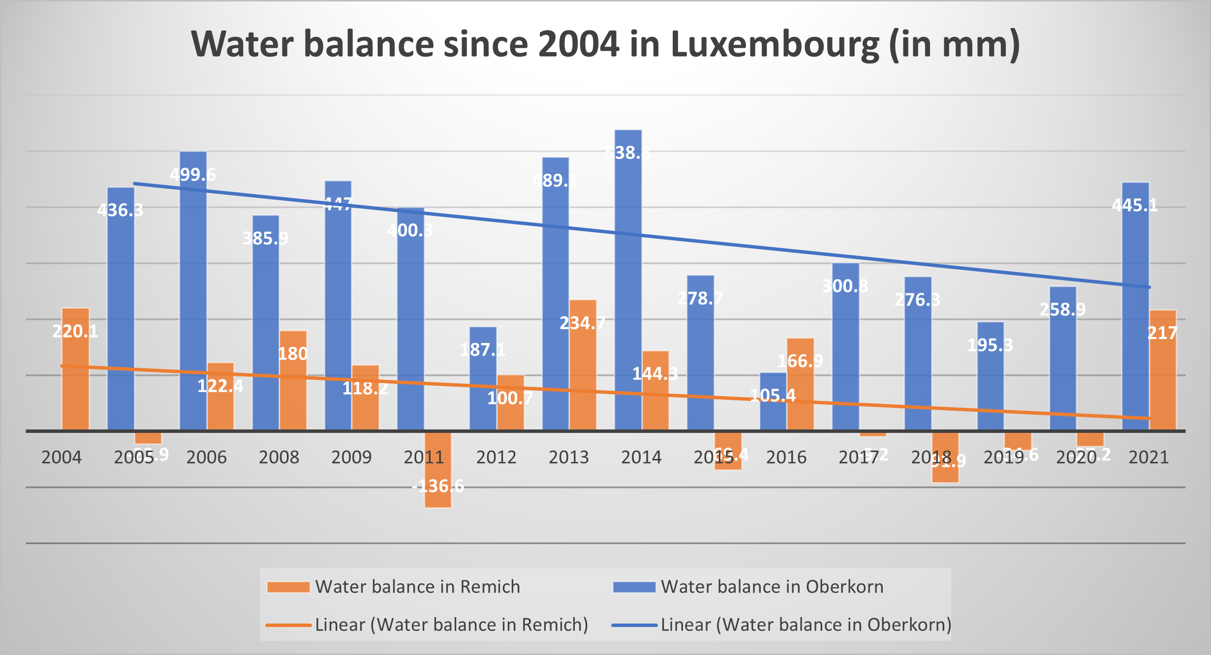
Figure 1: Water balance in the cities of Oberkorn and Remich (Luxembourg Agriculture Ministry, 2021).
Unlike in other countries, the natural hazard of shrinkage–swelling of clays, related to soil moisture, is not recognised by insurance companies. Moreover, our experience in Luxembourg and in the south of Belgium has demonstrated that this natural hazard is often unknown or misunderstood. For existing structures, actions dealing with it are limited and consist in intervening after damage has occurred, but it is possible to plan ahead for new construction projects.
Some countries, like France, have appropriate legislation and risk maps, which is not the case in other countries like Belgium or Luxembourg. The zones of foreseeable geological risks are not yet defined, and if the client does not surround himself with specialists aware of this risk, it will almost inevitably be forgotten, with the significant consequences that this could sometimes have. However, the phenomenon of the shrinkage–swelling of clays is one of the most widespread geological risks with consequences accentuated by the climate change, and which directly or indirectly affects a very large number of people. Indeed, as this phenomenon is linked to the humidity of clay soils, the occurrence and intensity of this phenomenon will probably continue to increase in the future. Therefore, it is absolutely necessary that awareness of the existence of this risk is raised and that it be taken into account in risk management from the design phase of the project.
In this paper, we will focus in more detail on Luxembourg, where a large part of the territory is made up of clay or clayey rocks. After a brief description of the geological situation and the characteristics of clay, we give an overview of the risks associated with its behaviour that are increasingly encountered because of climate change, discuss the classic methods of remediation and then explain an innovative method tested on a full-size site. We will thus show the results obtained in the context of remediation, keeping in mind that this technique can also be used to prevent risks and not only to remediate them.
All these considerations will allow us to draw several conclusions on the methods and means that could be implemented to promote awareness and thus contribute to reducing the risk. Indeed, too often we intervene only after damage is observed, when it would be simpler and less expensive to prevent the risk rather than to remedy it.
Geological background
Geology of Luxembourg
Luxembourg is divided in two geological regions, with different landscapes and bedrock. These two regions reflect the geological history of the Grand Duchy.
In the north, the Eisleck region is characterised by deep valleys incised in Devonian rocks (predating the Pragian and Emsian times) folded during the Hercynian orogeny. These formations represent the geological foundation of Luxembourg, and are mainly composed of schists, metasandstones, slates and quartzites (bluish-grey schists being the most common rock type). These rocks came from muddy and sandy sediments that have been consolidated over the ages. The formation thicknesses built up to several thousands of metres, and then were transformed during the Hercynian orogeny. Geological formations with schistosity are common in the Eisleck region, associated with second- or third-order folds (GSL, 2009).
From the Lower Triassic onwards (Buntsandstein), marine transgressions covered the eroded and folded Devonian basement and successively deposited sediments. The alteration products from the continent, more precisely from the Hercynian chain, were then transported by rivers and waves to the marine environment and the finer elements were carried to the seabed, where the sedimentation of clays and carbonates took place. When these elements were brought into lagoons (Middle Triassic), the detrital input then stopped, and the tropical climate of the Triassic period allowed strong evaporation of water and clay-evaporation sedimentation. This successive sedimentation led to the rocks of the southern Luxembourg that we know today, such as marls and sandstones.
The area remained marine again until the Middle Jurassic. Subsequently, further uplift processes due to the Alpine orogeny led to the erosion of these sediments in the north of the country, leaving the Devonian rocks exposed in the Eisleck region.
In the Gutland region in the south of Luxembourg, however, some of these Triassic and Jurassic sediments have remained. Gutland is thus characterised by a succession of hard and soft consolidated sedimentary rocks, which gradually plunge towards the southern end of the country. It is in this region that in the present time marls and clays are encountered.
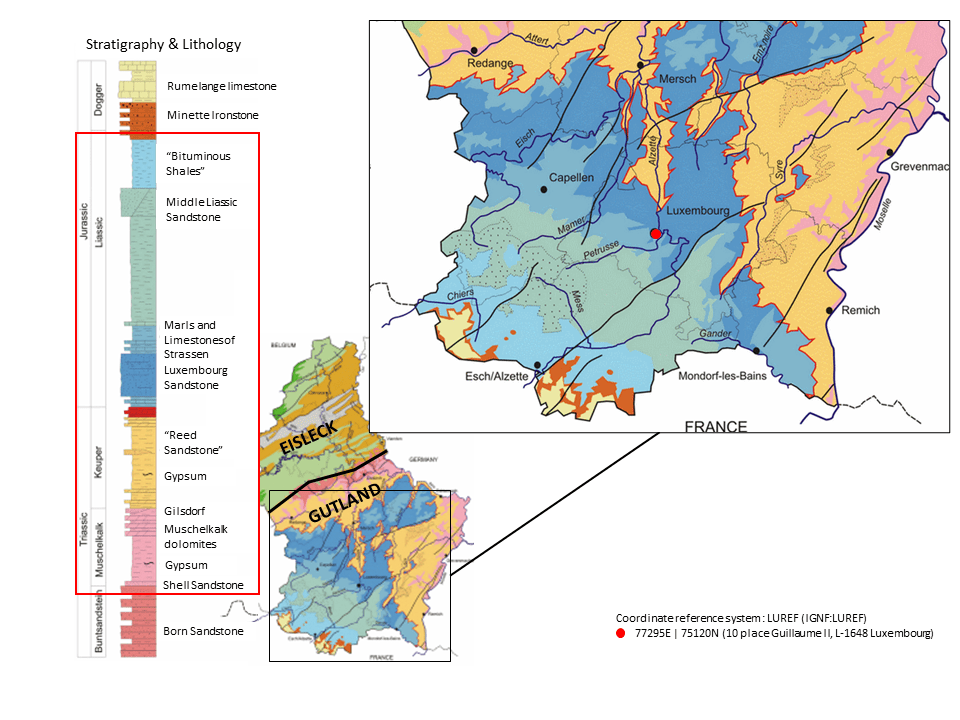
Figure 2: Geological map of the Grand Duchy of Luxembourg (GSL, 2009).
Definition of clay
Clay minerals are fine cohesive materials, composed of layers with water molecules between them. Clays are characterised by a grain size of less than 0.002 mm and are composed of minerals belonging to the phyllosilicate family (silicate minerals arranged in layers). Clay is a versatile mineral raw material: malleable and generally plastic when moist, it becomes cohesive, brittle, and crumbly after drying. Compound materials and clayey rocks, such as marl, also contain clay minerals and form generally soft rocks that retain the changing properties of clays in contact with water.
The sheets structuring the clays are in the nanometre range, and their size and structure depend on the minerals that compose them. There are two-layer structures, tetrahedral layers and octahedral layers; the alternation of these layers with cations forms the different minerals constituting the clay materials. Examples include kaolinite, glauconite, smectites, vermiculite and chlorite (Foucault & Raoult, 2005). The layered structure of clays allows them to trap water molecules longitudinally, and thus avoid their vertical circulation. Their layered structure gives the clays strong impermeability and allows them to play an important hydrogeological role.
The different minerals can be grouped mainly into three families called 1:1 or TO, 2:1 or TOT, and 2:1:1 or TOTO, where T stands for a tetrahedral layer and O for an octahedral layer. The following table gives examples of the different family structures.

Figure 3: Mineral structure of clays (Beaufort & Pagel, n.d.; Houti, n.d.; Lafuerza, 2017).
For example, the interfoliar space of smectite, like other clay minerals, depends on its hydration. Thus, the thickness of the smectite sheets is one of the most subject to variation.
Clay shrinkage–swelling phenomenon
Due to the mineral structure, clay materials are predisposed to the phenomenon of shrinkage and swelling. Clay materials exhibit different behaviour depending on their water content. Thus, a wet clay soil becomes sticky and plastic while the same soil in a dry state becomes brittle or even powdery. This change in texture is also accompanied by a variation in volume: wet clay soil tends to swell whereas it will tend to settle when it dries out (shrinkage phenomenon following the reduction in volume). The shrinkage cracks (“desiccation cracks”) which appear in a dry clay soil visually translate this variation in volume, which is simultaneously manifested by a vertical compaction of the soil. The intensity of the phenomenon is linked both to climatic conditions and to the minerals that compose the clays – smectite, vermiculite and montmorillonite are minerals that are very prone to the problem of shrinkage and swelling.
The swelling of clays occurs when water is absorbed, which increases the soil volume; physically this swelling results in a spreading of the clay layers. Shrinkage occurs when the clay dries out significantly, for example during a drought. Water evaporates from the clay, reducing its volume. The clay layers tighten, and the clays become hard and brittle. Shrinkage and swelling of clays is therefore a climate-dependent phenomenon.

Figure 4: Graphic shrinkage and swelling (DPPR-SDPRM, 2008).
The geological horizons likely to be impacted by the shrinkage–swelling phenomenon are cohesive formations with a high clay content such as clays or marls, these types of formation are located largely in the south of Luxembourg, in the Gutland region (Gruslin, S., 2019).
A wooded environment is also an aggravating factor, as tree roots tend to draw water from the ground. In Luxembourg and other countries with a temperate climate, the zone of influence of this phenomenon varies between 1.0 and 1.5 m deep under grass cover, but can expand to 2.5 or even 4.0 m in the presence of large trees nearby. In addition, it is considered that a tree creates around it a permanent moisture deficit over a radius varying between 1 and 1.5 times its height (DPPR-SDPRM, 2008).
Typically, the structures affected by this phenomenon are individual houses, often built with foundations on continuous footings embedded shallowly in the ground, devoid of break joints and surrounded by trees or hedges. Annexes added to a main building with shallow or less substantial foundations are also generally more affected.
This phenomenon of shrinkage–swelling of clays leads to differential settlement of parts of the construction that are more protected and parts that are more exposed to moisture variations, creating structural disorders that result in particular in cracks in the walls. These cracks exhibit a cyclic behavior: they tend to close in winter and to open in summer, with an increase in the volume of the clay soil during rainy periods, and a decrease in volume and settlement periods of drought. In addition to the fact that these shrinkage–swelling cycles ultimately weaken the structures, they also make any lasting repair work impossible. Therefore, the shrinkage–swelling issue should be dealt with before considering repair work. This work is generally expensive, which is why being able to anticipate risks and protect against them in advance would be beneficial for new construction.
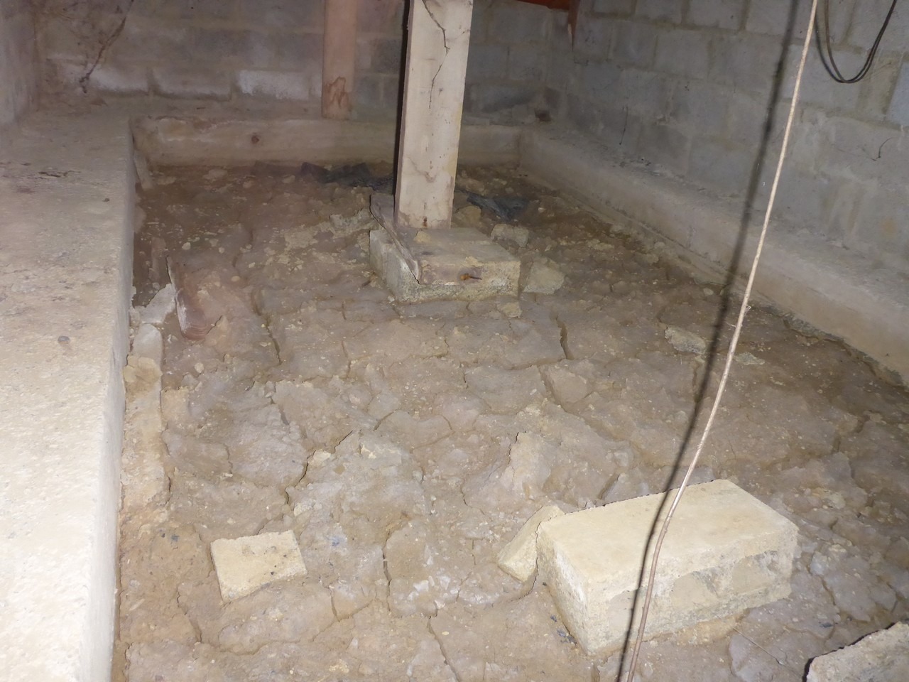
Figure 5: Desiccation crack inside a ventilated void of a house without a basement. The clays are totally dry on the inside, but their water content continues to vary on the outside, causing differential settlement and the appearance of cracks.
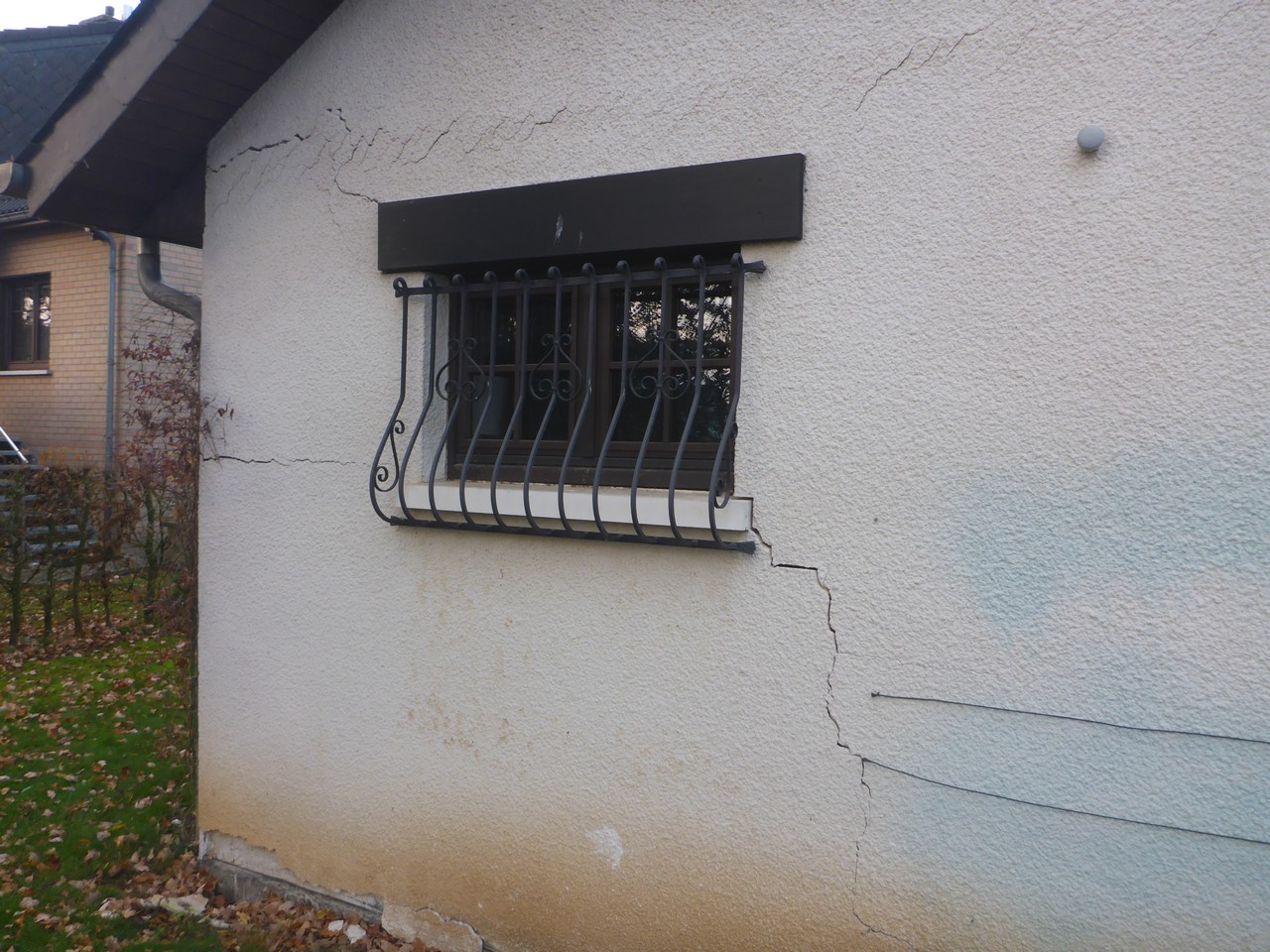
Figure 6: Cracks typical of a shrinkage–swelling phenomenon.
The shrinkage and swelling of clays are not dangerous geological hazards in themselves, but they can cause significant damage to buildings and infrastructure. In temperate zones such as Luxembourg, the phenomenon of clay shrinkage induced by droughts causes the most damage. In the context of global warming, drought phenomena will be more frequent and more severe, which is why it is necessary to quantify this hazard and to propose sustainable construction methods adapted to this environment (IFSTTAR 2017, Guide 1).
Geotechnical investigations
In addition to a glance at the geological map and a minimum knowledge of the geological and geotechnical conditions of the terrain, several relatively simple and quick tests are sufficient to determine whether the construction soils present a risk of shrinkage–swelling. These include the Atterberg limits, tests to determine the limits of shrinkage or even tests to determine the clay content, either the blue value test or – even better – mineralogical analyses to determine the proportion and type of clay minerals, some being more at risk than others of modifying the volume in the event of a change in the moisture content. Indeed, the blue test, although it is very quick and easy to use, is limited by the fact that methylene blue is in fact preferentially adsorbed by clays of the montmorillonite type (swelling clays) and organic matter. The other clays (illites and kaolinites) are not very sensitive to blue (IFSTTAR 2017, Guide 1) .In addition to these tests, the determination of the water content makes it possible to check whether there is a difference in natural water content between the protected zone and the exposed zone or even according to the seasons. Significant variations in water content are an additional indicator for quantifying the risk.These tests, which are easy to perform and relatively inexpensive, are often left out, either for cost reasons or for time constraints, with project owners generally wanting the project to move forward as quickly as possible. However, taking a little more time at the beginning of the project saves money and worries for the future. For larger projects, oedometer compressibility tests also provide a good idea of the deformation behaviour of foundation soils. The development of technical rules or binding specifications requiring a minimum number of geotechnical tests to be carried out would make it possible to identify the risk and to be able to protect against it.For structures affected by the phenomenon of shrinkage–swelling of clays, several classic remediation techniques exist. They are briefly summarised in the next section. However, these techniques have the big disadvantages of being expensive and sometimes causing relatively significant damage to the environment.
Typical mitigation techniques
To remedy the problem, it is possible to act either on the environment close to the construction, or to act on the foundations, or to act on the structure itself (IFSTTAR 2017, Guide 3).
First of all, it is necessary to control the variations of water infiltrating the soil and avoid having areas saturated with water and others not. However, this measure alone will not be sufficient. To limit variations in water content in the soil in the immediate vicinity of the foundations, the construction of a waterproof belt around the house can also be considered. This can be done by surrounding the building with a watertight system that is as wide as possible (minimum 1.5 m wide) protecting its immediate periphery from evaporation and keeping runoff water away that can infiltrate and modify subsoil water conditions. This system can be achieved by means of a concrete sidewalk or any other material with sufficient sealing or, in particular for aesthetic reasons, using a geomembrane buried under the topsoil to prevent changes in soil moisture (DPPR-SDPRM, 2008).
As far as possible, all shrubby vegetation should be kept away from the building at a distance of less than 1.5 times its height at maturity. In the event that felling is not possible, the creation of an anti-root screen can be considered. This consists in setting up a screen opposing the roots of a depth greater than the root system, with a minimum depth in all cases of 2 m, along the facades concerned. It should also be ensured that the consequences of a heat source located in the basement (boilers, etc.) are limited to prevent the ground from drying out around this heat source. If necessary, a thermal insulation device is to be provided (DPPR-SDPRM, 2008).
The most important and most suitable measure to avoid any problem in the future is to carry out an adaptation of the foundations in order to increase their anchoring depth and to extend them deeper than the slice of the ground concerned by the variations in the moisture content. For existing foundations, this can generally be done either by a classic underpinning of the foundations, by using micropiles, or if we want to correct the settlement instead to resolve the problem, by means of expanding resin injections. Micropiles and underpinnings can be carried out without major specific engins, but only make it possible to support the existing foundations without being able to counter the deformations which have already occurred. Injections have the advantage of being able, to a certain extent, to pressurise the existing foundations, which makes it possible to correct (at least in part) the deformations but requires a specialised company. The equipment used is also compact, which is better in narrow areas.
For economic and ecological reasons, the use of innovative more eco-friendly methods requiring little equipment would be preferred. For this reason, we tested on a full-scale site the reinjection during the dry period of water captured and stored during the wet period. This makes it possible to maintain a constant water content in the clays whatever the season and thus to avoid any movement. Another advantage of this method is that it can be a method of prevention and not only of remediation.
Case study
The studied case is a single-family building affected by differential settlement in the south of Luxembourg.
General context
The analysed building is a single-family house with a plan dimension of 12×11 m, with 3 floors and a basement. It is located in Esch-sur-Alzette, in rue Bessemer (Figure 7). The construction is from the 1920s and it is located at the end of a complex of terraced houses positioned along the street on the southwest side. Boulevard Prince Henry develops in a northwest-southeast direction at 15 m from the house. The semi-detached building is located on the northwest side. The land descends along the boulevard about 10 m at a distance from the site of 300 m in the southeast direction. The building is surrounded by a garden and plants and large trees are located near the cadastral limit at 5.0 m on the south side.
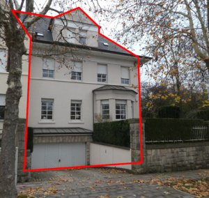
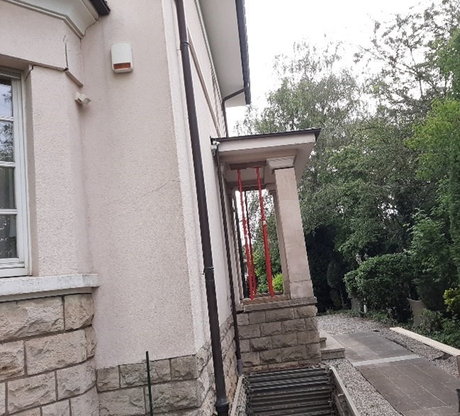
Figure 7: Photos of the building.
Geological and geotechnical context
The studied site is situated in layers form Toarcian (Upper Lias) period according to the geological map. These are composed of foliated, claystone-marlstone rocks with calcareous concretions. The covering clays resulting from the stones weathering have medium to high plasticity.
The site-specific stratigraphy was determined with a geotechnical survey (WPW Design Office, 2019). Three boreholes (BS1, BS2, BS3) and two light dynamic tests (DPL2, DPL3) were carried out (Figure 8). The light dynamic probing provides data on the clay consistency. Taking as the 0.0 level the building’s ground floor, the soil is a sandy and silty fill between -0.90 and -2.70 m. In BS2 and BS3, clays of different colors (ranging from red to gray with depth) of stiff to very stiff consistency are found up to -5.10 m. Between -5.10 m and -6.0 m the clays have a stiff consistency, then the number of blows increases until the weathered claystone is reached. As indicated in Figure 8, the number of blows is very different in BS2 and BS3. This is related to the different moisture content, with a more plastic behaviour in the BS3 borehole due to its higher moisture content. The clays between -2.60 m and -5.10 m were classified as firm. Up to the weathered claystone layer (-7.10 m), the clays are then classified as stiff. The weathered claystone was found under -6.80 m in borehole BS1.
The consistency difference can be found in the soil water content. The analysis revealed a very significant difference between the area exposed to the east at the depth between -3.90 and -6.90 m (BS3, water content of 26%) and the southwest areas (BS1, w=14.1 %, BS2 w=14.5 %). At this depth, clays in boreholes BS1 and BS2 are classified “TM” (clays with medium plasticity) and in BS3 “TA” (clays with high plasticity) following DIN 18196. The plasticity index of a clay sample from the borehole BS3 at a depth between -3.90 m and -6.80 m is 37.4 %.
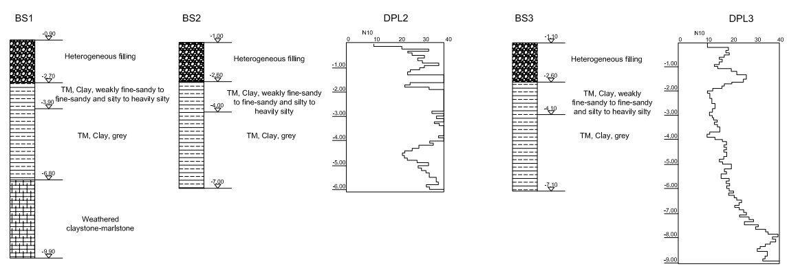
Figure 8: Site soil stratigraphy.
A mineralogical analysis with an X-ray diffractogram was done on the claystone (BS1, depth between ‑6.90 and 10.0 m) and on a clay sample (BS3, between -4.10 and -7.10 m, Figure 9). This showed the presence, among other things, of smectite-chlorite, together with more common clay minerals like illite and kaolinite (Figure 9).
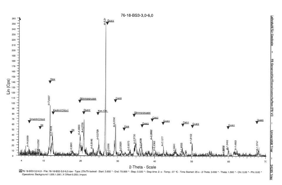
Figure 9: X-ray diffractogram on a clay sample taken from BS3 borehole (WPW Design Office, 2019).
Building structure and events history
The building structure is made of sandstone masonry. During the works, a weak presence of bonding mortar between the stones was discovered. The perimeter walls are 50 cm wide at their base and founded on an unreinforced concrete footing 80 cm wide at -3.50 m from the ground floor. The main structural element of the floors slabs and the roof are timber beams. The ground floor is made of steel beams with concrete filling between them. The building slabs are unidirectional in the west-east direction. The foundations of the entrance stairs were at -2.40 m from the ground floor. The reinforced concrete roof of the entrance is supported by the pillars and by the perimeter wall of the house through notches.
The current owner has occupied the building during the last 20 years. During this time, microcracks were noticed but their size did not affect the aesthetics and structure of the building. From March 2018, the magnitude and diffusion of the cracks suddenly increased, especially on the south-southwest side (Figure 10). The crack patterns show a rotation of the building in the south-west direction. Due to its relatively low weight and a higher foundation level, the entrance suffered major rotations, as visible in Figure 10.
Further investigations also revealed a malfunction of the downspouts. The pipes were blocked by debris, and they were perforated by shrubs roots located along the external wall of the house. As result, the pipes could not evacuate the rainwater properly. Afterwards, the pipes were repaired, and the shrubs removed.
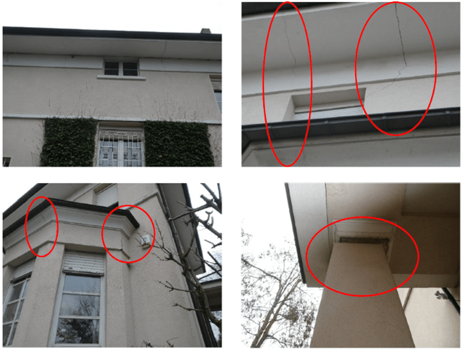
Figure 10: Cracks in the walls and rotation of the entrance pillar.
A monitoring system was set up in November 2019 using six crackmeters (PPW-POLYPLAN-WERKZEUGE GmbH, Rissobservator Artikel-Nr.: 1395, see Figure 11). The cracks were monitored over a six-month period. No further opening of cracks was noted. On the contrary, the cracks partially closed during the autumn-winter seasons due to the increase in moisture content.
The analysis of the behaviour of the cracks from the crackmeter measurements and the data collected in the geotechnical investigations led to the conclusion that the phenomenon was indeed linked to the shrinkage–swelling of the clays situated at the level of the foundations. The significant evolution and formation of cracks that took place during the year 2018 could be explained partially by the diminishing water balance that characterised the preceding period. Furthermore, the presence of dense vegetation and large trees along the house and the property limits accentuated the problem. Other factors could have been the south-west exposition of the damaged part of the house, which was more subject to the drying process and the downspout malfunction.
The north-east side suffered minor damages overall. The presence of artificial irrigation for the garden and the different exposition positively influenced the behaviour of the soil.
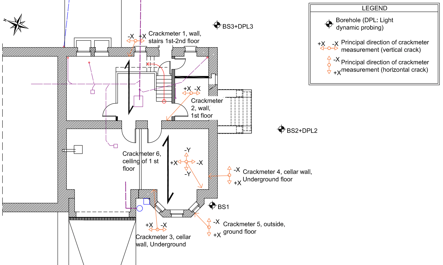
Figure 11: Plan view of the basement, direction of slab support, crackmeters and borehole position and crackmeter No. 5.
Stabilisation works
The stabilisation works started in June 2020. The objective of the intervention was to protect the soil under the foundations from important changes in the moisture content from the action of the nearby vegetation and drought periods. In order to avoid costly interventions such as a foundation on micropiles or underpinning of the perimeter walls of the house, a less invasive solution was chosen in order to maintain the water content at stable values.
The main measure was the installation of a DN100PVC perforated pipe along the west and south sides at approximately 4.50 m away from the house foundations. The installation depth was set at -2.70 m, on top of the clay layer. The tube was coated with gravel and a non-woven geotextile. Two inspections wells were also installed along the pipe for maintenance purposes. The system is connected on the north-west side of the sewage system to avoid excessive water flow in the soil. In order to provide a renewable water supply, a new rainwater tank collector was installed and connected to the renewed rainwater network. The water flow is controlled by a manual valve installed on the pipe in the tank with an overflow pipe connected to the sewage system installed in the tank to avoid flooding.
In addition to the main stabilisation intervention, secondary measures were carried out. The basement was protected by a waterproofing layer and a drainage layer was installed on the basement wall to divert excess water into a new drainage pipe near the foundations.
The entrance was founded on a more superficial layer ( -2.40 m), was thus more sensitive to the shrinkage–swelling phenomenon, as more superficial soil is more affected by variations in the moisture content due to seasonal effects. Consequently, the entrance was demolished and rebuilt with a new foundation at the same level as the building. The project overview is highlighted in Figures 12 and 13. Some photos of the intervention are shown in Figure 14.
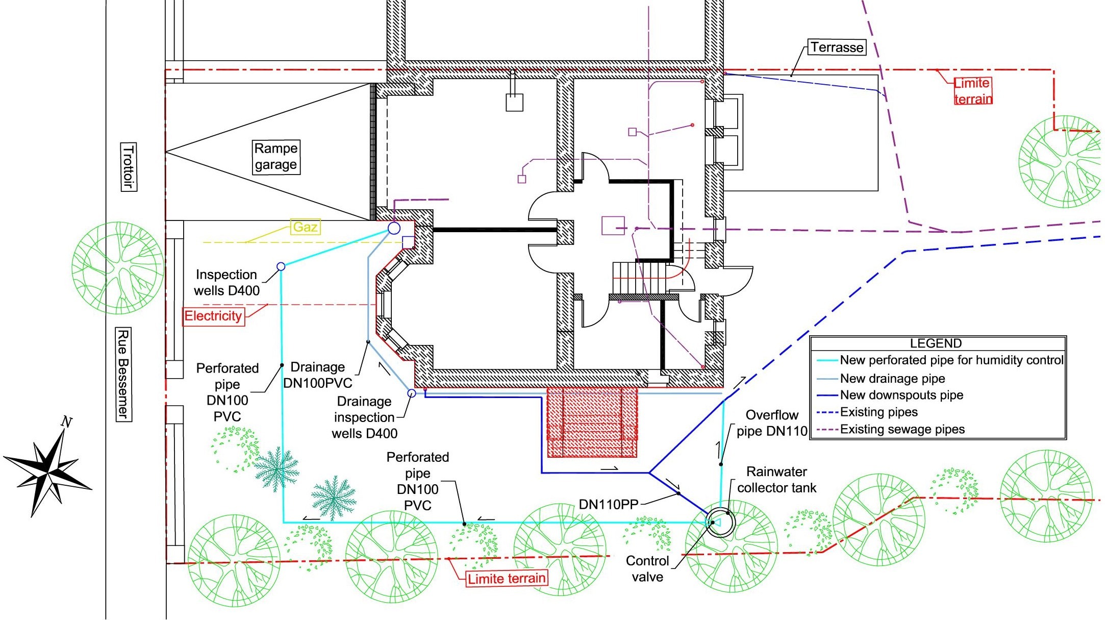
Figure 12: Project plan overview.
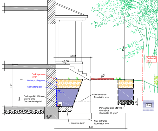
Figure 13: Project section view.
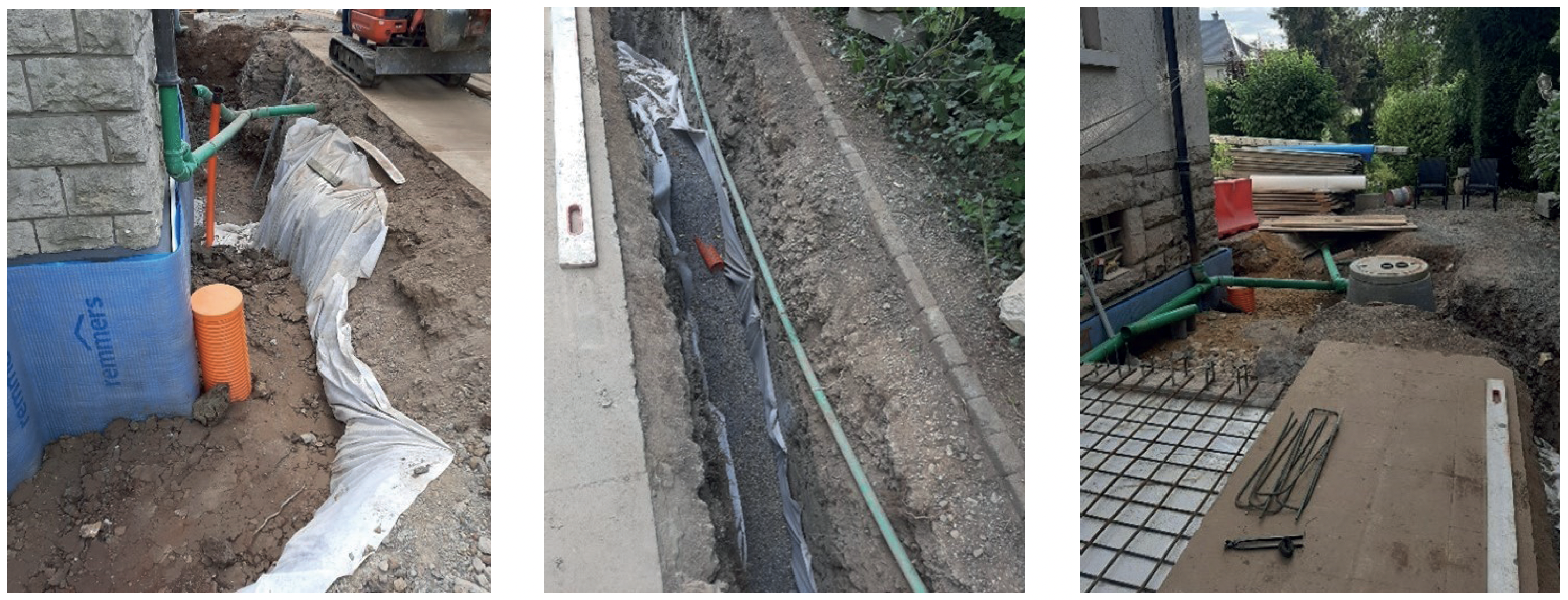
Figure 14: Stabilisation works: filling of the drainage trench, tank installation, perforated pipe for soil moisture management.
Post-intervention monitoring and results
The crackmeters were monitored during and after the stabilisation works. Figure 15 shows the evolution during the months following the intervention of the most critical crackmeter (No. 5), located at the south-west corner of the building (the most damaged part).
The analysis of the data shows the cracks started closing right after the crackmeter installation (November 2019). This is probably due to a seasonal effect. The perforated pipe for soil moisture control was operational from the end of July 2020. Figures 15-17 show that between autumn 2020 and February 2022 the crack size has been generally decreasing. Crackmeter No. 1 is less impacted due to its location at the north-east side of the construction, which was less damaged.
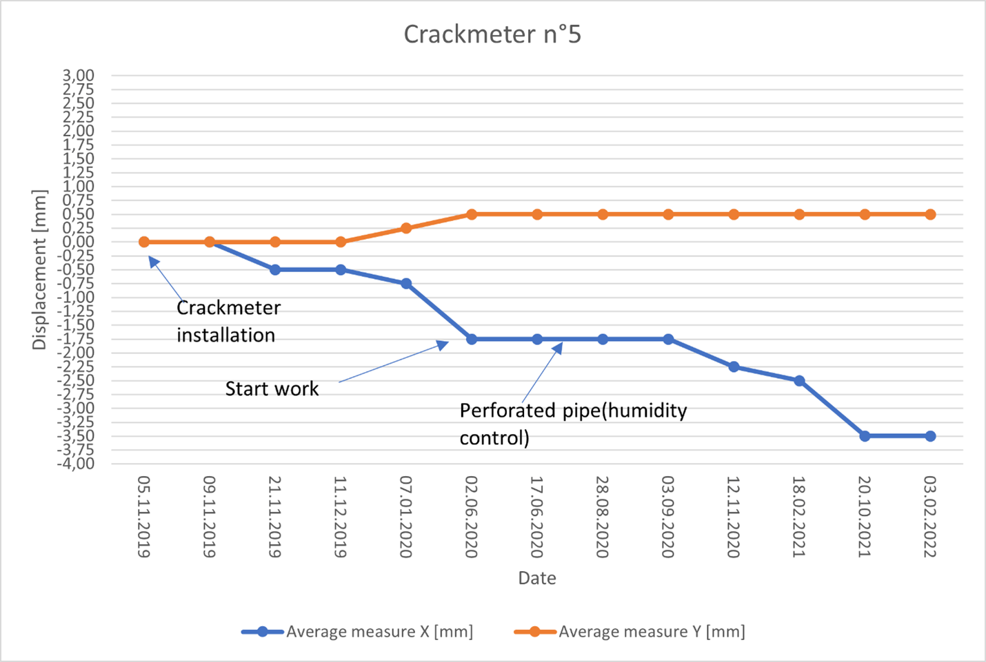
Figure 15: Measurements from crackmeter No. 5 (Nov. 2019 to Feb. 2022).
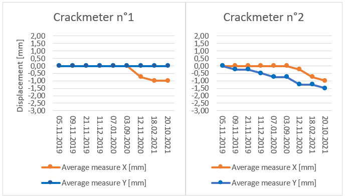
Figure 16: Measurements from crackmeters No. 1 and 2 (Nov. 2019 to Feb. 2022).
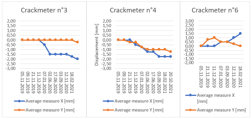
Figure 17: Measurements from crackmeters No. 3, 4, and 6 (Nov. 2019 to Feb. 2022).
Conclusion: the necessity for better management and changing the perception of risk
Clays concern a large part of the territory in places such as Luxembourg and the phenomenon of the shrinkage-swelling of clays due to variations of soil moisture, which could be further accentuated by climate change, impacts many people and will only increase in the future. The development of technical rules or binding specifications requiring a minimum number of geotechnical tests to be carried out would make it possible to identify this risk and be able to protect against it. The development of risk maps, which already exist in other countries, would have the advantage of targeting areas at risk and providing easily accessible and interpretable data, even to non-specialists.
Innovative and more environmentally friendly methods should be developed and promoted from the start of construction projects, in addition with the correct management of rainwater. All of this would allow better management account of the risk by all stakeholders, as well as the limitation of related costs. The maintenance of moisture in the soil near the foundation could be used in the future to stabilise or prevent possible damage to structure. The relative low cost compared to classical solutions makes this option very attractive. Furthermore, the excess water stored in rainwater tanks could be used for other purposes, like plant irrigation and creating value for the building. The system could be improved by automation, with soil moisture content sensors installed in the boreholes or piezometers of the geotechnical survey. The data could be collected in a data logger. Automatic post-processing of the data could warn the user to open or close the water valve. In some systems, such as condominiums, it could be useful to have a smart system with an electromechanical valve in order to make the process completely automatic.
References
Beaufort, D. & Pagel, M. n.d. Structure et propriétés des argiles (Structure and properties of clays), France. Encyclopédie Universalis (online). Accessed 02/02/2022. https://www.universalis.fr/encyclopedie/argiles/1-structure-et-proprietes-des-argiles/#DE131166
Foucault, A. & Raoult, J-F., 2005. Dictionnaire de géologie (Geology Dictionary). 6th edition. DUNOD. Paris.
GSL. 2009. Overview of the Geology of Luxembourg [online], Geological Survey of Luxembourg, Luxembourg. Accessed 27/01/2022]
https://geologie.lu/index.php/geologie-du-luxembourg/apercu-geologique/10-overview-of-the-geology-of-luxembourg
Gruslin, S., 2019. Liaison Esch-Micheville: illustration d’un cas particulier de roche altérée et évolutive: les argilites marneuses du Toarcien (Esch-Micheville connection: illustration of a special case of altered and evolving rock: the bituminous shales of Toarcian). Conference presentation, Construire sur des roches altérées/ évolutives, Journée d’étude de la Société Belge de Géologie de l’Ingénieur et de Mécanique des Roches. 21 November (Building on altered/evolutionary rocks, Study Day of the Belgian Society for Engineering Geology and Rock Mechanics).
Houti F.B, undated. Chapitre 2, “Les minéraux et les roches” (chapter 2, Minerals and rocks, in online textbook). Faculty of Technology, Aboubekr Belkaid University, Algeria. Accessed 02/06/2022. https://ft.univ-tlemcen.dz/assets/uploads/pdf/departement/gc/houti/Chapitre-2-LES-MINERAUX-ET-LES-ROCHES-2.pdf
IFSTTAR, 2017. Techniques et Méthodes. Retrait et gonflement des argiles, Caractériser un site pour la construction (Techniques and Methods. Clay shrinkage and swelling, Characterising a site for construction), Guide 1. French Institute of Science and Technology for Transport, Development and Networks.
IFSTTAR, 2017. Techniques et Méthodes. Retrait et gonflement des argiles, Analyse et traitement des désordres créés par la sécheresse (Techniques and Methods. Shrinkage and swelling of clays, Analysis and treatment of disorders created by drought), Guide 3. French Institute of Science and Technology for Transport, Development and Networks.
Lafuerza, S., 2017. Cours de sédimentologie. Chapitre 2 : environnements détritiques (Sedimentology course. Chapter 2: Detrital environments). Université UPMC, Paris.
Luxembourg Agriculture Ministry. 2021. Agri météo, Watterstation Oberkkorn et Remich (Watterstation Oberkkorn and Remich). Ministère de l’Agriculture et de la Viticulture et du développement durable du Luxembourg.
DPPR-SDPRM, 2008. Le retrait-gonflement des argiles. Comment prévenir les désordres dans l’habitat individuel ? (Clay shrinkage and swelling. How to prevent disorders in individual housing?) Collection prévention risques naturels majeurs. Ministère de l’écologie, du développement et de l’aménagement durables : direction de la prévention des pollutions et des risques (DPPR-SDPRM). Paris.
WPW Design Office, 2019. GEOTECHNISCHER BERICHT Nr. (Geotechnical report) Nr. WGL 18.70529-01.
This article has been published in European Geologist Journal 53 – Climate change – Increasing resilience with geological knowledge
Read here the full issue:
