
European Geologist Journal 52
GEMAS: Geochemistry of European agricultural and grazing land soil
by Alecos Demetriades1, Clemens Reimann2, Manfred Birke3, Philippe Négrel4, Anna Ladenberger5, Timo Tarvainen6, Martiya Sadeghi5, The GEMAS Project Team7
1 Institute of Geology and Mineral Exploration, Athens, Hellenic Republic
2 Geological Survey of Norway, Trondheim, Norway
3 Bundesanstalt für Geowissenschaften und Rohstoffe, Hannover, Germany
4 BRGM, Orléans, France
5 Geological Survey of Sweden, Uppsala, Sweden
6 Geological Survey of Finland, Espoo, Finland
7 The GEMAS Project Team: S. Albanese, M. Andersson, R. Baritz, M.J. Batista, A. Bel-lan, D. Cicchella, B. De Vivo, W. De Vos, E. Dinelli, M. Ďuriš, A. Dusza-Dobek, M. Eklund, V. Ernstsen, P. Filzmoser, B. Flem, D.M.A. Flight, S. Forrester, M. Fuchs, U. Fügedi, A. Gilucis, M. Gosar, V. Gregorauskiene, W. De Groot, A. Gulan, J. Halamić, E. Haslinger, P. Hayoz, R. Hoffmann, J. Hoogewerff, H. Hrvatovic, S. Husnjak, L. Janik, G. Jordan, M. Kaminari, J. Kirby, J. Kivisilla, V. Klos, F. Krone, P. Kwećko, L. Kuti, A. Lima, J. Locutura, D. P. Lucivjansky, A. Mann, D. Mackovych, J., Matschullat, M. McLaughlin, B.I. Malyuk, R. Maquil, R.G. Meuli, G. Mol, P. O’Connor, R. K. Oorts, R.T. Ottesen, A. Pasieczna, W. Petersell, S. Pfleiderer, M. Poňavič, S. Pramuka, C. Prazeres, U. Rauch, S. Radusinović, I. Salpeteur, R. Scanlon, A. Schedl, A.J. Scheib, I. Schoeters, P. Šefčik, E Sellersjö, F. Skopljak, I. Slaninka, A. Šorša, R. Srvkota, T. Stafilov, V. Trendavilov, P. Valera, V. Verougstraete, D. Vidojević, A. Zissimos and Z. Zomeni.
Contact: alecos.demetriades@gmail.com
Abstract
The project Geochemical Mapping of Agricultural and grazing land Soil (GEMAS) was carried out in 33 European countries (5.6 million km2) with an average sampling density of 1 site per 2500 km2. The main objective was to assess the chemical quality of productive soils. All collected soil samples were prepared in the same laboratory, and subsequently analysed for the same suite of elements and physicochemical parameters in the same laboratory following a strict quality control procedure. Data interpretation revealed that few soil samples reach element concentrations where toxicity may become of concern. However, more than 10% of samples contain such low element concentrations that deficiency for optimum plant growth and animal health may be a much larger issue warranting attention.
Cite as: Demetriades, Alecos, Reimann, Clemens, Birke, Manfred, Négrel, Philippe, Ladenberger, Anna, Tarvainen, Timo, & Sadeghi, Martiya. (2021). GEMAS: Geochemistry of European agricultural and grazing land soil. European Geologist, 52. https://doi.org/10.5281/zenodo.5770107

This work is licensed under a Creative Commons Attribution 4.0 International License.
Introduction
With an ever growing world population efficient and superior quality food production is becoming a major challenge (FAO, 2019). Well-organised and safe agriculture and animal husbandry depend substantially on healthy soil. Plants and animals require sufficient amounts of major and minor nutrients and low concentrations (or availability) of potentially toxic elements in soil.
The project Geochemical Mapping of Agricultural and grazing land Soil (GEMAS) was carried out by the Geochemistry Expert Group of EuroGeoSurveys in cooperation with Eurometaux (Association Européenne des Métaux), and other European and international institutions (Reimann et al., 2014a, 2014b). It documents, for the first time, the concentration of almost 60 chemical elements, analysed by three different methods (total, aqua regia and cold leach concentrations) and physicochemical parameters determining nutrient availability and binding in agricultural and grazing land soil samples at the scale of the European continent (33 countries and 5.6 million km2 were covered). In total, 2108 samples were collected from regularly ploughed fields (Fig. 1a), and 2024 samples from land under permanent grass cover (Fig. 1b). The agricultural soil samples were collected from the Ap horizon, the layer that has been disturbed by human activity such as mixing of the upper soil by ploughing in agricultural landscapes. In this case, the ‘p’ refers to the ‘ploughing depth’, which is on average down to a depth of 20 cm. The grazing land soil samples were collected from land under permanent grass cover or land that has not been disturbed for a period of at least ten years. As the interest is in the grass on which the animals graze, the upper 10 cm of soil was sampled as grass roots are usually concentrated in this section.
The samples were collected according to the specifications of the European Union’s REACH regulation (Registration, Evaluation, Authorisation and Restriction of Chemicals; EC, 2006; EGS-GWG, 2008; Reimann, 2014). The REACH regulation aims to improve the protection of human health and the environment from potential risks posed by chemicals.
The GEMAS project data sets were made available to the general public in 2014 with the release of a two-volume atlas with the title “Chemistry of Europe’s Agricultural Soils” (Reimann et al., 2014a, 2014b).
As part of GEMAS valorisation, a series of peer-reviewed publications, where detailed interpretation of the continental-scale distribution of single elements or related groups of elements, have been published, e.g., Reimann et al. (2012a − Pb); Ottesen et al. (2013 − Hg); Tarvainen et al. (2013, 2014 − As); Scheib et al. (2012 − Nb); Sadeghi et al. (2013 − Ce, La, Y); Baritz et al. (2014 – C); Birke et al. (2014a, 2016, 2017 – Cd); Poňavič and Scheib (2014 – Se); Cichella et al. (2014 – U, Th, K); Ladenberger et al. (2015 − In); Albanese et al. (2015 − Cr, Ni, Co, Cu); Négrel et al. (2016 – Ge; 2018a – U, Th; 2018b − Rb, Ga, Cs; 2019 − Sb, W, Li; 2021 − Mg); Fabian et al. (2014 – pH; 2017 – Pb); Jordan et al. (2018 – Ni); Matschullat et al. (2018 – C, N, S); Hoogewerff et al. (2019 – 87Sr/86Sr), and Xu et al. (2019 – TOC, pH).
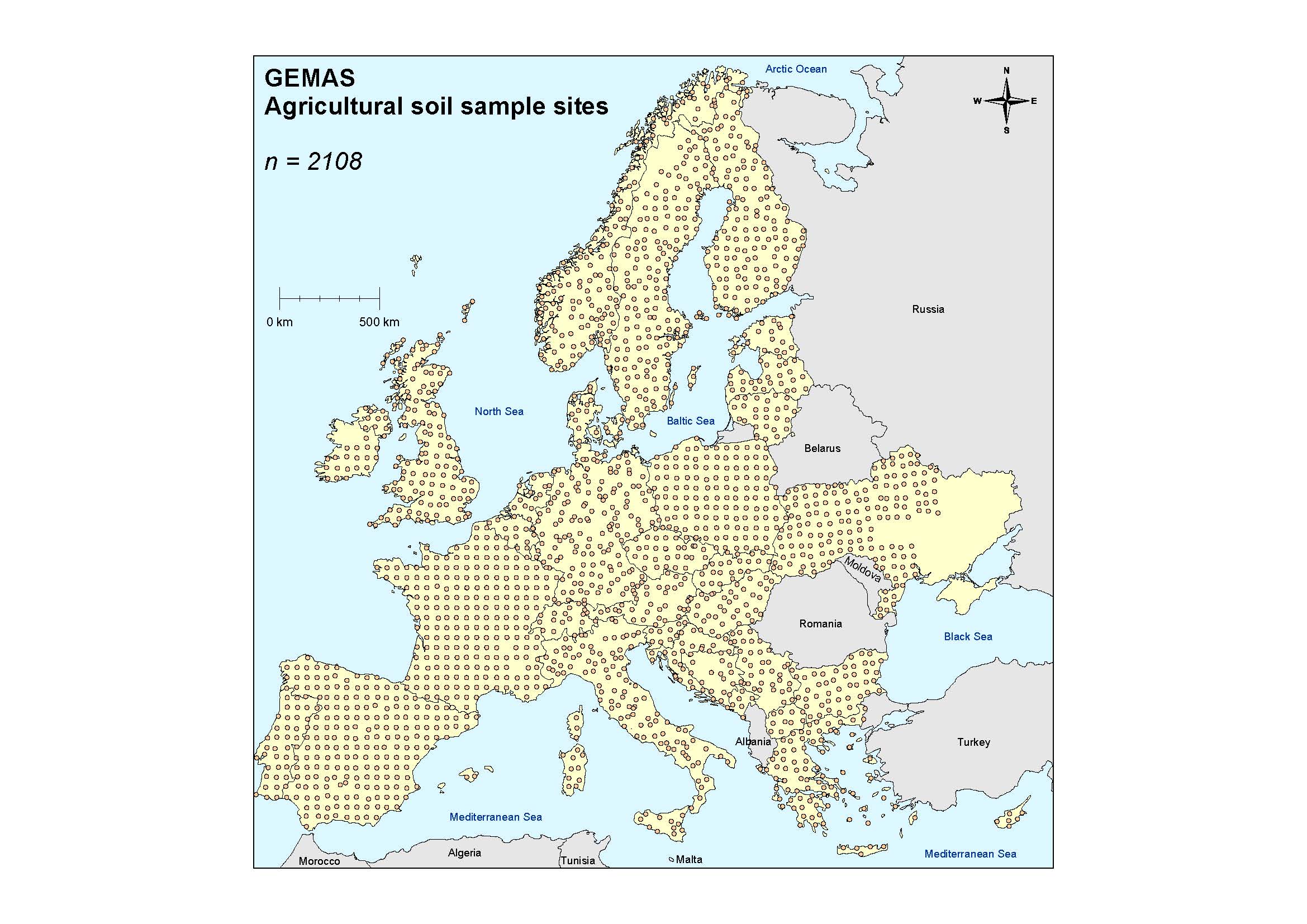

Figure 1: Maps showing the distribution of (a) agricultural soil samples, and (b) grazing land soil samples. A few countries collected samples at the grid nodes of a regular grid of 50 × 50 km, and other countries used a random sampling scheme within the same grid dimensions, and both retained the nominal sampling density of 1 site/2500 km2.
Harmonised high quality soil geochemical data sets
The GEMAS project has produced high quality exposure data for chemical elements
across Europe that are harmonised with respect to: (1) land-use (agricultural soil, 0–20 cm and grazing land soil, 0–10 cm) – Figures 1 & 2; (2) spatial scale (homogeneous sampling density of 1 site/2500 km2, i.e., a grid of 50 × 50 km was used (EGS-GWG, 2008; Reimann, 2014); (3) sample preparation (<2 mm grain size), and sample splitting in the same laboratory (Mackovych and Lucivjansky, 2014), and (4) analytical methodology: all samples for the same suite of elements and physicochemical parameters were analysed in the same laboratory, namely (a) aqua regia extraction (ICP-MS 53 elements), (b) total (X-ray fluorescence, 41 elements), (c) mobile metal ion cold leach (MMI®, 55 elements), (d) lead isotope ratios, (e) pH (0.01M CaCl2), (f) total organic carbon, total carbon, total sulphur, effective cation exchange capacity (eCEC at pH of the soil, silver thiourea method), (g) mid-infrared (MIR) spectra, (h) texture (sand, silt, clay) and (i) partitioning coefficients (kd-values) for selected elements (Reimann et al., 2009, 2011, 2012b; Birke et al., 2014b). Quality control of all analytical results is documented in three publicly available reports (Reimann et al., 2009, 2011, 2012b).
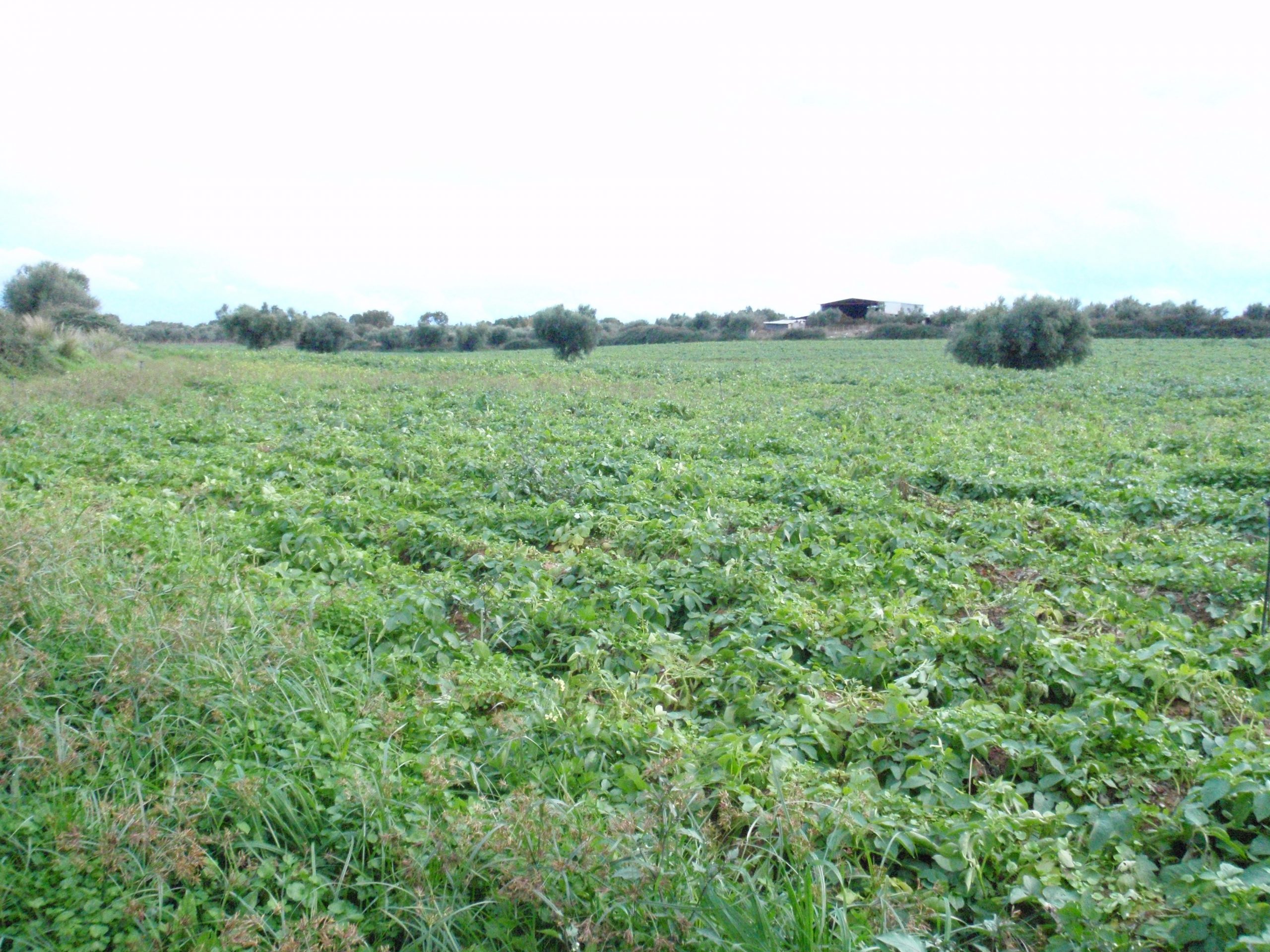
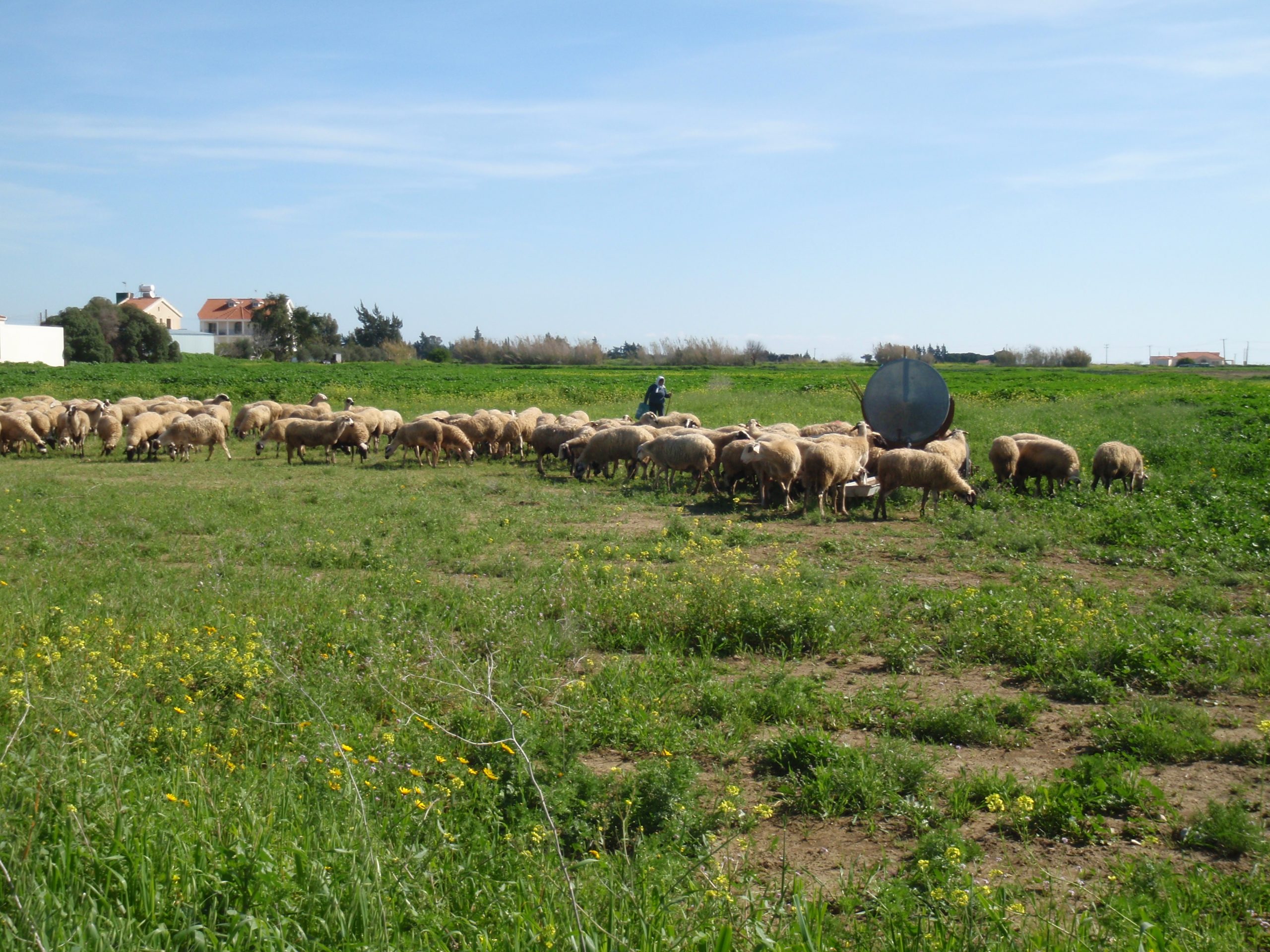
Figure 2: Photographs of (a) agricultural soil with cabbages, Hellas, and (b) grazing land soil with sheep grazing, Larnaca district, Cyprus.
Large North-South differences
A major spatial difference in geochemical patterns is observed in the concentration of many chemical elements between the soil of northern and southern Europe. The young soil from northern Europe has 2 to 3 times lower element concentrations than the more mature, weathered and older soil in southern Europe. The arsenic (As) maps of agricultural and grazing land soil show this feature clearly with higher concentrations in southern and western Europe compared to northern Europe (Fig. 3). When comparing the geochemical maps with the geological map (Fig. 4a), the boundary between northern and southern Europe coincides remarkably well with the maximum extent of the last glaciation (Fig. 4b).

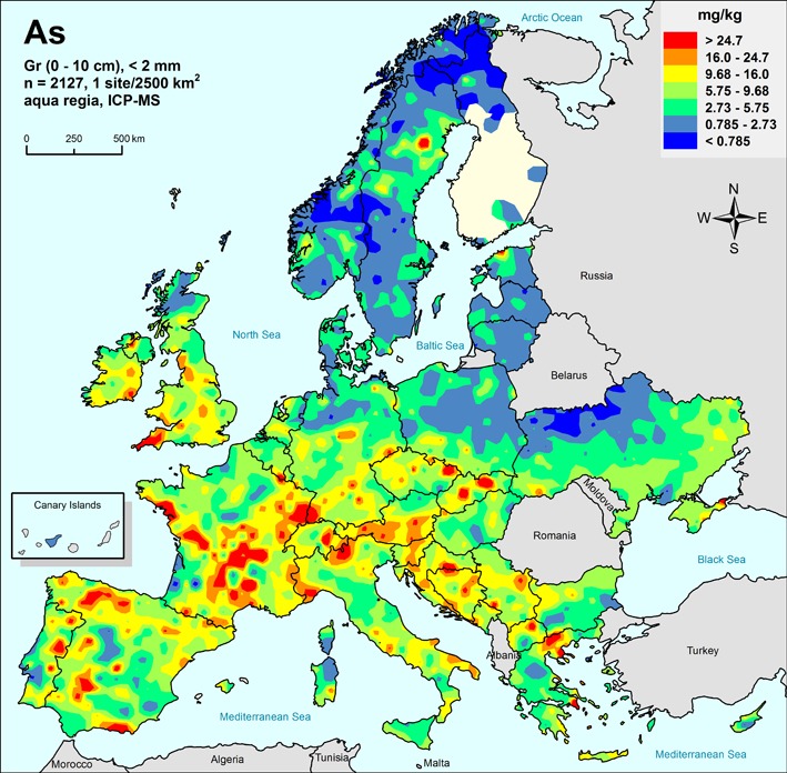
Figure 3: Geochemical maps showing the distribution of arsenic (As) in (a) agricultural soil and (b) grazing land soil (Reimann et al., 2014c, Fig. 11.9.5, p.154). Note the distinct north-south differences, and the comparable results of the two different sample types.
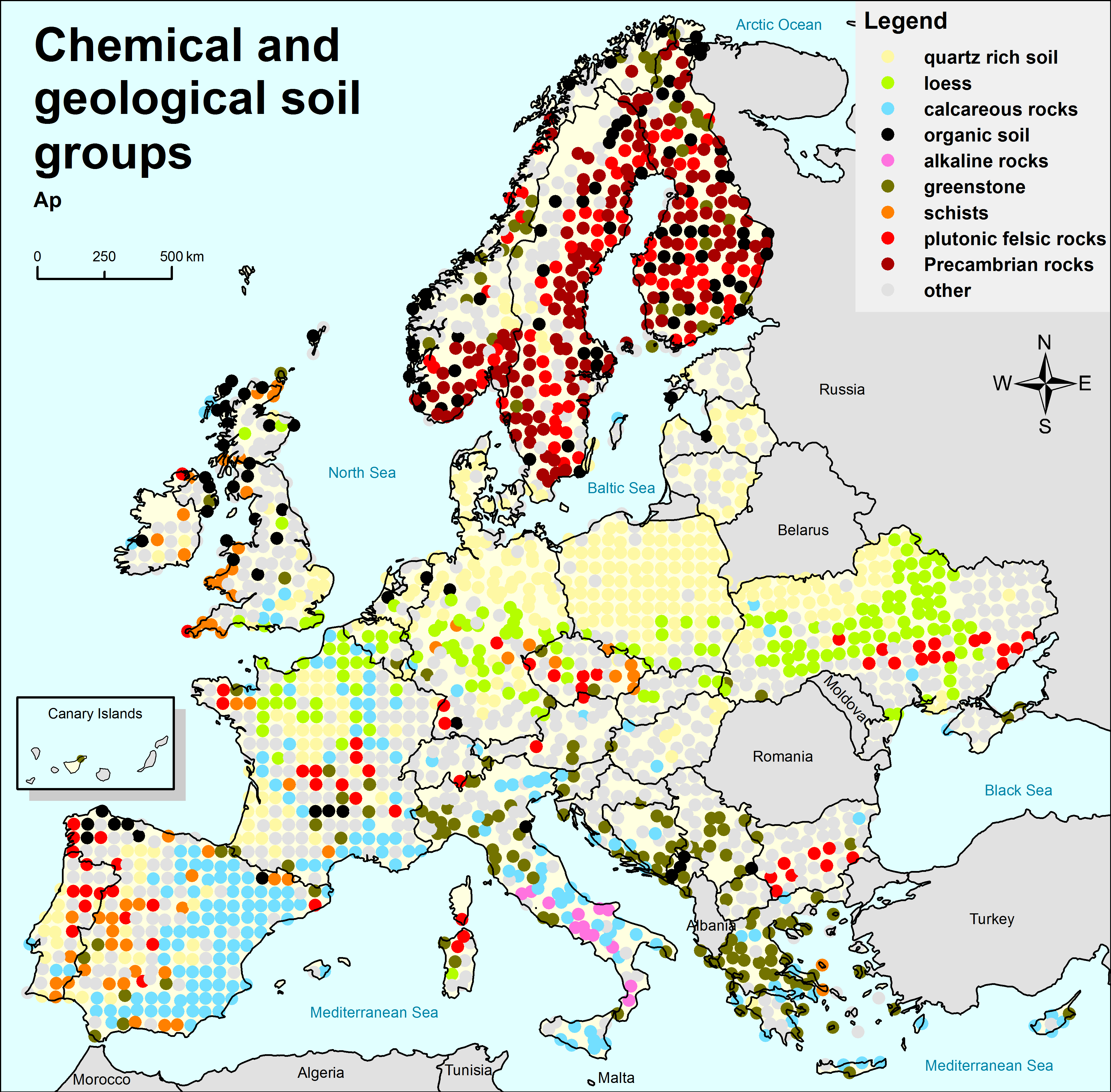

Figure 4: Maps showing (a) parent materials chemical and geological soil groups of agricultural soil (Ap) samples (Birke et al., 2014c, Fig. 10.8, p.98), and (b) distribution of aeolian deposits with maximum extent of the last glaciations (Weichset 18-22 ka) from Scheib (2014, Fig. 9.1, p.162); loess data for continental Europe redrawn from Haase et al. (2007); loess of southern Britain are based on Antoine et al. (2003), and generalised extent of coversand is based on Kasse (1997), Zeeberg (1998), and Bertran et al. (2009).
Two different sample materials deliver comparable results
Two different sample materials, ploughed soil (0–20 cm) and grazing land soil (0–10 cm), taken at separate locations at a density of 1 site/2500 km2 all over Europe and with different depth sampling ranges, deliver very comparable distribution maps of chemical elements. The two maps of arsenic (As) distribution in agricultural and grazing land soil samples illustrate this feature very well (Fig. 3). It is apparent that low sample density mapping results in robust maps.
Substantial differences among country soil median values
Major differences are observed in elemental median values of agricultural and grazing land soil samples in the different European countries (Fig. 5). On average, there is a sixfold difference in the median concentration of the elements among the 33 countries sampled. Several elements show even substantially larger differences, up to a factor of more than 100 times. For nickel (Ni) (Figure 5), the lowest median value is observed in Poland (about 5 mg/kg), and the highest in Montenegro (almost 100 mg/kg).
Given these large natural differences, it is exceedingly difficult to define a single European background value for each element. This regionality is a crucial factor to consider in soil legislation, which sets out to determine threshold or action levels for chemical elements for all European Union countries.
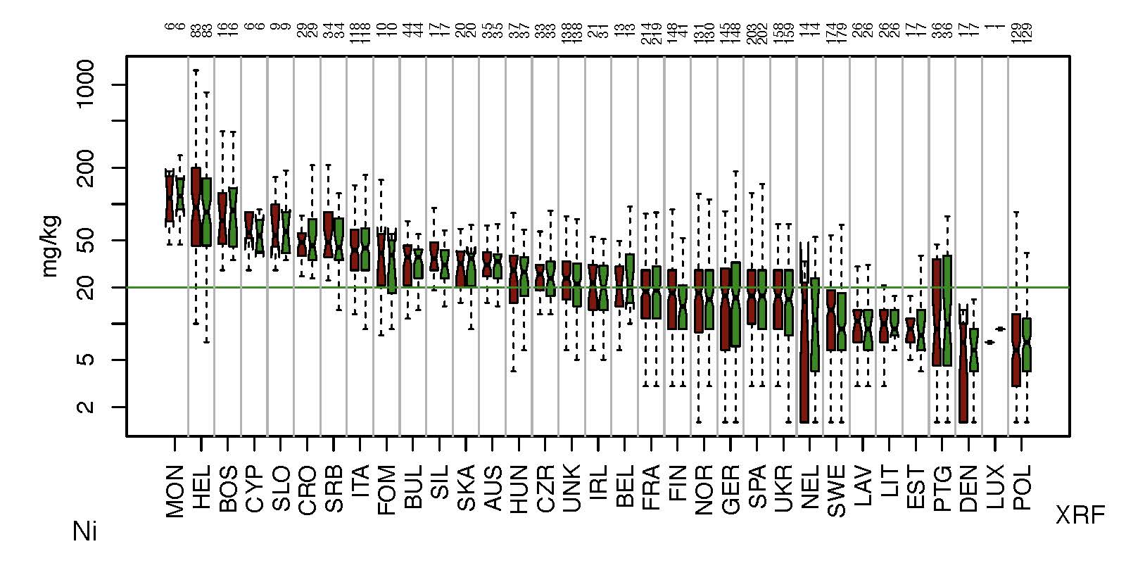
Figure 5: Boxplot comparison of nickel (Ni) concentrations in agricultural (Ap – dark red) and grazing land (Gr – green) soil samples of Europe (from Reimann et al., 2014c, Fig. 11.39.4, p.327). To focus on the main body of data the boxplots are shown without outliers (i.e., values 1.5 times the interquartile range above the upper quartile and below the lower quartile). The boxplots are ordered according to decreasing median values. The number of samples collected in each country is indicated on the top of the diagram. Countries: AUS: Austria; BEL: Belgium; BOS: Bosnia and Herzegovina; BUL: Bulgaria; CRO: Croatia; CYP: Cyprus; CZR: Czechia; DEN: Denmark; EST: Estonia; FIN: Finland; FOM: North Macedonia; FRA: France; GER: Germany; HEL: Hellas (Greece); HUN: Hungary; IRL: Republic of Ireland; ITA: Italy; LAV: Latvia; LIT: Lithuania; LUX: Luxembourg; MON: Montenegro; NEL: The Netherlands; NOR: Norway; POL: Poland; PTG: Portugal; SIL: Switzerland; SKA: Slovakia; SLO: Slovenia; SPA: Spain; SRB: Serbia; SWE: Sweden; UKR: Ukraine; UNK: United Kingdom. The green line shows the median concentration at 20 mg/kg Ni for both Ap and Gr soil samples.
The impact of geology
Geology, or better the distribution of parent materials for soil formation, plays a key role in determining the patterns observed on the geochemical maps. Most geochemical maps for metals are dominated by anomalies related to single ore deposits or metallogenic provinces. Soil developed on the sediments of the last glaciation, on chalk and limestone, felsic and mafic igneous rocks (e.g., granite, alkaline igneous intrusions) or black shale, all have their own characteristic geochemical signature that can be detected on the maps. For example, the high Si concentrations in soil are observed over the thick quartz-rich sediments of the last glaciation in north-central Europe, derived from the erosion of Fennoscandian silica-rich bedrock (Fig. 6a). Areas underlain by calcareous rocks (chalk, limestone, marble) are indicated by high calcium (Ca) concentrations on the map (Fig. 6b), e.g., southern England, Paris basin, Cevennes and Provence-Alpes-Côte d’Azur in southern France, eastern Spain and the Apennines in Italy. Even the principal geological difference between Fennoscandia and the rest of Europe is reflected on the Ca map, i.e., the minor occurrence of carbonate rocks in the Archaean and Precambrian rocks in Fennoscandia and their widespread occurrence in the Palaeozoic-Mesozoic-Tertiary formations of the rest of Europe. On a more local scale, the area with low Ca concentrations at the Norwegian/Swedish border (Fig. 6b) marks a sandstone unit, which is indicated by elevated Si concentrations (Fig. 6a).
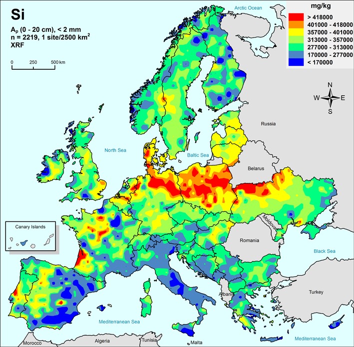

Figure 6: Total concentrations of (a) silicon (Si) and (b) calcium (Ca) in agricultural (Ap) soil samples, determined by X-ray fluorescence (XRF). From Reimann et al., 2014c, Figs. 11.51.5, p.399 & 11.16.5, p.200, respectively.
The impact of human activities
For a few elements, typically those associated with human activities (e.g., mercury (Hg), lead (Pb) but even silver (Ag) and gold (Au)), some (but far from all) European cities are noticeable by the elevated element concentrations in the agricultural soil samples taken in their vicinity. For example, the surrounding areas of London, Paris and Rotterdam are marked by high Hg values in agricultural soil (Fig. 7a), a feature shown on other geochemical distribution maps, e.g., Pb, Ag, Au. Kiev is also clearly discernible by a Hg anomaly, which is most likely due to the presence of a mercury processing facility right in the city. London, Paris and Amsterdam are indicated by Au anomalies (Fig. 7b). Otherwise, an anthropogenic impact is difficult to detect at the mapping scale of the GEMAS project (1 sample site/2500 km2). The location of most metal smelters or coal-fired power plants remains invisible on the continental-scale geochemical maps.
The Hg anomalies in the Rome/Naples agglomerations in Italy are presumably of natural origin and due to the occurrence of alkaline volcanic rocks (Fig. 7a). Large European Hg deposits like Almadén in the Spanish province of Ciudad Real, the Asturias mining district in NW Spain, and Monte Amiata in the southern Tuscany region of Italy are also marked by distinct Hg anomalies (Ottesen et al., 2013). Many of the Hg anomalies in Scandinavia, along the west coast of Scotland and Ireland are due to the occurrence of organic matter-rich soil and the natural enrichment of Hg in humus.
Generally, most of the high element values observed on the GEMAS geochemical maps are clearly related to natural metal occurrences or to specific rock types that are enriched in these elements. Overall, the human impact on the quality of agricultural and grazing land soils is remarkably low at the continental-scale of the GEMAS project (1 sample site/2500 km2).
In terms of the few existing national soil action levels for agricultural soil in Europe, an important observation is that in general very few soil samples deliver results that are above any known action level.
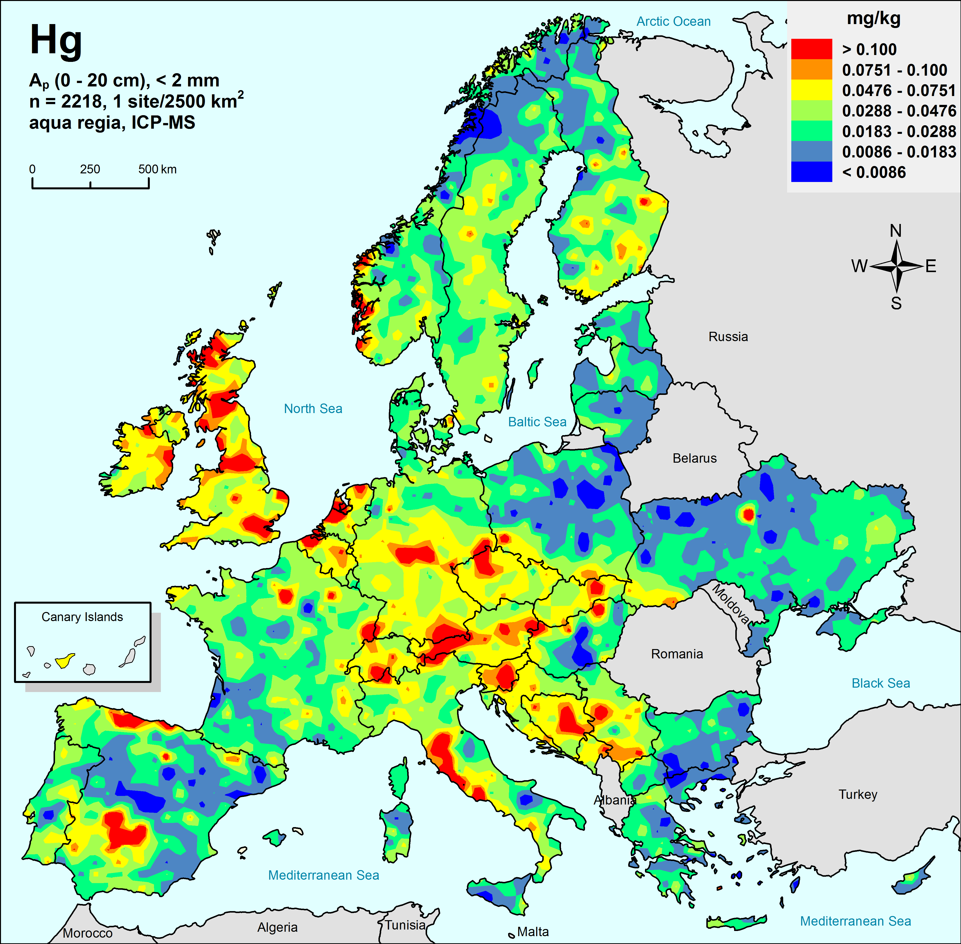
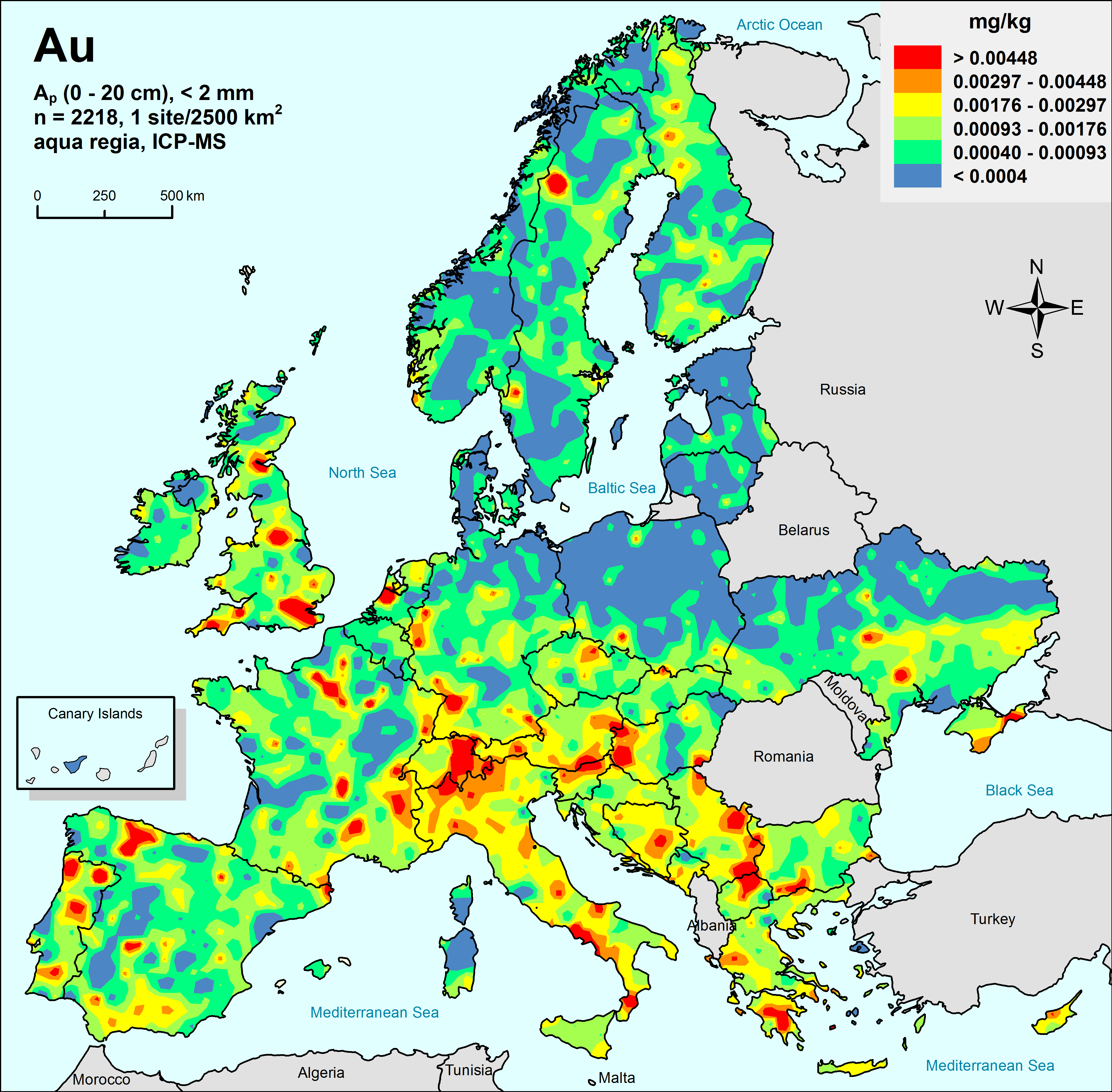
Figure 7: Geochemical maps showing the distribution of (a) mercury (Hg) and (b) gold (Au) in agricultural soil samples (Ap horizon) of Europe. From Reimann et al., 2014c, Figs. 11.29.5, p.269 & 11.10.5, p.161, respectively.
Risk assessment
How can toxicologically relevant element concentrations in soil samples be detected? The answer to this question is the existence of harmonised and validated measurements of element concentrations in agricultural and grazing land soil samples, in combination with results for parameters (such as pH, CEC, TOC) determining the availability of the elements in soil, allowing for the first time a realistic risk assessment of trace elements in soil at the European scale (Fig. 8). The generated data sets have been used by several European metal industries under the European REACH regulation to assess the risks of the metals they produce to organisms living in agricultural and grassland soils in Europe (Oorts & Schoeters, 2014; Oorts et al., 2016). In fact, an exceedingly small proportion of the GEMAS project soil samples exhibit a risk due to high metal concentrations.
Risk characterisation ratios (RCRs) are calculated as the ratio of measured aqua regia-extractable Cu concentration over the corresponding predicted no-effect concentration for risk characterisation (PNEC). The PNECs, or ecological soil standards, can be compared with prevailing exposure concentrations in soil to identify areas with potential risk (Oorts et al., 2016). For copper (Cu), most of the agricultural soil samples at risk were taken in vineyards (use of Cu-based pesticides) (Oorts & Schoeters, 2014).

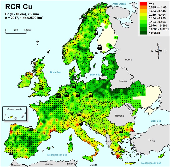
Figure 8: Distribution of risk characterisation ratios (RCR), calculated as the ratio of measured aqua regia extractable concentration of Cu with respect to the corresponding predicted no-effect concentration for risk characterisation (PNEC) for (a) agricultural soil, and (b) grazing land soil. Only a few isolated sites are predicted to be at risk for Cu (i.e., risk characterisation ratio, RCR >1). About 1.5% and 1.3% of sample sites for (a) agricultural and (b) grazing land soil, respectively, were predicted to be at risk. From Oorts & Schoeters, 2014, Fig. 12.7, p.198, with addition of large smelters.
Is diffuse contamination a serious threat to soil quality?
The European Commission has identified diffuse contamination as one of the eight threats to sustainable soil quality in Europe (EC, 2002). The GEMAS geochemical maps demonstrate that the impact of diffuse contamination, especially long-range transboundary air pollution, on the quality of European agricultural soil is vastly overestimated at present. Contamination from anthropogenic sources plays a key role at a much more local scale (e.g., see above the impact of cities like London and Paris on the Hg concentrations in soil), and sometimes at the regional scale but remains undiscernible at the continental scale. At the European scale, the GEMAS geochemical maps show that the occurrence of ore deposits, geology (certain rock types enriched in specific elements) and climate play the key role in determining the observed element spatial distribution patterns. Surprisingly, neither agriculture nor diffuse contamination have affected the (semi-) total chemical composition of European agricultural soil at the continental scale (Fabian et al., 2017; Reimann & Fabian, 2021). However, the weak cold extraction (MMI®) method showed potential effects of, for example, Cd concentrations from fertilisers in some agricultural areas of Europe (Reimann et al., 2014c; Mann et al., 2015). These observations indicate that diffuse contamination is a more complex issue than one might expect, and the superimposed effects of anthropogenic activities on soil should always be calibrated against the local natural geochemical background.
Health implications: element deficiency needs more attention
The interplay between element toxicity and deficiency has important consequences for health implications. Many trace elements play a vital role in the health of plants, animals and humans (Kabata-Pendias & Mukherjee, 2007; Alloway, 2013). For instance, molybdenosis is a disease affecting ruminants such as cattle and sheep but also wild grazing animals, mainly deer and moose. It is caused by grazing on land with increased molybdenum (Mo) concentrations in soil (Fig. 9a). The high intake of Mo results in a copper (Cu) deficiency, which leads to many severe health problems, including organ failure and death. The massive death incidents of moose in Sweden in the 1980s and 1990s were likely caused by liming to prevent acidification of forest soil, which resulted in Mo mobilisation, which in turn reduced Cu uptake in the diet of the moose (Broman et al., 2002).
Another example is selenosis, a poisoning of livestock caused by the ingestion of selenium (Se), which can be enriched in some plants by microorganisms or in soil due to specific climatic conditions. In Europe, excessive Se concentrations occurring along coastal areas of United Kingdom, NW Spain, NW France and Norway are due to the steady input via marine aerosols in combination with a strong affinity to bind to organic matter in soil (Fig. 9b). The highest Se enrichment in European agricultural soil occurs in Ireland. However, at the continental scale Se deficiency may be a larger problem than Se toxicity.
Copper (Cu) and zinc (Zn) are two metals that are usually of concern when they occur at high levels, whether their origin is natural or anthropogenic (Fig. 10). Both Cu and Zn are, however, important nutrients and at the European scale deficiency of these elements in soil may be a much larger concern warranting attention than their toxicity (e.g., Cu and Zn have high statutory action values, which are rarely observed in agricultural and grazing land soil – see Appendix A in Reimann et al., 2014d).
Overall, very few agricultural and grazing land soil samples reach alarming concentrations where toxicity may become of concern. However, more than 10% of the GEMAS soil samples contain such low concentrations that deficiency is an issue for optimum plant and animal health and productivity may be of much greater concern.


Figure 9: Geochemical maps showing the distribution of (a) molybdenum (Mo) and (b) selenium (Se) in agricultural soil samples. From Reimann et al., 2014c, Figs. 11.36.5, p.311 & 11.50.5, p.393, respectively.
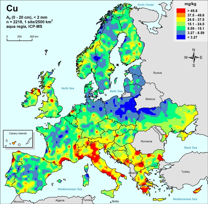
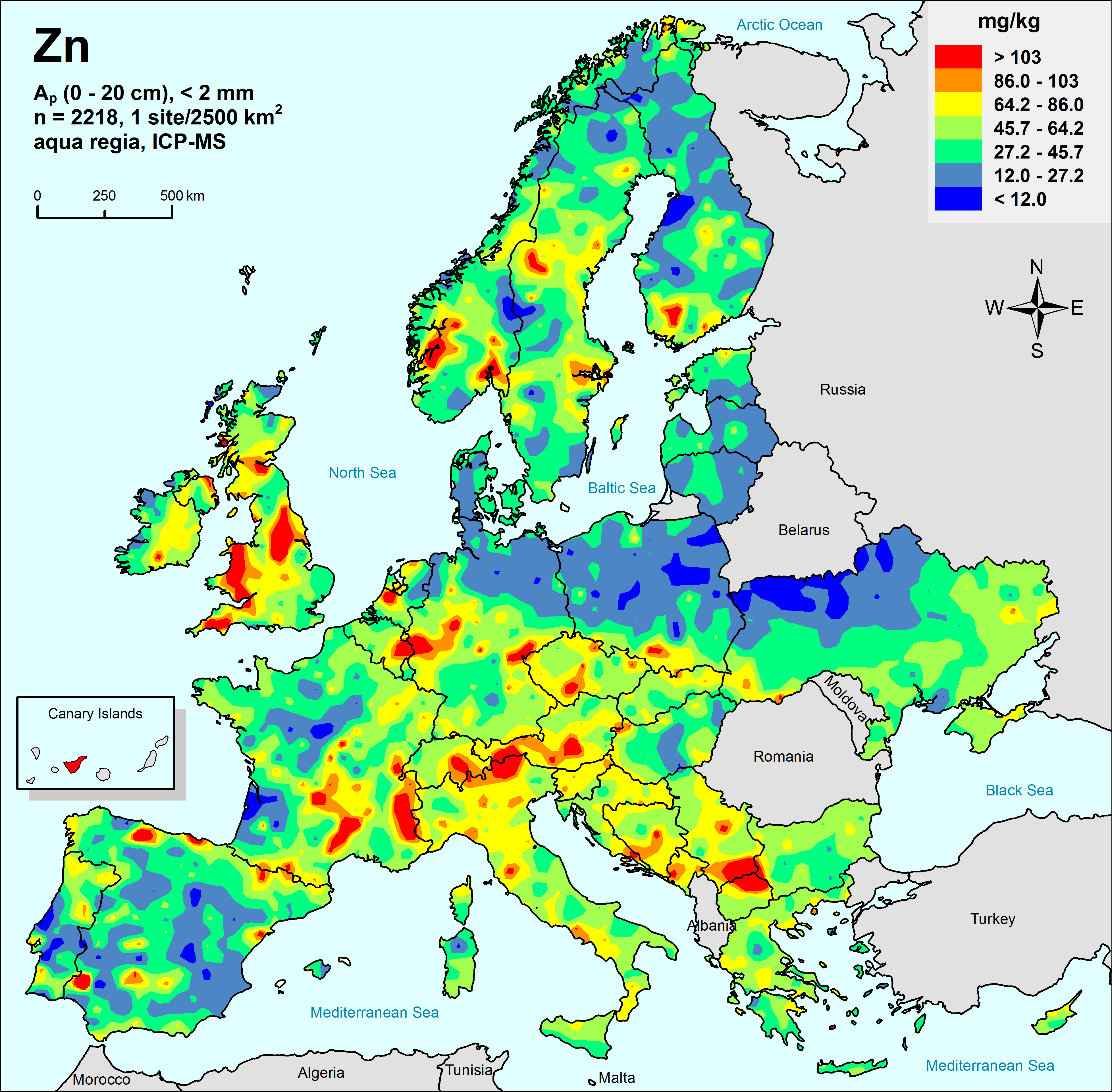
Figure 10: Geochemical maps showing the distribution of (a) copper (Cu) and (b) zinc (Zn) in agricultural soil samples. From Reimann et al., 2014c, Figs. 11.23.5, p.237 & 11.63.5, p.467, respectively.
Forensic applications
The GEMAS data sets deliver valuable information for forensic sciences and intelligence. Multi-element data sets, including some isotope systems, can be used to trace the origin of food or even human bodies (Morgan & Bull, 2006; Pye, 2007; Hoogewerff et al., 2019; Caritat et al., 2021). It is, thus, not surprising that forensic units of, for example, Scotland Yard and the Royal Canadian Mounted Police have expressed interest in the GEMAS data sets.
Discussion and conclusions
To make the GEMAS project possible 65 organisations – from almost all of the Geological Surveys of Europe, other State and contract research organisations, universities to industry – have cooperated to produce fully harmonised, strictly quality controlled and freely available data sets at the scale of a continent. For the first time, the GEMAS project provides fully harmonised data for chemical element concentrations and soil properties known to influence their bioavailability and toxicity in agricultural and grazing land soils, the productive soils of Europe. Society has, therefore, a valuable reference data set, a 2008 timeline, to monitor future changes in its agricultural and grazing land soils, caused by both human or natural causes, and a set of reference soil samples for future research. Such an archive is invaluable for land use planning, industrial development, environmental protection, risk assessment, forensic science, agriculture and food tracing. In the case of a major disaster, natural or human-induced, the European authorities have a reference data and a sample set to assess the impact of such an event. Furthermore, a better awareness of element deficiency levels can lead to an increase in productivity and animal health.
To validate the veracity of the GEMAS data sets, results have been compared with residual and alluvial soil samples collected by another pan-European project, carried out by the Geochemistry Expert Group of EuroGeoSurveys, the FOREGS Geochemical Atlas of Europe (Salminen et al., 2005; De Vos, Tarvainen et al., 2006), which displays similar geochemical patterns. Moreover, the European Commission’s Joint Research Centre confirmed that high variation in Hg concentrations across Europe can be mostly explained by soil organic carbon content, vegetation, soil parent material and other natural soil-related processes rather than large scale diffuse pollution. Based on the results of the LUCAS project soil samples (0-20 cm), it was found that some mining activities and coal combustion sites have a regionally important role in the Hg distribution (Ballabio et al., 2021).
The patterns displayed on the geochemical maps discussed in this study are mainly related to the soil parent materials, with distinct differences observed between the lithology of northern and southern Europe. The concentration break for most elements coincides with the southern limit of the last glaciation, i.e., lower element values to its north and elevated values to its south. Of course, for some elements (e.g., Se) their spatial distribution depends on other factors, such as proximity to the sea and soil organic matter.
The recent FAO and UNEP report about the “Status of soil pollution in Europe” (FAO and UNEP, 2021) refers to a European Environmental Agency report (EEA, 2019) and states that “agriculture significantly contributes to diffuse soil and water pollution in Europe” (Eugenio and Ronzan, 2021, Chapter 8), which according to the citation has been taken from a European Environmental Agency report (EEA, 2019). Two metals are given as examples: Cd from mineral fertilisers and Cu from fungicides. This short statement does not consider the results of the GEMAS, FOREGS and LUCAS projects that show the importance of understanding geology, soil parent material and other soil properties, as well as the analytical method applied while assessing soil contamination at the European scale. Anomalies of Cu in vineyards and Cd in heavily fertilised areas of Europe are actually visible on the maps of the GEMAS project but certainly not at the continental scale; at best they are limited to the regional and rather the local scale.
As diffuse contamination is a much discussed topic, it is worth quoting Fabian et al. (2017), who make the following introductory statements:
“On the basis of experience from the local scale, for example from the proximity of a metal smelter, it is widely assumed that contamination always results in unusually high concentrations of the emitted element in soil, and monitoring activities are focusing on extreme values. However, dependent on signal intensity local contamination becomes indistinguishable from the natural background variation at a characteristic distance from the source, usually measured in metres to some kilometres, and in extreme cases 100−200 km. It is therefore a major challenge to identify and quantify diffuse contamination in soil as distinguished from local or regional contamination, because it cannot be clearly separated from a large natural background variation” (p. 6719).
In their conclusion, Fabian et al. (2017) state that “diffuse soil contamination at the continental-scale remains invisible in continental scale geochemical maps because the natural variation is still considerably larger and dominates spatial patterns of high concentrations. This solves the puzzle that in spite of substantial anthropogenic emissions, geochemical maps of Pb at the continental scale consistently reflect natural conditions, usually both geology and climate. Pb contamination therefore is rarely marked by high total Pb concentration, but rather by overabundant lower and medium concentrations of Pb” (p. 6725).
Hence, international organisations such as EEA, FAO and UNEP should be extra careful about reporting ‘global pollution analyses’ in their reports. The scale of anthropogenic induced contamination can be either overlooked or overestimated if the natural geochemical background is not taken into account.
As concluding remarks, the GEMAS project, has produced data sets with well comparable results for two soil types, agricultural (0-20 cm) and grazing land (0-10 cm) sampled at the European scale, leading to several major findings.
- A major difference in soil chemical composition is observed between the young northern and older southern European soil;
- On average there is a sixfold difference in the median concentration of elements among the 33 participating countries (up to a factor of more than 100-fold);
- Spatial element distributions depend mainly on geology and climate;
- High trace element concentrations in soil are most often related to mineral deposits and metallogenic provinces;
- The anthropogenic impact is hardly detectable at the European scale;
- Some cities (e.g., London, Paris) cause anthropogenic trace element anomalies (e.g., Au, Pb, Hg) in their near surroundings and element concentrations decrease rapidly with distance from the source;
- Risk assessment for metals like Cu shows that few soil samples have such high concentrations that they pose a potential toxic risk for soil organisms; most of these samples were taken in vineyards;
- Several important trace elements (minor nutrients, e.g., Cu, Zn) show such low levels over sizeable tracts of land in Europe that trace element deficiency is clearly an issue of concern.
Acknowledgements
The GEMAS project is a cooperative project of the EuroGeoSurveys Geochemistry Expert Group with a number of outside organisations (e.g., Alterra, The Netherlands; Norwegian Forest and Landscape Institute; Research Group Swiss Soil Monitoring Network, Swiss Research Station Agroscope Reckenholz-Tänikon, several Ministries of the Environment and University Departments of Geosciences, Chemistry and Mathematics in a number of European countries and New Zealand; ARCHE Consulting in Belgium; CSIRO Land and Water in Adelaide, Australia). The analytical work was co-financed by the following industry organisations: Eurometaux, European Borates Association, European Copper Institute, European Precious Metals Federation, International Antimony Association, International Lead Association-Europe, International Manganese Institute, International Molybdenum Association, International Tin Research Institute, International Zinc Association, The Cobalt Development Institute, The Nickel Institute, The (REACH) Selenium and Tellurium Consortium and The (REACH) Vanadium Consortium. The Directors of the European Geological Surveys and the additional participating organisations are thanked for making sampling of almost all of Europe in a tight time schedule possible. The Federal Institute for Geosciences and Natural Resourced (BGR), the Geological Survey of Norway and SGS (Canada) are thanked for special analytical input to the project. Review and editing comments by Magnus Johansson and Robin Nagano have improved the manuscript.
References
Albanese, S., Sadeghi, S., Lima, A., Cicchella, D., Dinelli, E., Valera, P., Falconi, M., Demetriades, A., De Vivo, B. & The GEMAS Project Team. 2015. GEMAS: Chromium, Ni, Co and Cu in agricultural and grazing land soil of Europe. Journal of Geochemical Exploration, 154. 81−93, http://doi.org/10.1016/j.gexplo.2015.01.004
Alloway, B.J. (Ed.). 2013. Heavy Metals in Soils: Trace Metals and Metalloids in Soils and their Bioavailability. Dordrecht: Springer.
Antoine, P., Catt, J.A., Lautridou, J-P. & Sommé, J. 2003. The loess and coversands of northern France and southern England. Journal of Quaternary Science, 18(3-4). 309−318, https://doi.org/10.1002/jqs.750
Ballabio, C., Jiskra, M., Osterwalder, S., Borrelli, P., Montanarella, L. & Panagos, P. 2021. A spatial assessment of mercury content in the European Union topsoil. Science of The Total Environment, 769, 144755. 13 pp. https://doi.org/10.1016/j.scitotenv.2020.144755
Baritz, R., Ernstsen, V. & Zirlewagen, D. 2014. Carbon Concentrations in European Agricultural and Grazing Land Soil. In: Reimann et al. (2014b), pp. 117−129.
Bertran, P., Allenet, G., Gé, T., Naughton, F., Poirier, P. & Sanchez Goñi, M.F. 2009. Coversand and Pleistocene palaeosols in the Landes region, southwestern France. Journal of Quaternary Science, 24(3). 259−269. https://doi.org/10.1002/jqs.1220
Birke, M., Reimann, C., Rauch, U., De Vivo, B., Halamić, J., Klos, V., Gosar, M. & Ladenberger, A. 2014a. Distribution of Cadmium in European Agricultural and Grazing Land Soil. In: Reimann et al (2014b), pp. 89−115.
Birke, M., Reimann, C. & Karl Fabian, K. 2014b. Analytical Methods Used in the GEMAS Project. In: Reimann et al. (2014a), pp. 41−46.
Birke, M., Rauch, U. & Reimann. C., 2014c. Supporting Information for Interpretation of Geochemical Maps. In: Reimann et al. (2014a), pp. 93−102.
Birke, M., Reimann, R., Oorts, K., Rauch, U., Demetriades, A., Dinelli, E., Ladenberger, A., Halamić, J. Gosar, M., Jähne-Klingberg, F. & The GEMAS Project Team. 2016. Use of GEMAS data for risk assessment of cadmium in European agricultural and grazing land soil under the REACH Regulation. Applied Geochemistry, 74. 109−121. http://dx.doi.org/10.1016/j.apgeochem.2016.08.014
Birke, M., Reimann, C., Rauch, U., Ladenberger, A., Demetriades, A., Jähne-Klingberg, F., Oorts, K., Gosar, M., Dinelli, E., Halamic, J. & The GEMAS Project Team 2017. GEMAS: Cadmium distribution and its sources in agricultural and grazing land soil of Europe – original data versus clr-transformed data. Journal of Geochemical Exploration, 173(1). 13−30. http://dx.doi.org/10.1016/j.gexplo.2016.11.007
Broman, E., Wallin, K., Stéen, M. & Cederlund, G. 2002. A wasting syndrome in Swedish moose (Alces alces): background and current hypotheses. Ambio, 31(5), 409−416, https://doi.org/10.1579/0044-7447-31.5.409
Caritat, P. de, Woods, B., Simpson, T., Nichols, C., Hoogenboom, L., Ilheo, A., Aberle, M.G. & Hoogewerff, J. 2021. Forensic soil provenancing in urban /suburban setting: A sequential multivariate approach. Journal of Forensic Science, 00:1-18, https://doi.org/10.1111/1556-4029.14727
Cicchella, D., Albanese, S., Birke, M., De Vivo, B., De Vos, W., Dinelli, E., Lima, A., O’Connor, P.J., Salpeteur, I. & Tarvainen, T. 2014. Natural Radioactive Elements U, Th and K in European Agricultural and Grazing Land Soil. In: Reimann et al. (2014b), 145−159.
De Vos, W., Tarvainen, T., Salminen, R., Reeder, S., De Vivo, B., Demetriades, A., Pirc, S., Batista, M.J., Marsina, K., Ottesen, R.T., O’Connor, P.J., Bidovec, M., Lima, A., Siewers, U., Smith, B., Taylor, H., Shaw, R., Salpeteur, I., Gregorauskiene, V., Halamic, J., Slaninka, I., Lax, K., Gravesen, P., Birke, M., Breward, N., Ander, E.L., Jordan, G., Duris, M., Klein, P., Locutura, J., Bel-lan, A., Pasieczna, A., Lis, J., Mazreku, A., Gilucis, A., Heitzmann, P., Klaver, G. & Petersell, V. 2006. Geochemical Atlas of Europe. Part 2 – Interpretation of Geochemical Maps, Additional Tables, Figures, Maps, and Related Publications. Geological Survey of Finland, Espoo. http://weppi.gtk.fi/publ/foregsatlas/
2002. Communication from the Commission to the Council, the European Parliament, the Economic and Social Committee and the Committee of the Regions Towards a Thematic Strategy for Soil Protection. Commission of the European Communities COM(2002) 179 final, 35 p. https://eur-lex.europa.eu/LexUriServ/LexUriServ.do?uri=COM:2002:0179:FIN:EN:PDF
2006. Regulation (EC) No 1907/2006 of the European Parliament and of the Council of 18 December 2006 concerning the Registration, Evaluation, Authorisation and Restriction of Chemicals (REACH), establishing a European Chemicals Agency, amending Directive 1999/45/EC and repealing Council Regulation (EEC) No 793/93 and Commission Regulation (EC) No 1488/94 as well as Council Directive 76/769/EEC and Commission Directives 91/155/EEC, 93/67/EEC, 93/105/EC and 2000/21/EC. Official Journal of the European Union, Luxembourg, L396. http://eur-lex.europa.eu/eli/reg/2006/1907/oj
EEA. 2019. The European environment – State and outlook 2020: knowledge for transition to a sustainable Europe. European Environmental Agency. Publications Office of the European Union, Luxembourg. http://doi.org/10.2800/96749
EGS-GWG. 2008. EuroGeoSurveys geochemical mapping of agricultural and grazing land in Europe (GEMAS) – Field manual. EuroGeoSurveys Geochemistry Working Group. Geological Survey of Norway, Trondheim, NGU report 2008.038, 46 p. http://www.ngu.no/upload/Publikasjoner/Rapporter/2008/2008_038.pdf
Eugenio, N.R. & Ronzan, M. 2021. Status of Soil Pollution in Europe. In: FAO and UNEP, Global Assessment of Soil Pollution: Report. Food and Agriculture Organization of the United Nations and United Nations Environment Program, Rome. http://www.fao.org/3/cb4894en/online/src/html/chapter-08-2.html
Fabian, C., Reimann, C., Fabian, K., Birke, M., Baritz, R., Haslinger, E. & The GEMAS Project Team. 2014. GEMAS: Spatial distribution of the pH of European agricultural and grazing land soil. Applied Geochemistry, 48. 207−216. https://doi.org/10.1016/j.apgeochem.2014.07.017
Fabian, K., Reimann, C., Caritat, P. de. 2017. Quantifying diffuse contamination: Method and application to Pb in soil. Environmental Science & Technology, 51(12). 6719−6726. https://doi.org/10.1021/acs.est.7b00741
FAO, 2019. The Future of Food Safety: There is no food security without food safety. Food and Agriculture Organization of the United Nations, CA4289EN/1/04.19. http://www.fao.org/3/ca4289en/CA4289EN.pdf
FAO & UNEP. 2021. Global Assessment of Soil Pollution: Report. Food and Agriculture Organization of the United Nations and United Nations Environment Program, Rome., https://doi.org/10.4060/cb4894en
Haase, D., Fink, J., Haase, G., Ruske, R., Pecsi, M., Richter, H., Altermann, M. & Jaeger, K.-D. 2007. Loess in Europe – its spatial distribution based on a European Loess Map, scale 1:2,500,00. Quaternary Science Reviews, 26(9-10). 1301−1312. https://doi.org/10.1016/j.quascirev.2007.02.003
Hoogewerff, J.A., Reimann, C., Ueckermann, H., Frei, R., Frei, K.M., van Aswegen, Th., Stirling, C., Reid, M., Clayton, A., Ladenberger, A. & The GEMAS Project Team. 2019. Bioavailable 87Sr/86Sr in European soils: A baseline for provenancing studies. Science of The Total Environment, 672. 1033−1044. https://doi.org/10.1016/j.scitotenv.2019.03.387
Jordan, G., Petrik, A., De Vivo, B., Albanese, S., Demetriades, A., Sadeghi, M. & The GEMAS Project Team. 2018. GEMAS: Spatial analysis of the Ni distribution on a continental-scale using digital image processing techniques on European agricultural soil data. Journal of Geochemical Exploration, 186. 143−157. https://doi.org/10.1016/j.gexplo.2017.11.011
Kabata-Pendias, A. & Mukherjee, A.B. 2007. Trace Elements from Soil to Human. Springer Verlag: Berlin, Heidelberg.
Kasse, C. 1997. Cold-climate aeolian sand-sheet formation in north-western Europe (c.14-12.4 ka): a response to permafrost degradation and increased aridity. Permafrost and Periglacial Processes, 8(3). 295−311. https://doi.org/10.1002/(SICI)1099-1530(199709)8:3<295::AID-PPP256>3.0.CO;2-0
Ladenberger, A., Demetriades, A., Birke, B., Reimann, C., Sadeghi, M., Andersson, M., Jonsson, E., Uhlbäck, J. & The GEMAS Project Team. 2015. GEMAS: Indium in agricultural soils of Europe – Its source and geochemical distribution pattern. Journal of Geochemical Exploration, 154. 61−80. https://doi.org/10.1016/j.gexplo.2014.11.020
Mackovych, D. & Lucivjansky, P. 2014. Preparation of GEMAS Project Samples and Standards. In: Reimann et al. (2014a), pp. 37−40.
Mann, A., Reimann, C., Caritat, P. de, Turner, N., Birke, M. & The GEMAS Project Team. 2015. Mobile Metal Ion® analysis of European agricultural soils: bioavailability, weathering, geogenic patterns and anthropogenic anomalies. Geochemistry: Exploration, Environment, Analysis, 15. 99-112. http://dx.doi.org/10.1144/geochem2014-279
Matschullat, J., Reimann, C., Birke, M., Santos Carvalho, D. dos & The GEMAS Project Team. 2018. GEMAS: CNS concentrations and C/N ratios in European agricultural soil. Science of the Total Environment, 627. 975−984. https://doi.org/10.1016/j.scitotenv.2018.01.214
Morgan, R.M & Bull, P.A. 2005. Data interpretation in forensic and soil geochemistry. Environmental Forensics, 7(4). 325−334. https://doi.org/10.1080/15275920600996248
Négrel, P., Ladenberger, A., Reimann, C., Birke, M., Sadeghi, M. & The GEMAS Project Team. 2016. GEMAS: Source, distribution patterns and geochemical behaviour of Ge in agricultural and grazing land soils at European continental scale. Applied Geochemistry, 72. 113−124. http://dx.doi.org/10.1016/j.apgeochem.2016.07.004
Négrel, P., De Vivo, B., Reimann, C., Ladenberger, A., Cicchella, D., Albanese, S., Birke, M., De Vos, W., Dinelli, E., Lima, A., O’Connor, P.J., Salpeteur, I., Tarvainen, T. & The GEMAS Project Team. 2018a. U-Th signatures of agricultural soil at the European continental scale (GEMAS): Distribution, weathering patterns and processes controlling their concentrations. Science of The Total Environment, 622-623. 1277−1293, https://doi.org/10.1016/j.scitotenv.2017.12.005
Négrel, P., Ladenberger, A., Reimann, C., Birke, M., Sadeghi, M., The GEMAS Project Team. 2018b. Distribution of Rb, Ga and Cs in agricultural land soils at European continental scale (GEMAS): Implications for weathering conditions and provenance. Chemical Geology, 479. 188−203. https://doi.org/10.1016/j.chemgeo.2018.01.009
Négrel, P., Ladenberger, A., Reimann, C., Birke, M., Demetriades, A., Sadeghi, M., The GEMAS Project Team. 2019. GEMAS: Geochemical background and mineral potential of emerging tech-critical elements in Europe revealed from low-sampling density geochemical mapping. Applied Geochemistry, Article 104425. 20 pp. https://doi.org/10.1016/j.apgeochem.2019.104425
Négrel, P., Ladenberger, A., Reimann, C., Birke, M., Demetriades, A., Sadeghi, M. & The GEMAS Project Team. 2021. GEMAS: Geochemical distribution of Mg in agricultural soil of Europe. Journal of Geochemical Exploration 221, 106706. 15 p. https://doi.org/10.1016/j.gexplo.2020.106706.
Oorts, K. & Schoeters, I. 2014. Use of Monitoring Data for Risk Assessment of Metals in Soil under the European REACH Regulation. In: Reimann et al. (2014b), pp. 189−202.
Oorts, K., Smolders, E., McGrath, S.P., Gestel, C.A.M. van, McLaughlin, M.J. & Carey, S. 2016. Derivation of ecological standards for risk assessment of molybdate in soil. Environmental Chemistry, 13(1). 168−180. http://dx.doi.org/10.1071/EN15086.
Ottesen, R.T., Birke, M., Finne, T.E., Gosar, M., Locutura, J., Reimann, C., Tarvainen, T. & The GEMAS Project Team. 2013. Mercury in European agricultural and grazing land soils. Applied Geochemistry, 33. 1–12. https://doi.org/10.1016/j.apgeochem.2012.12.013
Poňavič, M. & Scheib, A. 2014. Distribution of Selenium in European Agricultural and Grazing Land Soil. In: Reimann et al. (2014b), pp. 131−144.
Pye, K. 2007. Geological and Soil Evidence – Forensic Applications. Boca Raton: CRC Press Boca Raton. https://doi.org/10.1201/9781420004755
Reimann, C. 2014. Sample Material, Site Selection and Sampling. In: Reimann et al. (2014a), pp. 31−36.
Reimann, C. & Fabian, K. 2021. Diffuse soil contamination by antimony. In: F. Montserrat (Ed.), Antimony. Berlin, Boston: De Gruyter. 129−146. https://doi.org/10.1515/9783110668711-006
Reimann, C., Demetriades, A., Eggen, O.A., Filzmoser, P. & The EuroGeoSurveys Geochemistry Expert Group. 2009. The EuroGeoSurveys geochemical mapping of agricultural and grazing land soils project (GEMAS) – Evaluation of quality control results of aqua regia extraction analysis. Geological Survey of Norway, Trondheim, NGU report 2009.049. http://www.ngu.no/upload/Publikasjoner/Rapporter/2009/2009_049.pdf
Reimann, C., Demetriades, A., Eggen, O.A., Filzmoser, P. & the EuroGeoSurveys Geochemistry Expert Group. 2011. The EuroGeoSurveys GEochemical Mapping of Agricultural and grazing land Soils project (GEMAS) – Evaluation of quality control results of total C and S, total organic carbon (TOC), cation exchange capacity (CEC), XRF, pH, and particle size distribution (PSD) analysis. Geological Survey of Norway, Trondheim, NGU report 2011.043. http://www.ngu.no/upload/Publikasjoner/Rapporter/2011/2011_043.pdf
Reimann, C., Flem, B., Fabian, K., Birke, M., Ladenberger, A., Négrel, P., Demetriades, A., Hoogewerff, J., The GEMAS Project Team. 2012a. Lead and lead isotopes in agricultural soils of Europe – The continental perspective. Applied Geochemistry, 27. 532−542. https://doi.org/10.1016/j.apgeochem.2011.12.012
Reimann, C., Demetriades, A., Birke, M., Eggen, O. A., Filzmoser, P., Kriete, C. & EuroGeoSurveys Geochemistry Expert Group. 2012b. The EuroGeoSurveys Geochemical Mapping of Agricultural and grazing land Soils project (GEMAS) – Evaluation of quality control results of particle size estimation by MIR prediction, Pb-isotope and MMI® extraction analyses and results of the GEMAS ring test for the standards Ap and Gr. Geological Survey of Norway, Trondheim, NGU report 2012.051. http://www.ngu.no/upload/Publikasjoner/Rapporter/2012/2012_051.pdf
Reimann, C., Birke, M., Demetriades, A., Filzmoser, P. & O’Connor, P. (Eds.). 2014a. Chemistry of Europe’s Agricultural Soils – Part A: Methodology and Interpretation of the GEMAS Data Set. Geologisches Jahrbuch (Reihe B 102), Hannover: Schweizerbarth.
Reimann, C., Birke, M., Demetriades, A., Filzmoser, P. & O’Connor, P. (Eds.). 2014b. Chemistry of Europe’s Agricultural Soils – Part B: General Background Information and Further Analysis of the GEMAS Data Set. Geologisches Jahrbuch (Reihe B 103), Hannover: Schweizerbarth
Reimann, C., Demetriades, A., Birke, M., Filzmoser P., O’Connor, P., Halamić, J., Ladenberger, A. & The GEMAS Project Team. 2014c. Distribution of Elements/Parameters in Agricultural and Grazing Land Soil of Europe. In: Reimann et al. (2014a), pp. 103−474.
Reimann, C., Birke, M., Demetriades, A., Filzmoser, P. & O’Connor, P. (Editors), 2014d. Appendix A: Soil Guideline Values (SGVs) for Agricultural and Grazing Land Soil in Different European Countries. Appendix A In: Reimann et al. (2014b), pp. 299−305.
Sadeghi, M., Petrosino, P., Ladenberger , A., Albanese, S., Andersson, M., Morris, G., Annamaria Lima, A., De Vivo, B. & The GEMAS Project Team. 2013. Ce, La and Y concentrations in agricultural and grazing-land soils of Europe. Journal of Geochemical Exploration, 133. 202−213. https://doi.org/10.1016/j.gexplo.2012.12.007
Salminen, R., Batista, M.J., Bidovec, M., Demetriades, A., De Vivo, B., De Vos, W., Duris, M., Gilucis, A., Gregorauskiene, V., Halamic, J., Heitzmann, P., Lima, A., Jordan, G., Klaver, G., Klein, P., Lis, J., Locutura, J., Marsina, K., Mazreku, A., O’Connor, P.J., Olsson, S.Å., Ottesen, R.T., Petersell, V., Plant, J.A., Reeder, S., Salpeteur, I., Sandström, H., Siewers, U., Steenfelt, A. & Tarvainen, T.. 2005. FOREGS Geochemical Atlas of Europe, Part 1: Background Information, Methodology and Maps. Espoo: Geological Survey of Finland. http://weppi.gtk.fi/publ/foregsatlas/
Scheib, A. 2014. Distribution of Aeolian Deposits in Europe and Their Influence on Soil Geochemistry. 9 In: Reimann et al. (2014b), pp. 161−168.
Scheib, J., Flight, D.M.A, Birke, M., Tarvainen, T., Locutura, J. & The GEMAS Project Team. 2012. The geochemistry of niobium and its distribution and relative mobility in agricultural soils of Europe. Geochemistry: Exploration, Environment, Analysis, 12. 293−302. http://dx.doi.org/10.1144/geochem2011-096
Tarvainen, T., Albanese, S., Birke, M., Poňavič, M., Reimann, C., The GEMAS Project Team. 2013. Arsenic in agricultural and grazing land soils of Europe. Applied Geochemistry, 28. 2−10. https://doi.org/10.1016/j.apgeochem.2012.10.005
Tarvainen, T., Birke, M., Reimann, C., Poňavič, M. & Albanese, S., 2014. Arsenic Anomalies in European Agricultural and Grazing Land Soil. In: Reimann et al. (2014b), pp. 81-88.
Xu, H., Demetriades, A., Reimann, C., Jiménez, J.J., Filser, J., Zhang, C. & The GEMAS Project Team. 2019. Identification of the co-existence of low total organic carbon contents and low pH values in agricultural soil in north-central Europe using hot spot analysis based on GEMAS project data. Science of The Total Environment, 678., 94−104. https://doi.org/10.1016/j.scitotenv.2019.04.382
Zeeberg, J.J. 1998. The European sand belt in Eastern Europe – and comparison of Late Glacial dune orientation with GCM simulation results. Boreas, 27(2). 127−139. https://doi.org/10.1111/j.1502-3885.1998.tb00873.x
This article has been published in European Geologist Journal 52 – Soil – Our endangered food base
Read here the full issue:
